Keene Topo Map New Hampshire
To zoom in, hover over the map of Keene
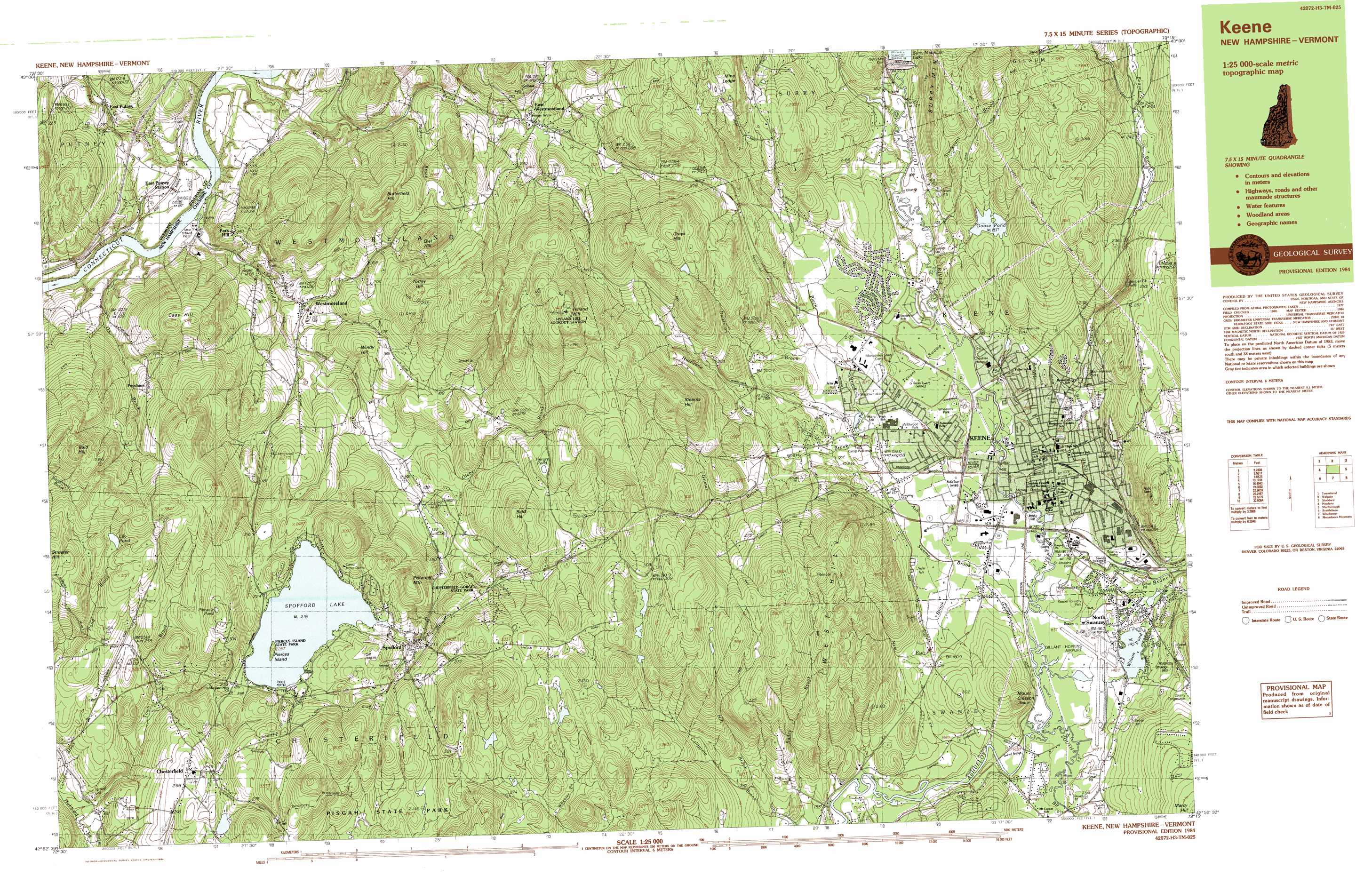
USGS Topo Quad 42072h3 - 1:25,000 scale
| Topo Map Name: | Keene |
| USGS Topo Quad ID: | 42072h3 |
| Print Size: | ca. 39" wide x 24" high |
| Southeast Coordinates: | 42.875° N latitude / 72.25° W longitude |
| Map Center Coordinates: | 42.9375° N latitude / 72.375° W longitude |
| U.S. State: | NH |
| Filename: | k42072h3.jpg |
| Download Map JPG Image: | Keene topo map 1:25,000 scale |
| Map Type: | Topographic |
| Topo Series: | 7.5´x15´ |
| Map Scale: | 1:25,000 |
| Source of Map Images: | United States Geological Survey (USGS) |
| Alternate Map Versions: |
Keene NH 1984, updated 1984 Download PDF Buy paper map Keene NH 1984, updated 1984 Download PDF Buy paper map |
1:24,000 Topo Quads surrounding Keene
Saxtons River |
Alstead |
Washington |
||
Westminster West |
Gilsum |
Stoddard |
||
Putney |
Keene |
Dublin |
||
Brattleboro |
West Swanzey |
Monadnock Mountain |
||
Bernardston |
Mount Grace |
Winchendon |
> Back to 42072e1 at 1:100,000 scale
> Back to 42072a1 at 1:250,000 scale
> Back to U.S. Topo Maps home
Keene topo map: Gazetteer
Keene: Airports
Dillant-Hopkins Airport elevation 143m 469′Keene: Areas
Surry Mountain Flood Control Area elevation 156m 511′Keene: Benches
Mine Ledge elevation 386m 1266′Keene: Bridges
East Putney Brook Stone Arch Bridge elevation 120m 393′Sawyers Crossing Bridge elevation 143m 469′
Keene: Dams
Ashuelot River Dam elevation 142m 465′Goose Pond Dam elevation 193m 633′
Lower Wilson Pond Dam elevation 146m 479′
Robinhood Park Reservoir Dam elevation 177m 580′
Rodgers Pond Dam elevation 156m 511′
Spofford Lake Dam elevation 218m 715′
Surry Mountain Dam elevation 151m 495′
Surry Mountain Dam elevation 169m 554′
Upper Wilson Pond Dam elevation 150m 492′
Keene: Falls
Beaver Brook Falls elevation 222m 728′Keene: Forests
Beech Hill State Forest elevation 278m 912′Keene: Islands
Pierces Island elevation 224m 734′Keene: Lakes
Harvey Pond elevation 256m 839′Lily Pond elevation 292m 958′
Pinnacle Pond elevation 340m 1115′
Wilson Pond elevation 154m 505′
Wilson Pond elevation 145m 475′
Keene: Parks
Alumni Field elevation 154m 505′Ashuelot River Park elevation 147m 482′
Ashuelot River Park elevation 147m 482′
Beech Hill Preserve elevation 312m 1023′
Central Square elevation 148m 485′
Chesterfield Gorge State Park elevation 217m 711′
Childrens Wood elevation 198m 649′
Drummer Hill Preserve elevation 229m 751′
Ells-Harrison Park elevation 153m 501′
Fuller Park elevation 154m 505′
Hickey-Desilets Park elevation 144m 472′
Horatio Colony Trust elevation 338m 1108′
Joyce Athletic Field elevation 144m 472′
Keene City Park elevation 173m 567′
Keene Forestry Park elevation 150m 492′
Keene State College Soccer Field elevation 144m 472′
Ladies Park elevation 152m 498′
Park Hill Common elevation 150m 492′
Pierces Island State Park elevation 224m 734′
Robin Hood Forest elevation 225m 738′
Shadow Lake Park elevation 209m 685′
The Dinsmoor Woods elevation 158m 518′
Keene: Populated Places
Camp Notre Dame elevation 233m 764′Chesterfield elevation 260m 853′
East Putney elevation 115m 377′
East Westmoreland elevation 182m 597′
Gilboa elevation 205m 672′
Harper Acres elevation 145m 475′
Hillside Acres Mobile Home Park elevation 150m 492′
Joslin elevation 156m 511′
Keene elevation 148m 485′
Longmeadow Subdivision elevation 168m 551′
Maple Acres elevation 160m 524′
North Swanzey elevation 151m 495′
Poocham elevation 206m 675′
Spofford elevation 210m 688′
Spragueville elevation 145m 475′
Swanzey Station elevation 144m 472′
Tanglewood Estates elevation 149m 488′
Westmoreland elevation 128m 419′
Keene: Reservoirs
Ashuelot River Reservoir elevation 142m 465′Goose Pond elevation 193m 633′
Robinhood Park Reservoir elevation 177m 580′
Rodgers Pond elevation 156m 511′
Shadow Lake elevation 156m 511′
Spofford Lake elevation 218m 715′
Surry Mountain Lake elevation 153m 501′
Upper Wilson Pond elevation 150m 492′
Wilson Pond elevation 146m 479′
Keene: Streams
Ash Swamp Brook elevation 142m 465′Beaver Brook elevation 138m 452′
Beaver Brook elevation 144m 472′
Black Brook elevation 150m 492′
Dickinson Brook elevation 156m 511′
East Putney Brook elevation 68m 223′
Glebe Brook elevation 121m 396′
Grimes Brook elevation 164m 538′
Hart Brook elevation 199m 652′
Hill Brook elevation 171m 561′
Hubbard Brook elevation 148m 485′
Hurricane Brook elevation 164m 538′
Mill Brook elevation 69m 226′
New Run Brook elevation 144m 472′
Ox Brook elevation 67m 219′
Partridge Brook elevation 68m 223′
South Branch Ashuelot River elevation 142m 465′
Sturtevant Brook elevation 147m 482′
The Branch elevation 143m 469′
Town Brook elevation 150m 492′
White Brook elevation 149m 488′
Keene: Summits
Bald Hill elevation 396m 1299′Bald Hill elevation 314m 1030′
Beech Hill elevation 314m 1030′
Butterfield Hill elevation 354m 1161′
Cass Hill elevation 310m 1017′
Grays Hill elevation 418m 1371′
Hyland Hill elevation 456m 1496′
Hyland Hill elevation 458m 1502′
Mount Cresson elevation 248m 813′
Owl Hill elevation 314m 1030′
Owls Hill elevation 312m 1023′
Park Hill elevation 150m 492′
Pistareen Mountain elevation 326m 1069′
Stearns Hill elevation 389m 1276′
Streeter Hill elevation 368m 1207′
Torrey Hill elevation 308m 1010′
West Hill elevation 407m 1335′
Windy Hill elevation 210m 688′
Keene: Swamps
Tenant Swamp elevation 148m 485′Keene digital topo map on disk
Buy this Keene topo map showing relief, roads, GPS coordinates and other geographical features, as a high-resolution digital map file on DVD:
New York, Vermont, Connecticut & Western Massachusetts
Buy digital topo maps: New York, Vermont, Connecticut & Western Massachusetts