Otis Topo Map Massachusetts
To zoom in, hover over the map of Otis
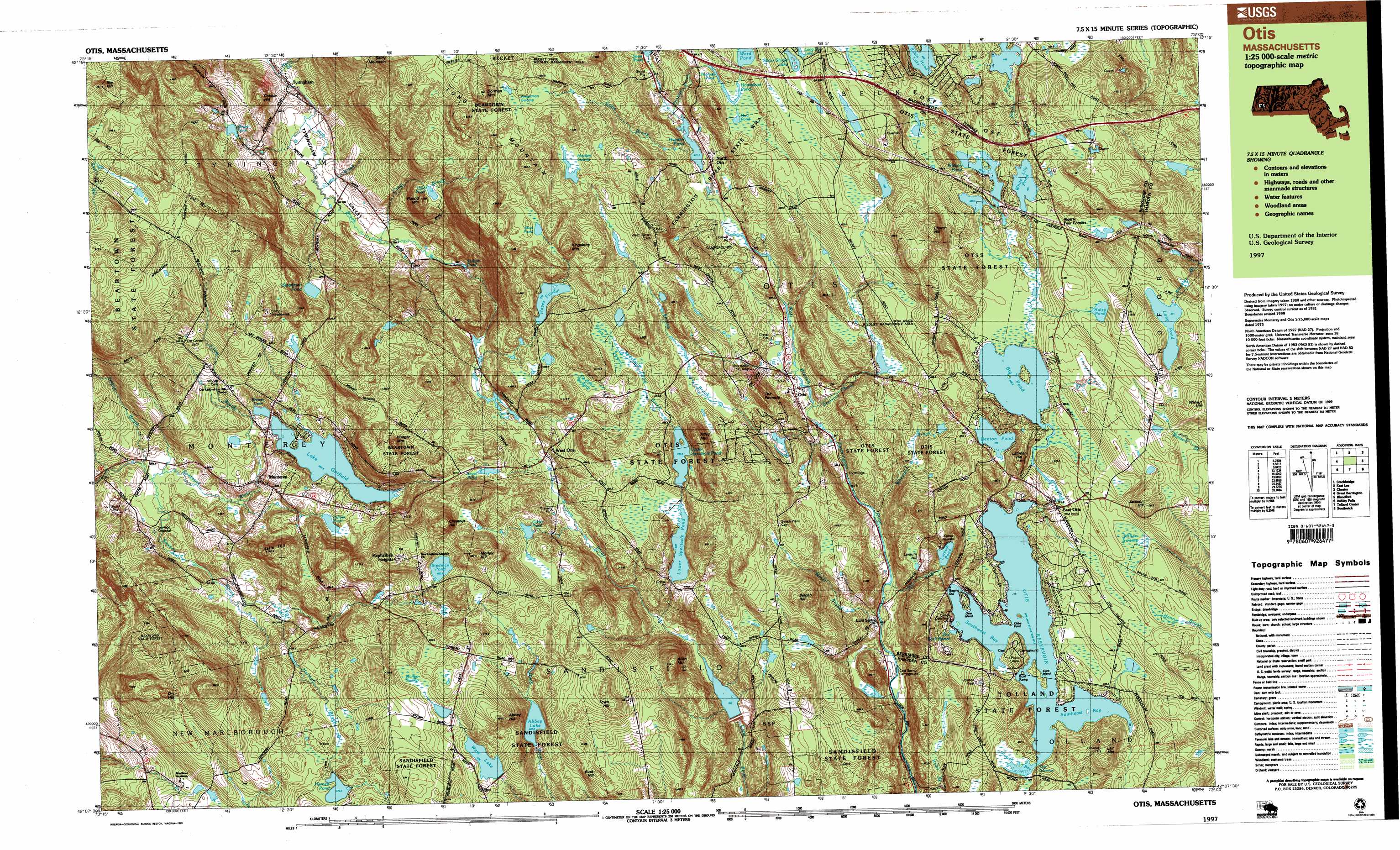
USGS Topo Quad 42073b1 - 1:25,000 scale
| Topo Map Name: | Otis |
| USGS Topo Quad ID: | 42073b1 |
| Print Size: | ca. 39" wide x 24" high |
| Southeast Coordinates: | 42.125° N latitude / 73° W longitude |
| Map Center Coordinates: | 42.1875° N latitude / 73.125° W longitude |
| U.S. State: | MA |
| Filename: | k42073b1.jpg |
| Download Map JPG Image: | Otis topo map 1:25,000 scale |
| Map Type: | Topographic |
| Topo Series: | 7.5´x15´ |
| Map Scale: | 1:25,000 |
| Source of Map Images: | United States Geological Survey (USGS) |
| Alternate Map Versions: |
Otis MA 1987, updated 1988 Download PDF Buy paper map Otis MA 1997, updated 1999 Download PDF Buy paper map |
1:24,000 Topo Quads surrounding Otis
Pittsfield West |
Peru |
Goshen |
||
Stockbridge |
Becket |
Westhampton |
||
Great Barrington |
Otis |
Woronoco |
||
Ashley Falls |
Tolland Center |
Southwick |
||
South Canaan |
Norfolk |
Winsted |
New Hartford |
Tariffville |
> Back to 42073a1 at 1:100,000 scale
> Back to 42072a1 at 1:250,000 scale
> Back to U.S. Topo Maps home
Otis topo map: Gazetteer
Otis: Bays
Dismal Bay elevation 431m 1414′Southeast Bay elevation 431m 1414′
Southwest Bay elevation 431m 1414′
The Pork Barrel elevation 433m 1420′
Otis: Capes
Kibbe Point elevation 432m 1417′Otis: Dams
Abbey Lake Dam elevation 448m 1469′Camp Sequena Dam elevation 368m 1207′
Clam Lake Dam elevation 362m 1187′
Gilder Pond Dam elevation 448m 1469′
Harnett Pond Dam elevation 471m 1545′
Hayden Pond Dam elevation 402m 1318′
Hayes Pond Dam elevation 479m 1571′
Indian Lake Dam elevation 449m 1473′
Lake Garfield Dam elevation 395m 1295′
Long Pond Dam elevation 471m 1545′
Lower Spectacle Pond Dam elevation 438m 1437′
Morley Swamp Dam elevation 500m 1640′
Otis Reservoir Dam elevation 432m 1417′
Royal Pond Dam elevation 443m 1453′
Shaker Pond Dam elevation 377m 1236′
Steadman Pond Dam elevation 401m 1315′
Stedman Pond Dam elevation 480m 1574′
Upper Spectacle Pond Dam elevation 438m 1437′
Watson Pond Dam elevation 458m 1502′
West Lake Dam elevation 479m 1571′
White Lily Pond Dam elevation 468m 1535′
Otis: Falls
Otis Falls elevation 404m 1325′Otis: Forests
Tolland State Forest elevation 444m 1456′Otis: Guts
The Narrows elevation 442m 1450′Otis: Islands
Clark Island elevation 431m 1414′Gate Island elevation 439m 1440′
Otis: Lakes
Benton Pond elevation 448m 1469′Big Pond elevation 448m 1469′
Curtin Pond elevation 410m 1345′
Horseshoe Pond elevation 469m 1538′
Larkum Pond elevation 391m 1282′
Mud Pond elevation 551m 1807′
Mud Pond elevation 446m 1463′
Mud Pond elevation 469m 1538′
Palmer Pond elevation 420m 1377′
Spectacle Ponds elevation 429m 1407′
Thomas Pond elevation 466m 1528′
Ward Pond elevation 472m 1548′
Otis: Populated Places
Algerie Four Corners elevation 471m 1545′Camp Jayson elevation 399m 1309′
Cold Spring elevation 353m 1158′
East Otis elevation 452m 1482′
Hephzibah Heights elevation 470m 1541′
Monterey elevation 388m 1272′
North Otis elevation 414m 1358′
Otis elevation 373m 1223′
Otis Wood Lanes elevation 423m 1387′
Tyringham elevation 275m 902′
West Otis elevation 430m 1410′
Otis: Post Offices
Monterey Post Office elevation 393m 1289′Otis: Ranges
Berkshire Hills elevation 473m 1551′Otis: Reservoirs
Abbey Lake elevation 448m 1469′Benton Brook Reservoir elevation 368m 1207′
Clam Lake Reservoir elevation 362m 1187′
Excalibur Lake elevation 464m 1522′
Gilder Pond elevation 449m 1473′
Hale Pond elevation 424m 1391′
Harnett Pond elevation 471m 1545′
Hayden Pond elevation 402m 1318′
Hayes Pond elevation 479m 1571′
Indian Lake Reservoir elevation 449m 1473′
Lake Garfield elevation 411m 1348′
Long Pond elevation 471m 1545′
Lower Spectacle Pond elevation 438m 1437′
Morley Swamp Reservoir elevation 500m 1640′
Otis Reservoir elevation 432m 1417′
Royal Pond elevation 448m 1469′
Shaker Pond elevation 377m 1236′
Silver Shield Lake elevation 499m 1637′
Sodem Pond elevation 301m 987′
Steadman Pond elevation 401m 1315′
Stedman Pond elevation 482m 1581′
Upper Spectacle Pond elevation 437m 1433′
Watson Pond elevation 458m 1502′
West Lake elevation 479m 1571′
White Lily Pond elevation 468m 1535′
Otis: Ridges
Otis Ridge elevation 497m 1630′Otis: Streams
Benton Brook elevation 365m 1197′Camp Brook elevation 284m 931′
Cone Brook elevation 402m 1318′
Crystal Brook elevation 327m 1072′
Dimmock Brook elevation 368m 1207′
Fall River elevation 354m 1161′
Harmon Brook elevation 374m 1227′
Loom Brook elevation 388m 1272′
Miner Brook elevation 443m 1453′
Rawson Brook elevation 352m 1154′
Spectacle Pond Brook elevation 366m 1200′
Swann Brook elevation 354m 1161′
Thomas Brook elevation 402m 1318′
Wheeler Brook elevation 357m 1171′
Otis: Summits
Abbey Hill elevation 544m 1784′Allen Mountain elevation 513m 1683′
Belden Hill elevation 497m 1630′
Buck Hill elevation 494m 1620′
Chestnut Hill elevation 561m 1840′
Church Hill elevation 565m 1853′
Cobble Hill elevation 414m 1358′
Dorman Mountain elevation 595m 1952′
Dry Hill elevation 531m 1742′
Filley Mountain elevation 522m 1712′
Halls Hill elevation 468m 1535′
Hunger Mountain elevation 539m 1768′
Jackson Hill elevation 520m 1706′
Kingsbury Mountain elevation 581m 1906′
Lair Mountain elevation 513m 1683′
Larkum Hill elevation 432m 1417′
Latimer Hill elevation 491m 1610′
Morley Hill elevation 561m 1840′
Round Mountain elevation 460m 1509′
Sky Hill elevation 585m 1919′
The Pinacle elevation 477m 1564′
Town Hill elevation 538m 1765′
Otis: Swamps
Abbey Swamp elevation 544m 1784′Angerman Swamp elevation 521m 1709′
Geisler Swamp elevation 458m 1502′
Hale Swamp elevation 424m 1391′
Hayden Swamp elevation 497m 1630′
Miller Swamp elevation 463m 1519′
Phelps Swamp elevation 467m 1532′
Otis: Valleys
Tyringham Valley elevation 284m 931′Otis digital topo map on disk
Buy this Otis topo map showing relief, roads, GPS coordinates and other geographical features, as a high-resolution digital map file on DVD:
New York, Vermont, Connecticut & Western Massachusetts
Buy digital topo maps: New York, Vermont, Connecticut & Western Massachusetts