Great Barrington Topo Map Massachusetts
To zoom in, hover over the map of Great Barrington
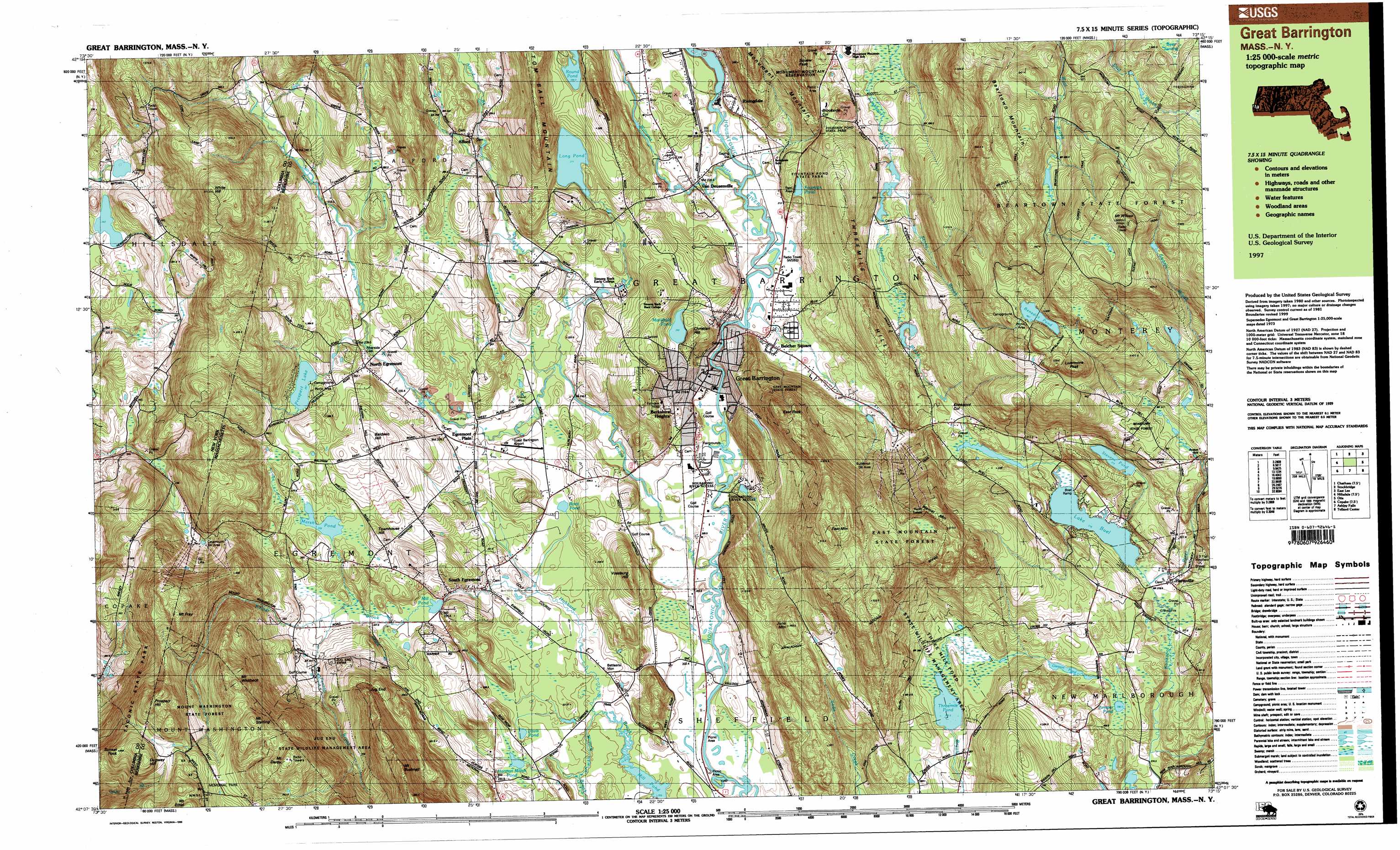
USGS Topo Quad 42073b3 - 1:25,000 scale
| Topo Map Name: | Great Barrington |
| USGS Topo Quad ID: | 42073b3 |
| Print Size: | ca. 39" wide x 24" high |
| Southeast Coordinates: | 42.125° N latitude / 73.25° W longitude |
| Map Center Coordinates: | 42.1875° N latitude / 73.375° W longitude |
| U.S. State: | MA |
| Filename: | k42073b3.jpg |
| Download Map JPG Image: | Great Barrington topo map 1:25,000 scale |
| Map Type: | Topographic |
| Topo Series: | 7.5´x15´ |
| Map Scale: | 1:25,000 |
| Source of Map Images: | United States Geological Survey (USGS) |
| Alternate Map Versions: |
Great Barrington MA 1987, updated 1988 Download PDF Buy paper map Great Barrington MA 1997, updated 1999 Download PDF Buy paper map |
1:24,000 Topo Quads surrounding Great Barrington
East Chatham |
Pittsfield West |
Peru |
||
Chatham |
Stockbridge |
Becket |
||
Hillsdale |
Great Barrington |
Otis |
||
Copake |
Ashley Falls |
Tolland Center |
||
Millerton |
Sharon |
South Canaan |
Norfolk |
Winsted |
> Back to 42073a1 at 1:100,000 scale
> Back to 42072a1 at 1:250,000 scale
> Back to U.S. Topo Maps home
Great Barrington topo map: Gazetteer
Great Barrington: Airports
Great Barrington Airport elevation 223m 731′Great Barrington: Basins
Butternut Basin elevation 477m 1564′Great Barrington: Cliffs
Jug End elevation 454m 1489′Great Barrington: Dams
Barbieri Dam elevation 269m 882′Benedict Pond Dam elevation 493m 1617′
Berle Dam elevation 262m 859′
Gleason Pond Dam elevation 292m 958′
Long Pond Dam elevation 283m 928′
Mill Pond Dam elevation 226m 741′
Prospect Lake Dam elevation 264m 866′
Rising Paper Company Dam elevation 337m 1105′
Stevens Pond Dam elevation 315m 1033′
Threemile Pond Dam elevation 276m 905′
Great Barrington: Forests
Beartown State Forest elevation 525m 1722′East Mountain State Forest elevation 477m 1564′
Mount Washington State Forest elevation 448m 1469′
Great Barrington: Gaps
Brookside Col elevation 283m 928′Konkapot Col elevation 294m 964′
Great Barrington: Lakes
Davis Pond elevation 214m 702′Fountain Pond elevation 243m 797′
Haley Pond elevation 536m 1758′
Harman Marsh Pond elevation 216m 708′
Juniper Pond elevation 296m 971′
Lake Buel elevation 277m 908′
Mansfield Pond elevation 259m 849′
Root Pond elevation 218m 715′
Threemile Pond elevation 274m 898′
Great Barrington: Parks
Battlesite Monument elevation 208m 682′Monument Mountain Reservation elevation 395m 1295′
Newsboy Statue elevation 214m 702′
North Egremont Historic District elevation 242m 793′
South Egremont Village Historic District elevation 214m 702′
Great Barrington: Populated Places
Alford elevation 264m 866′Belcher Square elevation 216m 708′
Berkshire Heights elevation 227m 744′
Brookside elevation 206m 675′
Egremont Plain elevation 228m 748′
Great Barrington elevation 215m 705′
Hartsville elevation 281m 921′
North Egremont elevation 243m 797′
Risingdale elevation 305m 1000′
South Egremont elevation 223m 731′
Van Deusenville elevation 219m 718′
Great Barrington: Post Offices
Great Barrington Post Office elevation 216m 708′South Egremont Post Office elevation 218m 715′
Great Barrington: Reservoirs
Barbieri Reservoir elevation 269m 882′Benedict Pond elevation 493m 1617′
Berkshire Heights Reservoir elevation 305m 1000′
Berle Pond elevation 262m 859′
Gleason Pond elevation 292m 958′
Housatonic River Reservoir elevation 337m 1105′
Long Pond elevation 271m 889′
Mill Pond elevation 230m 754′
Prospect Lake elevation 264m 866′
Stevens Pond elevation 319m 1046′
The Cove elevation 209m 685′
Threemile Pond elevation 276m 905′
Great Barrington: Springs
Soda Springs elevation 336m 1102′Great Barrington: Streams
Alford Brook elevation 250m 820′Fenton Brook elevation 231m 757′
Green River elevation 201m 659′
Green River elevation 201m 659′
Karner Brook elevation 223m 731′
Long Pond Brook elevation 220m 721′
Muddy Brook elevation 261m 856′
Seekonk Brook elevation 213m 698′
Stony Brook elevation 257m 843′
Willard Brook elevation 205m 672′
Williams River elevation 210m 688′
Great Barrington: Summits
Baldwin Hill elevation 304m 997′Christian Hill elevation 276m 905′
Dugway Hill elevation 565m 1853′
East Mountain elevation 542m 1778′
East Rock elevation 456m 1496′
June Mountain elevation 372m 1220′
Livermore Peak elevation 560m 1837′
Mount Bushnell elevation 555m 1820′
Mount Darby elevation 619m 2030′
Mount Fray elevation 580m 1902′
Mount Sterling elevation 467m 1532′
Mount Whitbeck elevation 560m 1837′
Mount Wilcox elevation 642m 2106′
Prospect Hill elevation 581m 1906′
Prospect Hill elevation 582m 1909′
Squaw Peak elevation 477m 1564′
Sunset Rock elevation 545m 1788′
Three Mile Hill elevation 309m 1013′
Townhouse Hill elevation 284m 931′
Vossburg Hill elevation 302m 990′
Warner Mountain elevation 529m 1735′
White Hill elevation 510m 1673′
Great Barrington: Swamps
Bear Swamp elevation 527m 1729′Marsh Pond elevation 261m 856′
Great Barrington: Trails
Wild Cat Trail elevation 548m 1797′Great Barrington: Valleys
Guilder Hollow elevation 312m 1023′Great Barrington digital topo map on disk
Buy this Great Barrington topo map showing relief, roads, GPS coordinates and other geographical features, as a high-resolution digital map file on DVD:
New York, Vermont, Connecticut & Western Massachusetts
Buy digital topo maps: New York, Vermont, Connecticut & Western Massachusetts