Claverack Topo Map New York
To zoom in, hover over the map of Claverack
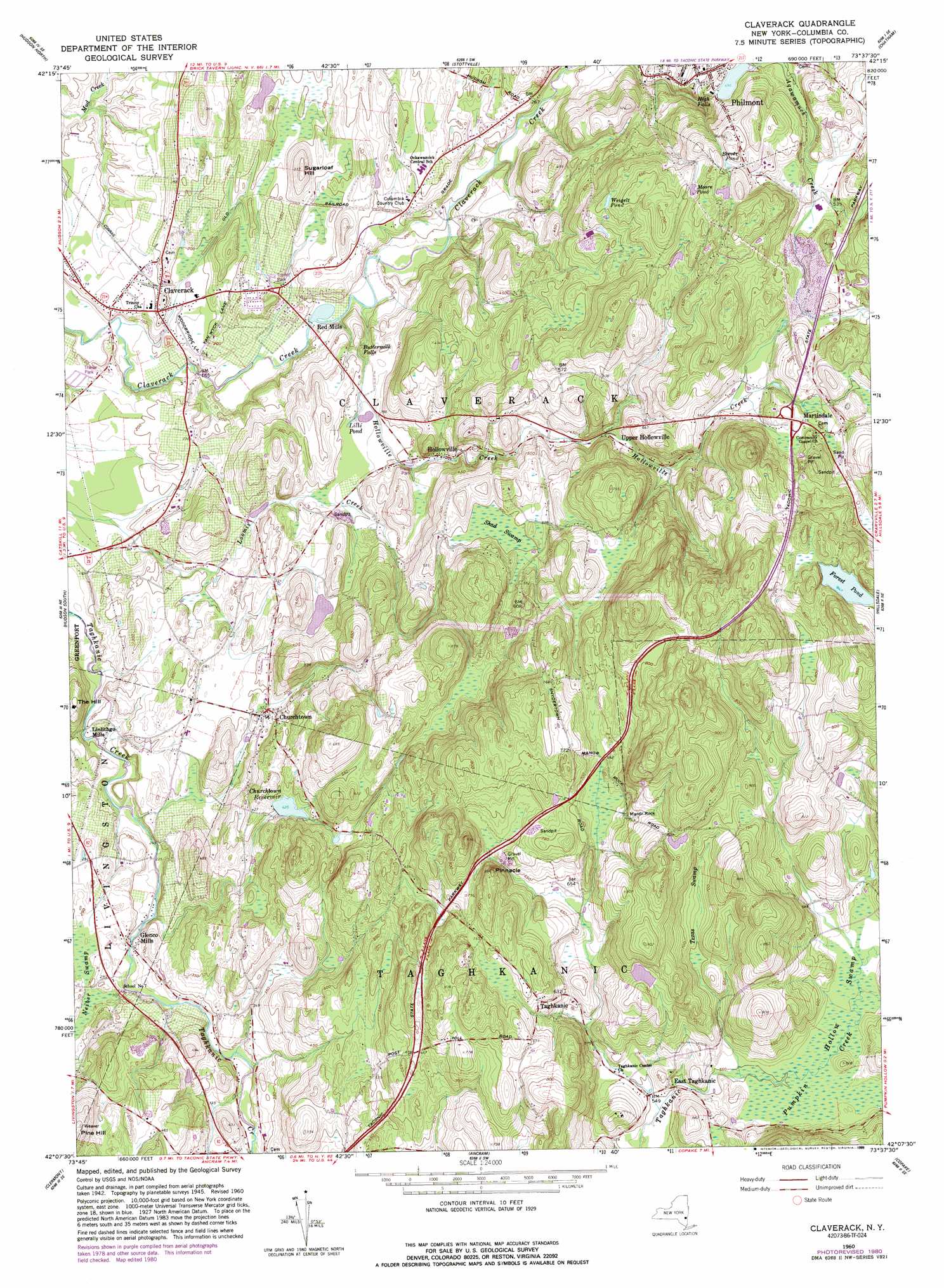
USGS Topo Quad 42073b6 - 1:24,000 scale
| Topo Map Name: | Claverack |
| USGS Topo Quad ID: | 42073b6 |
| Print Size: | ca. 21 1/4" wide x 27" high |
| Southeast Coordinates: | 42.125° N latitude / 73.625° W longitude |
| Map Center Coordinates: | 42.1875° N latitude / 73.6875° W longitude |
| U.S. State: | NY |
| Filename: | o42073b6.jpg |
| Download Map JPG Image: | Claverack topo map 1:24,000 scale |
| Map Type: | Topographic |
| Topo Series: | 7.5´ |
| Map Scale: | 1:24,000 |
| Source of Map Images: | United States Geological Survey (USGS) |
| Alternate Map Versions: |
Claverack NY 1947, updated 1980 Download PDF Buy paper map Claverack NY 1960, updated 1962 Download PDF Buy paper map Claverack NY 1960, updated 1970 Download PDF Buy paper map Claverack NY 1960, updated 1981 Download PDF Buy paper map Claverack NY 1960, updated 1989 Download PDF Buy paper map Claverack NY 2010 Download PDF Buy paper map Claverack NY 2013 Download PDF Buy paper map Claverack NY 2016 Download PDF Buy paper map |
1:24,000 Topo Quads surrounding Claverack
Alcove |
Ravena |
Kinderhook |
East Chatham |
|
Leeds |
Hudson North |
Stottville |
Chatham |
|
Cementon |
Hudson South |
Claverack |
Hillsdale |
|
Saugerties |
Clermont |
Ancram |
Copake |
|
Kingston East |
Rock City |
Pine Plains |
Millerton |
Sharon |
> Back to 42073a1 at 1:100,000 scale
> Back to 42072a1 at 1:250,000 scale
> Back to U.S. Topo Maps home
Claverack topo map: Gazetteer
Claverack: Falls
Buttermilk Falls elevation 80m 262′High Falls elevation 142m 465′
Claverack: Lakes
Forest Pond elevation 258m 846′Hess Pond elevation 100m 328′
Lilli Pond elevation 85m 278′
Moore Pond elevation 189m 620′
Stever Pond elevation 194m 636′
Weigelt Pond elevation 184m 603′
Claverack: Pillars
Manor Rock elevation 211m 692′Pinnacle elevation 265m 869′
Claverack: Populated Places
Churchtown elevation 99m 324′Claverack elevation 62m 203′
East Taghkanic elevation 171m 561′
Glenco Mills elevation 75m 246′
Hollowville elevation 99m 324′
Hollowville Trailer Park elevation 93m 305′
Jutkosky Court elevation 53m 173′
Linlithgo Mills elevation 61m 200′
Martindale elevation 186m 610′
Philmont elevation 124m 406′
Red Mills elevation 51m 167′
Taghkanic elevation 221m 725′
Upper Hollowville elevation 138m 452′
Claverack: Reservoirs
Churchtown Reservoir elevation 129m 423′Claverack: Streams
Hollowville Creek elevation 53m 173′Claverack: Summits
Pine Hill elevation 186m 610′Sugarloaf Hill elevation 114m 374′
The Hill elevation 107m 351′
Claverack: Swamps
Neiber Swamp elevation 84m 275′Pumpkin Hollow Swamp elevation 169m 554′
Shad Swamp elevation 151m 495′
Texas Swamp elevation 196m 643′
Claverack digital topo map on disk
Buy this Claverack topo map showing relief, roads, GPS coordinates and other geographical features, as a high-resolution digital map file on DVD:
New York, Vermont, Connecticut & Western Massachusetts
Buy digital topo maps: New York, Vermont, Connecticut & Western Massachusetts