Chatham Topo Map New York
To zoom in, hover over the map of Chatham
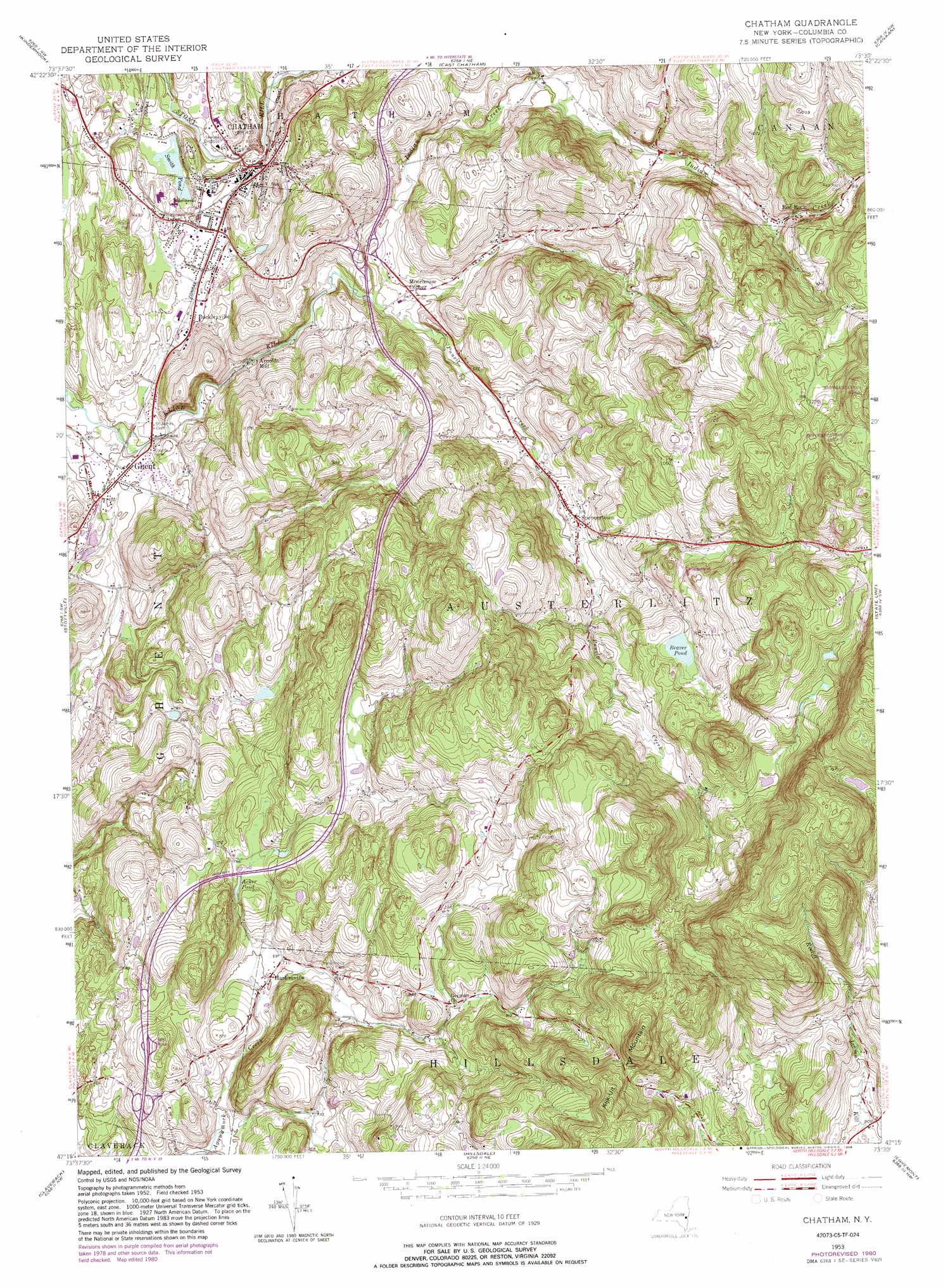
USGS Topo Quad 42073c5 - 1:24,000 scale
| Topo Map Name: | Chatham |
| USGS Topo Quad ID: | 42073c5 |
| Print Size: | ca. 21 1/4" wide x 27" high |
| Southeast Coordinates: | 42.25° N latitude / 73.5° W longitude |
| Map Center Coordinates: | 42.3125° N latitude / 73.5625° W longitude |
| U.S. State: | NY |
| Filename: | o42073c5.jpg |
| Download Map JPG Image: | Chatham topo map 1:24,000 scale |
| Map Type: | Topographic |
| Topo Series: | 7.5´ |
| Map Scale: | 1:24,000 |
| Source of Map Images: | United States Geological Survey (USGS) |
| Alternate Map Versions: |
Chatham NY 1953, updated 1955 Download PDF Buy paper map Chatham NY 1953, updated 1967 Download PDF Buy paper map Chatham NY 1953, updated 1977 Download PDF Buy paper map Chatham NY 1953, updated 1981 Download PDF Buy paper map Chatham NY 1953, updated 1988 Download PDF Buy paper map Chatham NY 2010 Download PDF Buy paper map Chatham NY 2013 Download PDF Buy paper map Chatham NY 2016 Download PDF Buy paper map |
1:24,000 Topo Quads surrounding Chatham
Delmar |
East Greenbush |
Nassau |
Hancock |
|
Ravena |
Kinderhook |
East Chatham |
Pittsfield West |
|
Hudson North |
Stottville |
Chatham |
Stockbridge |
|
Hudson South |
Claverack |
Hillsdale |
Great Barrington |
|
Clermont |
Ancram |
Copake |
Ashley Falls |
> Back to 42073a1 at 1:100,000 scale
> Back to 42072a1 at 1:250,000 scale
> Back to U.S. Topo Maps home
Chatham topo map: Gazetteer
Chatham: Lakes
Acker Pond elevation 230m 754′Beaver Pond elevation 275m 902′
Smith Pond elevation 122m 400′
Chatham: Populated Places
Arnolds Mill elevation 148m 485′Buckleyville elevation 135m 442′
Burvey Mobile Home Park elevation 141m 462′
Chatham elevation 141m 462′
Edgewood Acres Mobile Home Park elevation 142m 465′
Ghent elevation 124m 406′
Harlemville elevation 213m 698′
Moorhouse Corner elevation 166m 544′
Red Rock elevation 262m 859′
Spencertown elevation 209m 685′
Chatham: Streams
Indian Creek elevation 159m 521′Punsit Creek elevation 159m 521′
Chatham: Summits
Kijk-Uit Mountain elevation 392m 1286′Chatham digital topo map on disk
Buy this Chatham topo map showing relief, roads, GPS coordinates and other geographical features, as a high-resolution digital map file on DVD:
New York, Vermont, Connecticut & Western Massachusetts
Buy digital topo maps: New York, Vermont, Connecticut & Western Massachusetts