Hudson North Topo Map New York
To zoom in, hover over the map of Hudson North
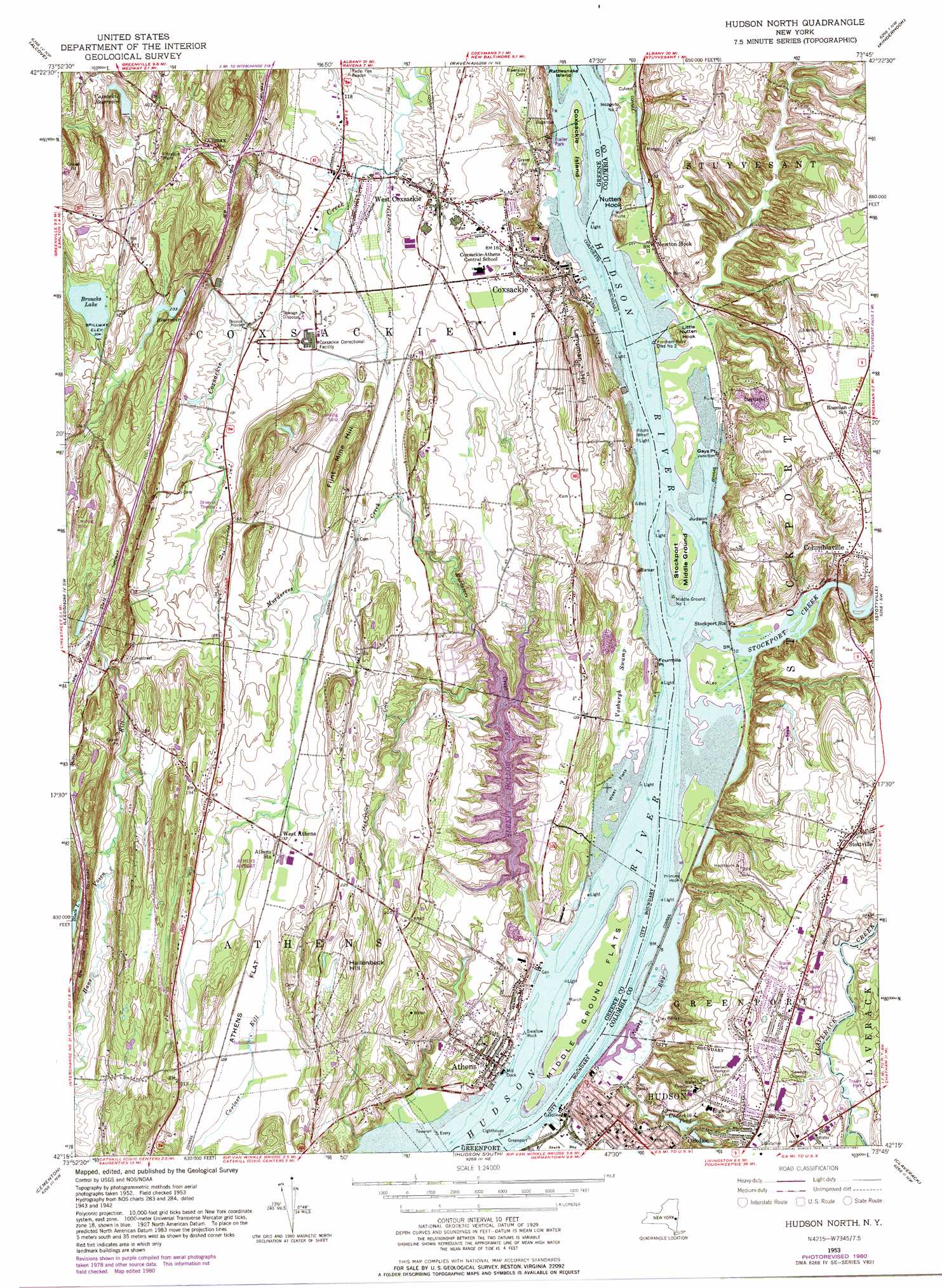
USGS Topo Quad 42073c7 - 1:24,000 scale
| Topo Map Name: | Hudson North |
| USGS Topo Quad ID: | 42073c7 |
| Print Size: | ca. 21 1/4" wide x 27" high |
| Southeast Coordinates: | 42.25° N latitude / 73.75° W longitude |
| Map Center Coordinates: | 42.3125° N latitude / 73.8125° W longitude |
| U.S. State: | NY |
| Filename: | o42073c7.jpg |
| Download Map JPG Image: | Hudson North topo map 1:24,000 scale |
| Map Type: | Topographic |
| Topo Series: | 7.5´ |
| Map Scale: | 1:24,000 |
| Source of Map Images: | United States Geological Survey (USGS) |
| Alternate Map Versions: |
Hudson North NY 1953, updated 1955 Download PDF Buy paper map Hudson North NY 1953, updated 1969 Download PDF Buy paper map Hudson North NY 1953, updated 1977 Download PDF Buy paper map Hudson North NY 1980, updated 1981 Download PDF Buy paper map Hudson North NY 2010 Download PDF Buy paper map Hudson North NY 2013 Download PDF Buy paper map Hudson North NY 2016 Download PDF Buy paper map |
1:24,000 Topo Quads surrounding Hudson North
Westerlo |
Clarksville |
Delmar |
East Greenbush |
Nassau |
Greenville |
Alcove |
Ravena |
Kinderhook |
East Chatham |
Freehold |
Leeds |
Hudson North |
Stottville |
Chatham |
Kaaterskill |
Cementon |
Hudson South |
Claverack |
Hillsdale |
Woodstock |
Saugerties |
Clermont |
Ancram |
Copake |
> Back to 42073a1 at 1:100,000 scale
> Back to 42072a1 at 1:250,000 scale
> Back to U.S. Topo Maps home
Hudson North topo map: Gazetteer
Hudson North: Airports
Athens Airport elevation 42m 137′Deer Run Airport elevation 106m 347′
Hudson North: Bars
Priming Hook elevation -1m -4′Hudson North: Bays
North Bay elevation 0m 0′Hudson North: Capes
Fourmile Point elevation 15m 49′Gays Point elevation 2m 6′
Judson Point elevation 4m 13′
Little Nutten Hook elevation 4m 13′
Nutten Hook elevation 9m 29′
Hudson North: Flats
Athens Flat elevation 39m 127′West Flats elevation -1m -4′
Hudson North: Islands
Coxsackie Island elevation 3m 9′Middle Ground Flats elevation 2m 6′
Stockport Middle Ground elevation 2m 6′
Hudson North: Lakes
Black Lake elevation 90m 295′Hudson North: Parks
Franklin Square elevation 10m 32′Washington Park elevation 29m 95′
Hudson North: Populated Places
Athens elevation 8m 26′Bronck House elevation 37m 121′
Climax elevation 75m 246′
Columbiaville elevation 43m 141′
Coxsackie elevation 43m 141′
Dutch Village Mobile Home Park elevation 43m 141′
Hudson elevation 25m 82′
Jo-nel Mobile Home Park elevation 51m 167′
Lorenz Park elevation 55m 180′
Newton Hook elevation 5m 16′
Oakdale elevation 33m 108′
West Athens elevation 39m 127′
West Coxsackie elevation 40m 131′
Hudson North: Post Offices
Athens Post Office elevation 3m 9′Hudson North: Reservoirs
Broncks Lake elevation 92m 301′Coxsackie Reservoir elevation 122m 400′
Sleepy Hollow Lake elevation 19m 62′
Underhill Pond elevation 23m 75′
Hudson North: Streams
Murderers Creek elevation 0m 0′Stockport Creek elevation 0m 0′
Hudson North: Summits
Flint Mine Hill elevation 90m 295′Hallenbeck Hill elevation 92m 301′
Lampman Hill elevation 80m 262′
Parade Hill elevation 25m 82′
Hudson North: Swamps
Vosburgh Swamp elevation 1m 3′Hudson North digital topo map on disk
Buy this Hudson North topo map showing relief, roads, GPS coordinates and other geographical features, as a high-resolution digital map file on DVD:
New York, Vermont, Connecticut & Western Massachusetts
Buy digital topo maps: New York, Vermont, Connecticut & Western Massachusetts