Peru Topo Map Massachusetts
To zoom in, hover over the map of Peru
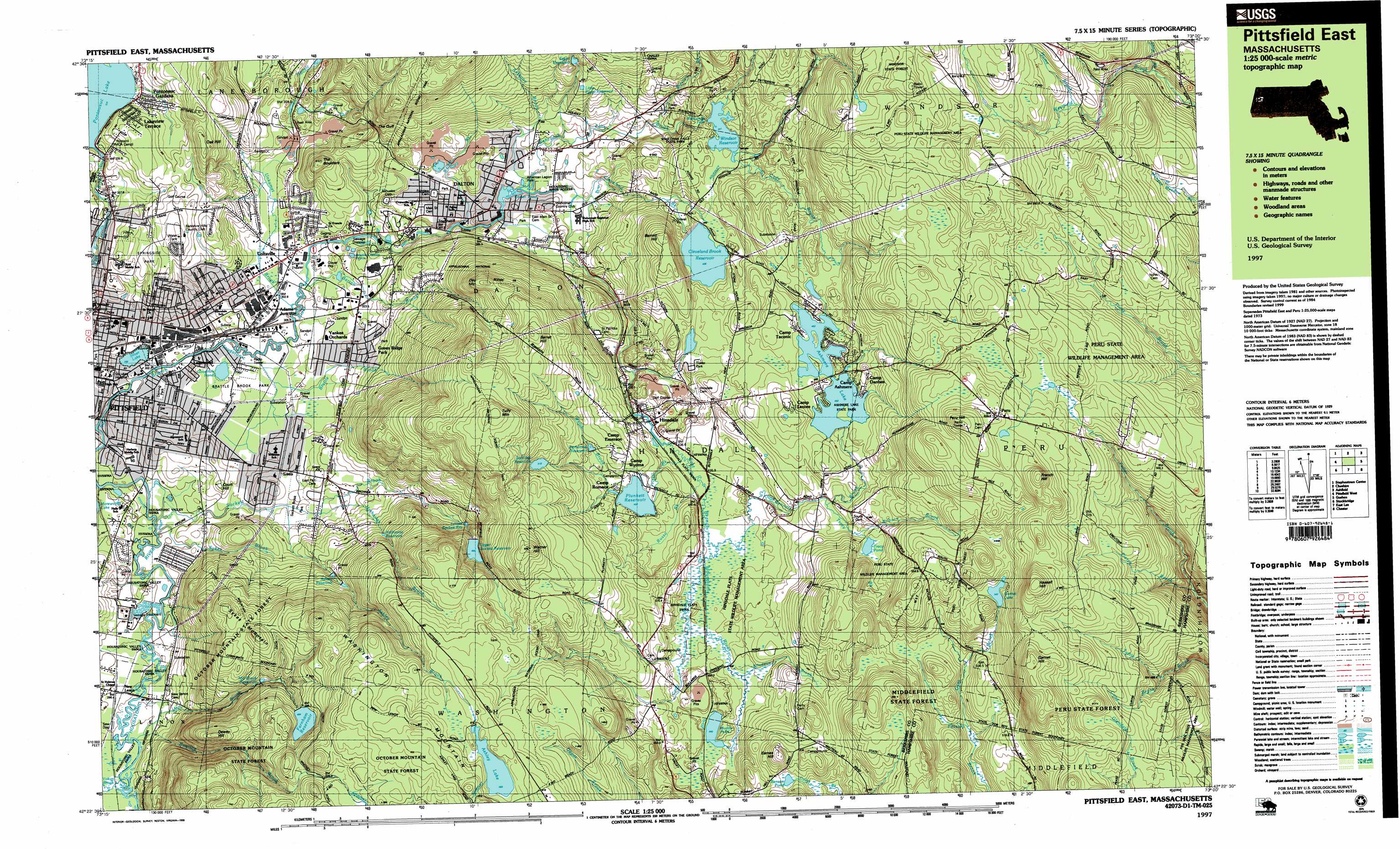
USGS Topo Quad 42073d1 - 1:25,000 scale
| Topo Map Name: | Peru |
| USGS Topo Quad ID: | 42073d1 |
| Print Size: | ca. 39" wide x 24" high |
| Southeast Coordinates: | 42.375° N latitude / 73° W longitude |
| Map Center Coordinates: | 42.4375° N latitude / 73.125° W longitude |
| U.S. State: | MA |
| Filename: | k42073d1.jpg |
| Download Map JPG Image: | Peru topo map 1:25,000 scale |
| Map Type: | Topographic |
| Topo Series: | 7.5´x15´ |
| Map Scale: | 1:25,000 |
| Source of Map Images: | United States Geological Survey (USGS) |
| Alternate Map Versions: |
Pittsfield East MA 1988, updated 1988 Download PDF Buy paper map Pittsfield East MA 1997, updated 1999 Download PDF Buy paper map |
1:24,000 Topo Quads surrounding Peru
Berlin |
North Adams |
Heath |
||
Hancock |
Windsor |
Ashfield |
||
Pittsfield West |
Peru |
Goshen |
||
Stockbridge |
Becket |
Westhampton |
||
Great Barrington |
Otis |
Woronoco |
> Back to 42073a1 at 1:100,000 scale
> Back to 42072a1 at 1:250,000 scale
> Back to U.S. Topo Maps home
Peru topo map: Gazetteer
Peru: Airports
Advance Materials Corp Heliport elevation 307m 1007′Blueberry Hill Airport elevation 606m 1988′
Peru: Dams
Ashmere Lake Dam elevation 482m 1581′Bel Air Dam elevation 313m 1026′
Belmont Reservoir Dam elevation 519m 1702′
Byron Weston Dam elevation 346m 1135′
Cleveland Brook Reservoir Dam elevation 429m 1407′
Egypt Reservoir Dam elevation 446m 1463′
Government Mill Dam elevation 316m 1036′
Old Berkshire Mill Dam elevation 354m 1161′
Pontoosuc Lake Dam elevation 330m 1082′
Windsor Reservoir Dam elevation 441m 1446′
Peru: Falls
Wahconah Falls elevation 440m 1443′Peru: Forests
Peru State Forest elevation 601m 1971′Peru: Gaps
The Gulf elevation 370m 1213′Peru: Lakes
Benson Pond elevation 497m 1630′Goodrich Pond elevation 302m 990′
Muddy Pond elevation 440m 1443′
Silver Lake elevation 298m 977′
Tracy Pond elevation 472m 1548′
Peru: Parks
American Legion Park elevation 347m 1138′Berkshire County Softball Complex elevation 306m 1003′
Brattle Brook Park elevation 305m 1000′
Canoe Meadows Wildlife Sanctuary elevation 298m 977′
Deming Park elevation 303m 994′
Frances Rice Wildlife Refuge elevation 602m 1975′
Henry V Marchisio Memorial Park elevation 311m 1020′
Peru State Wildlife Management Area elevation 581m 1906′
Pine Grove Park elevation 354m 1161′
Pittsfield State Watershed Area elevation 425m 1394′
Sackett Brook Park elevation 314m 1030′
Springside Park elevation 351m 1151′
Stritch Sculpture Garden elevation 479m 1571′
Wahconah Falls State Park elevation 393m 1289′
Peru: Populated Places
Adams Junction elevation 304m 997′Beechwood Estates elevation 440m 1443′
Camp Ashmere elevation 482m 1581′
Camp Danbee elevation 490m 1607′
Camp Emerson elevation 487m 1597′
Camp Lenore elevation 512m 1679′
Camp Merrill elevation 355m 1164′
Camp Romaca elevation 462m 1515′
Camp Sumner elevation 367m 1204′
Camp Taconic elevation 486m 1594′
Camp Wyoma elevation 462m 1515′
Coltsville elevation 304m 997′
Dalton elevation 348m 1141′
Green Ridge Park elevation 328m 1076′
Hinsdale elevation 436m 1430′
Lakeview Terrace elevation 352m 1154′
Lakewood elevation 306m 1003′
New Lenox elevation 294m 964′
Peru elevation 625m 2050′
Pittsfield elevation 306m 1003′
Pontoosuc elevation 331m 1085′
Pontoosuc Gardens elevation 341m 1118′
The Boulders elevation 318m 1043′
Victory Hill elevation 376m 1233′
Yankee Orchards elevation 313m 1026′
Peru: Post Offices
Dalton Post Office elevation 341m 1118′Hinsdale Post Office elevation 436m 1430′
Pittsfield Post Office elevation 313m 1026′
Peru: Reservoirs
Ashley Lake elevation 582m 1909′Ashley Reservoir elevation 396m 1299′
Ashmere Lake elevation 482m 1581′
Belmont Reservoir elevation 519m 1702′
Center Pond elevation 346m 1135′
Cleveland Brook Reservoir elevation 429m 1407′
East Branch Housatonic River Reservoir elevation 354m 1161′
Egypt Reservoir elevation 446m 1463′
Farnham Reservoir elevation 484m 1587′
Fernwood Reservoir elevation 474m 1555′
Garnet Lake elevation 539m 1768′
Hathaway Reservoir elevation 394m 1292′
Little Egypt Reservoir elevation 449m 1473′
Lower Sackett Reservoir elevation 395m 1295′
Mill Brook Reservoir elevation 408m 1338′
Plunkett Reservoir elevation 459m 1505′
Pontoosuc Lake elevation 330m 1082′
Upper Sackett Reservoir elevation 465m 1525′
West Branch Housatonic River Reservoir elevation 313m 1026′
Windsor Reservoir elevation 441m 1446′
Peru: Ridges
Washington Mountain elevation 306m 1003′Peru: Streams
Anthony Brook elevation 348m 1141′Ashley Brook elevation 310m 1017′
Barton Brook elevation 301m 987′
Bennett Brook elevation 437m 1433′
Bilodeau Brook elevation 437m 1433′
Brattle Brook elevation 297m 974′
Cady Brook elevation 442m 1450′
Cady Brook elevation 436m 1430′
Cleveland Brook elevation 350m 1148′
Cone Brook elevation 479m 1571′
Frisell Brook elevation 436m 1430′
Geer Brook elevation 455m 1492′
Hathaway Brook elevation 315m 1033′
Hume Brook elevation 530m 1738′
Kilburn Brook elevation 460m 1509′
Mill Brook elevation 293m 961′
Pierce Brook elevation 405m 1328′
Roaring Brook elevation 291m 954′
Russo Brook elevation 436m 1430′
Sackett Brook elevation 293m 961′
Shaw Brook elevation 476m 1561′
Sykes Brook elevation 293m 961′
Tracy Brook elevation 460m 1509′
Unkamet Brook elevation 299m 980′
Wahconah Falls Brook elevation 349m 1145′
Walker Brook elevation 329m 1079′
Welsh Brook elevation 462m 1515′
Weston Brook elevation 372m 1220′
Windsor Brook elevation 441m 1446′
Yokun Brook elevation 290m 951′
Peru: Summits
Barret Hill elevation 573m 1879′Barrett Hill elevation 519m 1702′
Court Hill elevation 326m 1069′
Day Mountain elevation 546m 1791′
Dewey Hill elevation 511m 1676′
Eames Hill elevation 556m 1824′
French Hill elevation 675m 2214′
Garnet Hill elevation 663m 2175′
Haskell Hill elevation 680m 2230′
Main Street Cemetery elevation 352m 1154′
Oak Hill elevation 424m 1391′
Peru Hill elevation 662m 2171′
Sykes Mountain elevation 524m 1719′
The Boulders elevation 409m 1341′
Tully Mountain elevation 631m 2070′
Warner Hill elevation 627m 2057′
Peru digital topo map on disk
Buy this Peru topo map showing relief, roads, GPS coordinates and other geographical features, as a high-resolution digital map file on DVD:
New York, Vermont, Connecticut & Western Massachusetts
Buy digital topo maps: New York, Vermont, Connecticut & Western Massachusetts