Albany Topo Map New York
To zoom in, hover over the map of Albany
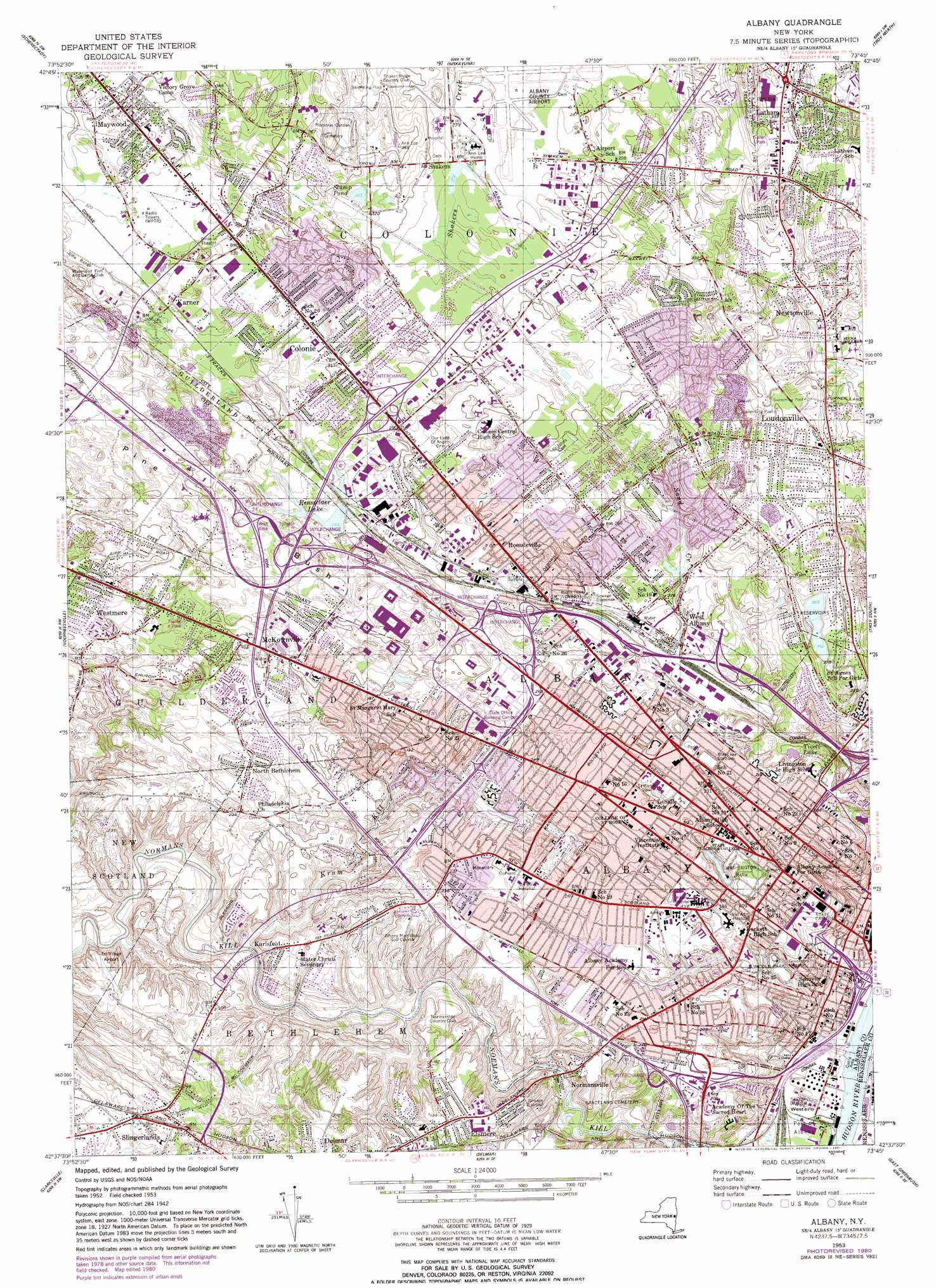
USGS Topo Quad 42073f7 - 1:24,000 scale
| Topo Map Name: | Albany |
| USGS Topo Quad ID: | 42073f7 |
| Print Size: | ca. 21 1/4" wide x 27" high |
| Southeast Coordinates: | 42.625° N latitude / 73.75° W longitude |
| Map Center Coordinates: | 42.6875° N latitude / 73.8125° W longitude |
| U.S. State: | NY |
| Filename: | o42073f7.jpg |
| Download Map JPG Image: | Albany topo map 1:24,000 scale |
| Map Type: | Topographic |
| Topo Series: | 7.5´ |
| Map Scale: | 1:24,000 |
| Source of Map Images: | United States Geological Survey (USGS) |
| Alternate Map Versions: |
Albany NY 1953, updated 1956 Download PDF Buy paper map Albany NY 1953, updated 1965 Download PDF Buy paper map Albany NY 1953, updated 1981 Download PDF Buy paper map Albany NY 1978, updated 1982 Download PDF Buy paper map Albany NY 1994, updated 2000 Download PDF Buy paper map Albany NY 2010 Download PDF Buy paper map Albany NY 2013 Download PDF Buy paper map Albany NY 2016 Download PDF Buy paper map |
1:24,000 Topo Quads surrounding Albany
Pattersonville |
Burnt Hills |
Round Lake |
Mechanicville |
Schaghticoke |
Rotterdam Junction |
Schenectady |
Niskayuna |
Troy North |
Tomhannock |
Altamont |
Voorheesville |
Albany |
Troy South |
Averill Park |
Westerlo |
Clarksville |
Delmar |
East Greenbush |
Nassau |
Greenville |
Alcove |
Ravena |
Kinderhook |
East Chatham |
> Back to 42073e1 at 1:100,000 scale
> Back to 42072a1 at 1:250,000 scale
> Back to U.S. Topo Maps home
Albany topo map: Gazetteer
Albany: Airports
Albany County Airport elevation 84m 275′AMCH Heliport elevation 60m 196′
New York Army National Guard Heliport elevation 59m 193′
Tri Village Airport elevation 63m 206′
Albany: Bridges
Collar City Bridge elevation 96m 314′Albany: Crossings
Interchange 23 elevation 62m 203′Interchange 24 elevation 86m 282′
Interchange Four elevation 62m 203′
Interchange One elevation 73m 239′
Interchange Three elevation 76m 249′
Interchange Two elevation 92m 301′
Albany: Flats
Westerlo Island elevation 6m 19′Albany: Lakes
Rensselaer Lake elevation 79m 259′Stump Pond elevation 98m 321′
Tivoli Lake elevation 43m 141′
Albany: Parks
Academy Park elevation 45m 147′Bleecker Stadium elevation 73m 239′
Capitol Park elevation 53m 173′
Collins Circle elevation 80m 262′
Delaware Square elevation 62m 203′
Dudley Park elevation 62m 203′
Heritage Park elevation 89m 291′
Liberty Park elevation 6m 19′
Lincoln Park elevation 43m 141′
McKownville Park elevation 64m 209′
Newtonville Park elevation 117m 383′
Saint Joseph's Park elevation 33m 108′
Saint Marys Park elevation 64m 209′
Schuetzen Park elevation 79m 259′
Sheridan Park elevation 41m 134′
Swinburne Park elevation 75m 246′
Townsend Park elevation 65m 213′
Van Rensselaer Park elevation 37m 121′
Washington Park elevation 60m 196′
Westland Hills Park elevation 80m 262′
Albany: Populated Places
Albany elevation 45m 147′Colonie elevation 95m 311′
Karlsfeld elevation 57m 187′
Karner elevation 99m 324′
Latham elevation 108m 354′
Latham Mobile Home Court elevation 103m 337′
Lincoln Park Homes elevation 19m 62′
Lone Pine Community Mobile Home Park elevation 98m 321′
Loudon Heights elevation 114m 374′
Loudonville elevation 106m 347′
Maywood elevation 95m 311′
McKownville elevation 76m 249′
Newtonville elevation 112m 367′
Normansville elevation 36m 118′
North Bethlehem elevation 71m 232′
Norton Street Mobile Home Park elevation 77m 252′
Roessleville elevation 74m 242′
Shakers elevation 83m 272′
Slingerlands elevation 67m 219′
Wackmans Mobile Home Park elevation 101m 331′
West Albany elevation 61m 200′
Westmere elevation 89m 291′
Albany: Reservoirs
Ann Lee Pond elevation 83m 272′Buckingham Lake elevation 64m 209′
Albany: Streams
Krum Kill elevation 27m 88′Sand Creek elevation 60m 196′
Albany: Woods
Pine Bush elevation 96m 314′Albany digital topo map on disk
Buy this Albany topo map showing relief, roads, GPS coordinates and other geographical features, as a high-resolution digital map file on DVD:
New York, Vermont, Connecticut & Western Massachusetts
Buy digital topo maps: New York, Vermont, Connecticut & Western Massachusetts