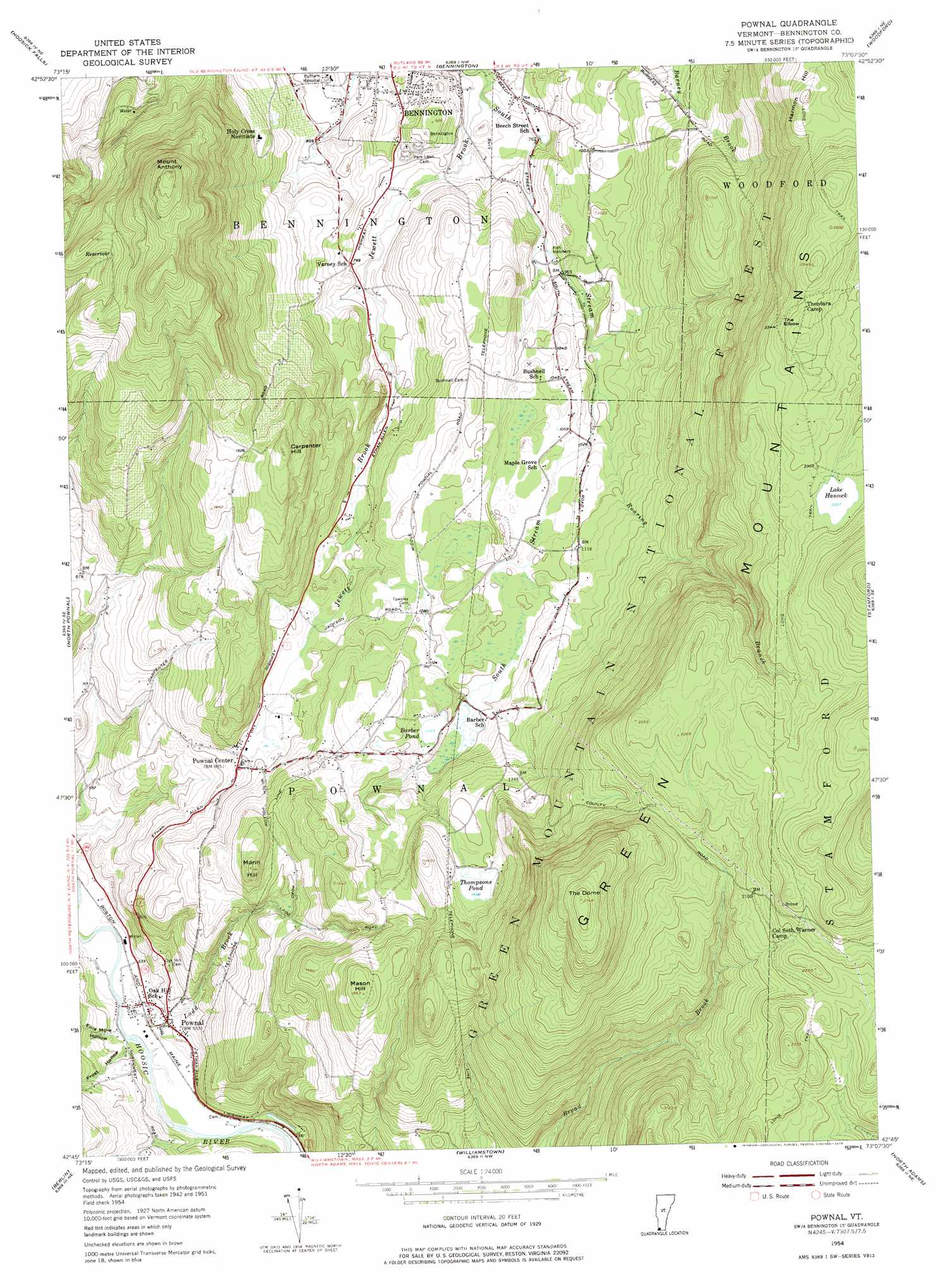
Pownal Topo Map Vermont
To zoom in, hover over the map of Pownal
USGS Topo Quad 42073g2 - 1:24,000 scale
| Topo Map Name: | Pownal |
| USGS Topo Quad ID: | 42073g2 |
| Print Size: | ca. 21 1/4" wide x 27" high |
| Southeast Coordinates: | 42.75° N latitude / 73.125° W longitude |
| Map Center Coordinates: | 42.8125° N latitude / 73.1875° W longitude |
| U.S. State: | VT |
| Filename: | o42073g2.jpg |
| Download Map JPG Image: | Pownal topo map 1:24,000 scale |
| Map Type: | Topographic |
| Topo Series: | 7.5´ |
| Map Scale: | 1:24,000 |
| Source of Map Images: | United States Geological Survey (USGS) |
| Alternate Map Versions: |
Pownal VT 1954, updated 1957 Download PDF Buy paper map Pownal VT 1954, updated 1965 Download PDF Buy paper map Pownal VT 1954, updated 1975 Download PDF Buy paper map Pownal VT 1954, updated 1975 Download PDF Buy paper map Pownal VT 1997, updated 2000 Download PDF Buy paper map Pownal VT 2012 Download PDF Buy paper map Pownal VT 2015 Download PDF Buy paper map |
| FStopo: | US Forest Service topo Pownal is available: Download FStopo PDF Download FStopo TIF |
1:24,000 Topo Quads surrounding Pownal
Cambridge |
Shushan |
Arlington |
Sunderland |
Stratton Mountain |
Eagle Bridge |
Hoosick Falls |
Bennington |
Woodford |
Mount Snow |
Grafton |
North Pownal |
Pownal |
Stamford |
Readsboro |
Berlin |
North Adams |
|||
Hancock |
Windsor |
> Back to 42073e1 at 1:100,000 scale
> Back to 42072a1 at 1:250,000 scale
> Back to U.S. Topo Maps home
Pownal topo map: Gazetteer
Pownal: Dams
Barber Pond Dam elevation 336m 1102′South Stream Dam elevation 330m 1082′
Thompsons Pond Upper Dam elevation 428m 1404′
Pownal: Forests
Bennington Municipal Forest elevation 316m 1036′Pownal: Lakes
Lake Hancock elevation 691m 2267′Pownal: Parks
South Stream Waterfowl Area elevation 333m 1092′Pownal: Populated Places
Cozy Meadow Mobile Home Park elevation 292m 958′Pownal elevation 179m 587′
Pownal Center elevation 296m 971′
Pownal: Post Offices
Pownal Post Office elevation 169m 554′Pownal: Reservoirs
Barber Pond elevation 336m 1102′South Stream Pond elevation 333m 1092′
South Stream Pond elevation 330m 1082′
Thompsons Pond elevation 428m 1404′
Pownal: Streams
Jewett Brook elevation 225m 738′Ladd Brook elevation 162m 531′
Roaring Branch elevation 301m 987′
South Stream elevation 225m 738′
Pownal: Summits
Carpenter Hill elevation 514m 1686′Harmon Hill elevation 708m 2322′
Mann Hill elevation 429m 1407′
Mason Hill elevation 505m 1656′
Mount Anthony elevation 715m 2345′
The Dome elevation 836m 2742′
Pownal: Valleys
Ellis Mine Hollow elevation 169m 554′Frost Hollow elevation 166m 544′
Lincoln Hollow elevation 164m 538′
Pownal digital topo map on disk
Buy this Pownal topo map showing relief, roads, GPS coordinates and other geographical features, as a high-resolution digital map file on DVD:
New York, Vermont, Connecticut & Western Massachusetts
Buy digital topo maps: New York, Vermont, Connecticut & Western Massachusetts