Harpersfield Topo Map New York
To zoom in, hover over the map of Harpersfield
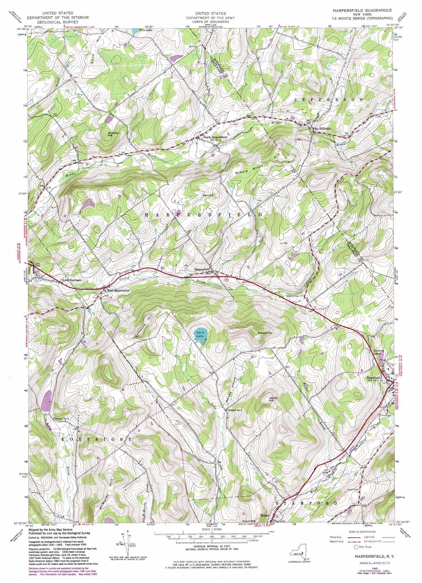
USGS Topo Quad 42074d6 - 1:24,000 scale
| Topo Map Name: | Harpersfield |
| USGS Topo Quad ID: | 42074d6 |
| Print Size: | ca. 21 1/4" wide x 27" high |
| Southeast Coordinates: | 42.375° N latitude / 74.625° W longitude |
| Map Center Coordinates: | 42.4375° N latitude / 74.6875° W longitude |
| U.S. State: | NY |
| Filename: | o42074d6.jpg |
| Download Map JPG Image: | Harpersfield topo map 1:24,000 scale |
| Map Type: | Topographic |
| Topo Series: | 7.5´ |
| Map Scale: | 1:24,000 |
| Source of Map Images: | United States Geological Survey (USGS) |
| Alternate Map Versions: |
Harpersfield NY 1945, updated 1960 Download PDF Buy paper map Harpersfield NY 1945, updated 1971 Download PDF Buy paper map Harpersfield NY 1982, updated 1983 Download PDF Buy paper map Harpersfield NY 2010 Download PDF Buy paper map Harpersfield NY 2013 Download PDF Buy paper map Harpersfield NY 2016 Download PDF Buy paper map |
1:24,000 Topo Quads surrounding Harpersfield
Cooperstown |
Westford |
South Valley |
Richmondville |
Cobleskill |
Milford |
Schenevus |
Charlotteville |
Summit |
Breakabeen |
West Davenport |
Davenport |
Harpersfield |
Stamford |
Gilboa |
Delhi |
Bloomville |
Hobart |
Roxbury |
Prattsville |
Hamden |
Andes |
Margaretville |
Fleischmanns |
West Kill |
> Back to 42074a1 at 1:100,000 scale
> Back to 42074a1 at 1:250,000 scale
> Back to U.S. Topo Maps home
Harpersfield topo map: Gazetteer
Harpersfield: Lakes
Odell Lake elevation 625m 2050′Rexmere Lakes elevation 557m 1827′
Harpersfield: Populated Places
Harpersfield elevation 508m 1666′North Harpersfield elevation 486m 1594′
North Kortright elevation 472m 1548′
West Harpersfield elevation 481m 1578′
West Jefferson elevation 513m 1683′
Harpersfield: Streams
Basset Brook elevation 514m 1686′Harpersfield: Summits
Fan Hill elevation 650m 2132′Gunhouse Hill elevation 720m 2362′
Jaclyn Hill elevation 729m 2391′
Middle Brook Hill elevation 668m 2191′
Mount Bob elevation 613m 2011′
Peters Hill elevation 769m 2522′
Streeter Hill elevation 604m 1981′
Titus Hill elevation 636m 2086′
Harpersfield: Valleys
Whisky Hollow elevation 535m 1755′Harpersfield digital topo map on disk
Buy this Harpersfield topo map showing relief, roads, GPS coordinates and other geographical features, as a high-resolution digital map file on DVD:
New York, Vermont, Connecticut & Western Massachusetts
Buy digital topo maps: New York, Vermont, Connecticut & Western Massachusetts