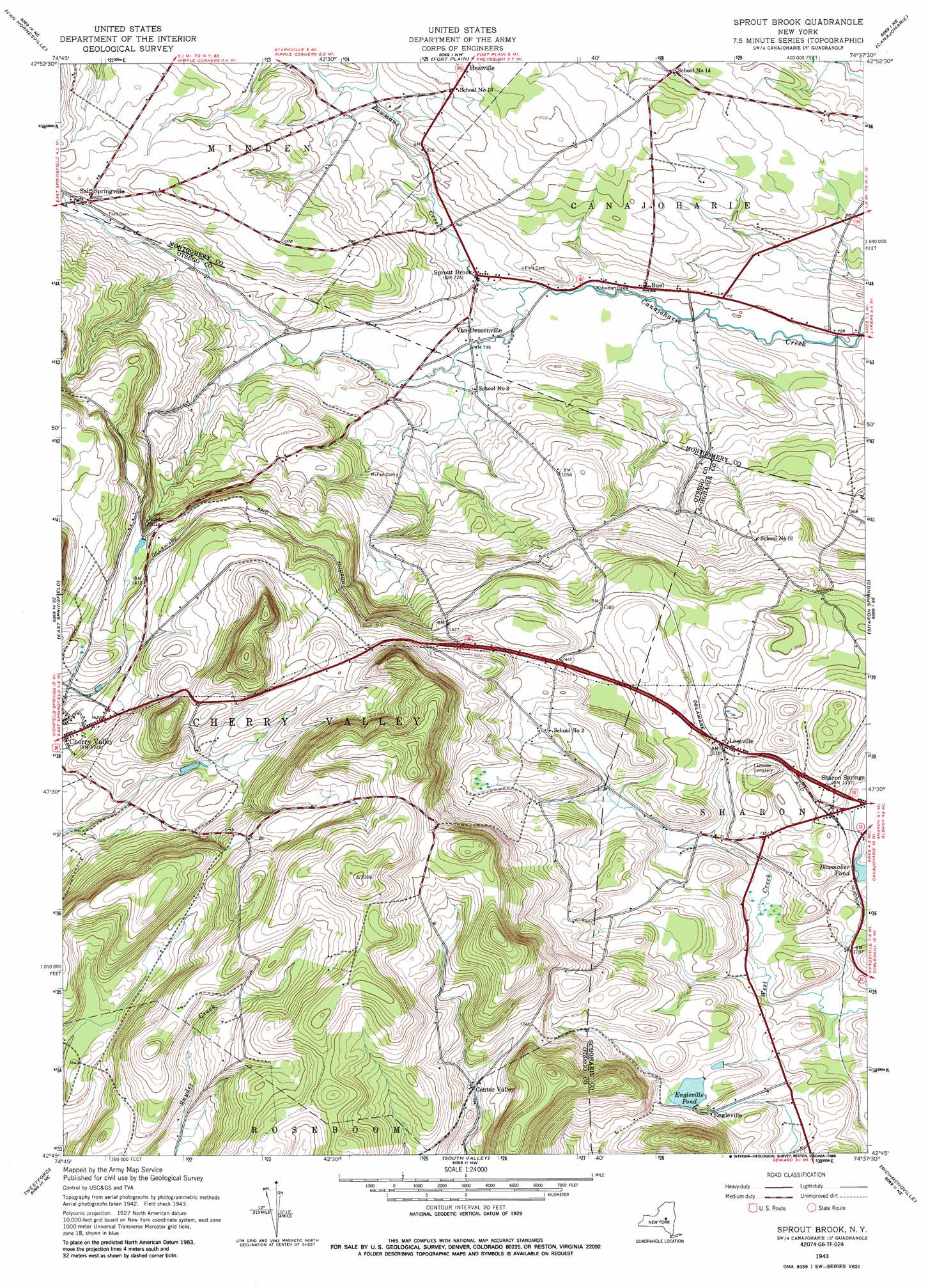
Sprout Brook Topo Map New York
To zoom in, hover over the map of Sprout Brook
USGS Topo Quad 42074g6 - 1:24,000 scale
| Topo Map Name: | Sprout Brook |
| USGS Topo Quad ID: | 42074g6 |
| Print Size: | ca. 21 1/4" wide x 27" high |
| Southeast Coordinates: | 42.75° N latitude / 74.625° W longitude |
| Map Center Coordinates: | 42.8125° N latitude / 74.6875° W longitude |
| U.S. State: | NY |
| Filename: | o42074g6.jpg |
| Download Map JPG Image: | Sprout Brook topo map 1:24,000 scale |
| Map Type: | Topographic |
| Topo Series: | 7.5´ |
| Map Scale: | 1:24,000 |
| Source of Map Images: | United States Geological Survey (USGS) |
| Alternate Map Versions: |
Sprout Brook NY 1943, updated 1960 Download PDF Buy paper map Sprout Brook NY 1943, updated 1972 Download PDF Buy paper map Sprout Brook NY 1943, updated 1988 Download PDF Buy paper map Sprout Brook NY 2010 Download PDF Buy paper map Sprout Brook NY 2013 Download PDF Buy paper map Sprout Brook NY 2016 Download PDF Buy paper map |
1:24,000 Topo Quads surrounding Sprout Brook
Herkimer |
Little Falls |
Oppenheim |
Lassellsville |
Peck Lake |
Jordanville |
Van Hornesville |
Fort Plain |
Canajoharie |
Randall |
Richfield Springs |
East Springfield |
Sprout Brook |
Sharon Springs |
Carlisle |
Cooperstown |
Westford |
South Valley |
Richmondville |
Cobleskill |
Milford |
Schenevus |
Charlotteville |
Summit |
Breakabeen |
> Back to 42074e1 at 1:100,000 scale
> Back to 42074a1 at 1:250,000 scale
> Back to U.S. Topo Maps home
Sprout Brook topo map: Gazetteer
Sprout Brook: Falls
Judds Falls elevation 368m 1207′Sprout Brook: Populated Places
Buel elevation 221m 725′Center Valley elevation 499m 1637′
Engleville elevation 413m 1354′
Hessville elevation 285m 935′
Leesville elevation 408m 1338′
Salt Springville elevation 302m 990′
Sprout Brook elevation 220m 721′
Van Deusenville elevation 223m 731′
Sprout Brook: Reservoirs
Engleville Pond elevation 433m 1420′Sprout Brook: Streams
Bowmans Creek elevation 218m 715′Sprout Brook digital topo map on disk
Buy this Sprout Brook topo map showing relief, roads, GPS coordinates and other geographical features, as a high-resolution digital map file on DVD:
New York, Vermont, Connecticut & Western Massachusetts
Buy digital topo maps: New York, Vermont, Connecticut & Western Massachusetts