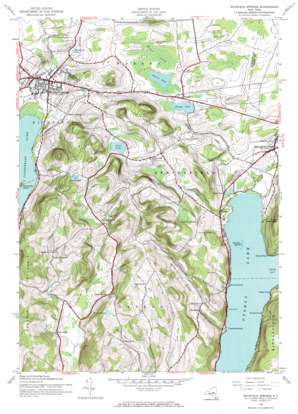
Richfield Springs Topo Map New York
To zoom in, hover over the map of Richfield Springs
USGS Topo Quad 42074g8 - 1:24,000 scale
| Topo Map Name: | Richfield Springs |
| USGS Topo Quad ID: | 42074g8 |
| Print Size: | ca. 21 1/4" wide x 27" high |
| Southeast Coordinates: | 42.75° N latitude / 74.875° W longitude |
| Map Center Coordinates: | 42.8125° N latitude / 74.9375° W longitude |
| U.S. State: | NY |
| Filename: | o42074g8.jpg |
| Download Map JPG Image: | Richfield Springs topo map 1:24,000 scale |
| Map Type: | Topographic |
| Topo Series: | 7.5´ |
| Map Scale: | 1:24,000 |
| Source of Map Images: | United States Geological Survey (USGS) |
| Alternate Map Versions: |
Richfield Springs NY 1943, updated 1960 Download PDF Buy paper map Richfield Springs NY 1943, updated 1968 Download PDF Buy paper map Richfield Springs NY 2010 Download PDF Buy paper map Richfield Springs NY 2013 Download PDF Buy paper map Richfield Springs NY 2016 Download PDF Buy paper map |
1:24,000 Topo Quads surrounding Richfield Springs
> Back to 42074e1 at 1:100,000 scale
> Back to 42074a1 at 1:250,000 scale
> Back to U.S. Topo Maps home
Richfield Springs topo map: Gazetteer
Richfield Springs: Airports
Richfield Airport elevation 421m 1381′Richfield Springs: Capes
Clarke Point elevation 377m 1236′Fivemile Point elevation 364m 1194′
Gravelly Point elevation 371m 1217′
Hutter Point elevation 363m 1190′
Peggs Point elevation 370m 1213′
Sixmile Point elevation 363m 1190′
Richfield Springs: Islands
Deowongo Island elevation 397m 1302′Sunken Island elevation 363m 1190′
Richfield Springs: Lakes
Bailey Pond elevation 504m 1653′Muskrat Pond elevation 555m 1820′
Otsego Lake elevation 363m 1190′
Weaver Lake elevation 411m 1348′
Young Lake elevation 410m 1345′
Richfield Springs: Parks
Cary Park elevation 445m 1459′Richfield Springs: Populated Places
Pierstown elevation 435m 1427′Richfield Springs elevation 400m 1312′
Springfield Center elevation 384m 1259′
Taylortown elevation 424m 1391′
Warren elevation 418m 1371′
Richfield Springs: Reservoirs
Allen Lake elevation 503m 1650′Clarke Pond elevation 368m 1207′
Weatherby Pond elevation 403m 1322′
Richfield Springs: Streams
Cripple Creek elevation 365m 1197′Hayden Creek elevation 365m 1197′
Ocquionis Creek elevation 387m 1269′
Richfield Springs: Summits
Fitch Hill elevation 562m 1843′King Hill elevation 572m 1876′
Metcalf Hill elevation 598m 1961′
Panther Mountain elevation 599m 1965′
Red House Hill elevation 490m 1607′
Rum Hill elevation 641m 2103′
Richfield Springs: Swamps
Maumee Swamp elevation 419m 1374′Richfield Springs: Valleys
Mohican Canyon elevation 363m 1190′Wedderspoon Hollow elevation 442m 1450′
Richfield Springs digital topo map on disk
Buy this Richfield Springs topo map showing relief, roads, GPS coordinates and other geographical features, as a high-resolution digital map file on DVD:
New York, Vermont, Connecticut & Western Massachusetts
Buy digital topo maps: New York, Vermont, Connecticut & Western Massachusetts


