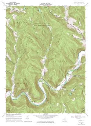
Corbett Topo Map New York
To zoom in, hover over the map of Corbett
USGS Topo Quad 42075a1 - 1:24,000 scale
| Topo Map Name: | Corbett |
| USGS Topo Quad ID: | 42075a1 |
| Print Size: | ca. 21 1/4" wide x 27" high |
| Southeast Coordinates: | 42° N latitude / 75° W longitude |
| Map Center Coordinates: | 42.0625° N latitude / 75.0625° W longitude |
| U.S. State: | NY |
| Filename: | o42075a1.jpg |
| Download Map JPG Image: | Corbett topo map 1:24,000 scale |
| Map Type: | Topographic |
| Topo Series: | 7.5´ |
| Map Scale: | 1:24,000 |
| Source of Map Images: | United States Geological Survey (USGS) |
| Alternate Map Versions: |
Corbett NY 1965, updated 1966 Download PDF Buy paper map Corbett NY 1965, updated 1974 Download PDF Buy paper map Corbett NY 1965, updated 1974 Download PDF Buy paper map Corbett NY 2010 Download PDF Buy paper map Corbett NY 2013 Download PDF Buy paper map Corbett NY 2016 Download PDF Buy paper map |
1:24,000 Topo Quads surrounding Corbett
> Back to 42075a1 at 1:100,000 scale
> Back to 42074a1 at 1:250,000 scale
> Back to U.S. Topo Maps home
Corbett topo map: Gazetteer
Corbett: Airports
Downsville Airport elevation 423m 1387′Corbett: Lakes
Bear Cub Pond elevation 615m 2017′Quinn Lake elevation 520m 1706′
Russ Gray Pond elevation 600m 1968′
Stuart Lake elevation 470m 1541′
Corbett: Mines
Mahoney Quarry elevation 662m 2171′Corbett: Parks
Bear Spring Mountain Game Management Area elevation 695m 2280′Corbett: Populated Places
Corbett elevation 338m 1108′Gregorytown elevation 338m 1108′
Harvard elevation 316m 1036′
Long Flat elevation 320m 1049′
Shinhopple elevation 324m 1062′
Corbett: Reservoirs
Launt Pond elevation 574m 1883′Corbett: Streams
Ash Run elevation 334m 1095′Baxter Brook elevation 308m 1010′
Bear Brook elevation 433m 1420′
Campbell Brook elevation 324m 1062′
Carcass Brook elevation 371m 1217′
Clauson Brook elevation 308m 1010′
Dry Brook elevation 326m 1069′
East Trout Brook elevation 391m 1282′
Gee Brook elevation 340m 1115′
Little Fuller Brook elevation 461m 1512′
Mellis Brook elevation 394m 1292′
Pine Mountain Branch elevation 393m 1289′
Trout Brook elevation 317m 1040′
Tub Mill Brook elevation 358m 1174′
West Trout Brook elevation 391m 1282′
Corbett: Summits
Baxter Mountain elevation 614m 2014′Brace Hill elevation 752m 2467′
Fork Mountain elevation 741m 2431′
Trout Brook Mountain elevation 688m 2257′
Twadell Mountain elevation 699m 2293′
Corbett: Valleys
Barney Hollow elevation 335m 1099′Fuller Hollow elevation 331m 1085′
Granger Hollow elevation 493m 1617′
Gregory Hollow elevation 341m 1118′
Hog Hollow elevation 349m 1145′
Lindsley Hollow elevation 445m 1459′
Mills Hollow elevation 334m 1095′
Notch Hollow elevation 452m 1482′
Possession Hollow elevation 366m 1200′
Thayer Hollow elevation 325m 1066′
Corbett digital topo map on disk
Buy this Corbett topo map showing relief, roads, GPS coordinates and other geographical features, as a high-resolution digital map file on DVD:
New York, Vermont, Connecticut & Western Massachusetts
Buy digital topo maps: New York, Vermont, Connecticut & Western Massachusetts


