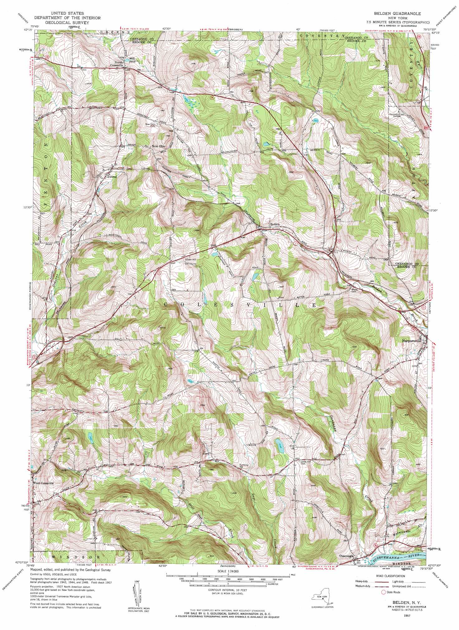
Belden Topo Map New York
To zoom in, hover over the map of Belden
USGS Topo Quad 42075b6 - 1:24,000 scale
| Topo Map Name: | Belden |
| USGS Topo Quad ID: | 42075b6 |
| Print Size: | ca. 21 1/4" wide x 27" high |
| Southeast Coordinates: | 42.125° N latitude / 75.625° W longitude |
| Map Center Coordinates: | 42.1875° N latitude / 75.6875° W longitude |
| U.S. State: | NY |
| Filename: | o42075b6.jpg |
| Download Map JPG Image: | Belden topo map 1:24,000 scale |
| Map Type: | Topographic |
| Topo Series: | 7.5´ |
| Map Scale: | 1:24,000 |
| Source of Map Images: | United States Geological Survey (USGS) |
| Alternate Map Versions: |
Belden NY 1957, updated 1959 Download PDF Buy paper map Belden NY 2010 Download PDF Buy paper map Belden NY 2013 Download PDF Buy paper map Belden NY 2016 Download PDF Buy paper map |
1:24,000 Topo Quads surrounding Belden
Willet |
Smithville Flats |
Tyner |
Oxford |
Guilford |
Whitney Point |
Greene |
Brisben |
West Bainbridge |
Sidney |
Castle Creek |
Chenango Forks |
Belden |
Afton |
North Sanford |
Binghamton West |
Binghamton East |
Windsor |
Gulf Summit |
Deposit |
Laurel Lake |
Franklin Forks |
Great Bend |
Susquehanna |
Starrucca |
> Back to 42075a1 at 1:100,000 scale
> Back to 42074a1 at 1:250,000 scale
> Back to U.S. Topo Maps home
Belden topo map: Gazetteer
Belden: Lakes
Mill Pond elevation 407m 1335′Belden: Populated Places
Belden elevation 392m 1286′Belden Hill elevation 522m 1712′
Country Manor elevation 505m 1656′
Creekside Village elevation 309m 1013′
Flannerys Mobile Home Park elevation 480m 1574′
New Ohio elevation 490m 1607′
North Colesville elevation 420m 1377′
Ouaquaga elevation 288m 944′
Tunnel elevation 423m 1387′
West Colesville elevation 458m 1502′
Wooded Estates elevation 463m 1519′
Belden: Post Offices
Ouaquaga Post Office elevation 288m 944′Belden: Streams
Ouaquaga Creek elevation 280m 918′Watersnake Creek elevation 281m 921′
Belden digital topo map on disk
Buy this Belden topo map showing relief, roads, GPS coordinates and other geographical features, as a high-resolution digital map file on DVD:
New York, Vermont, Connecticut & Western Massachusetts
Buy digital topo maps: New York, Vermont, Connecticut & Western Massachusetts