Otego Topo Map New York
To zoom in, hover over the map of Otego
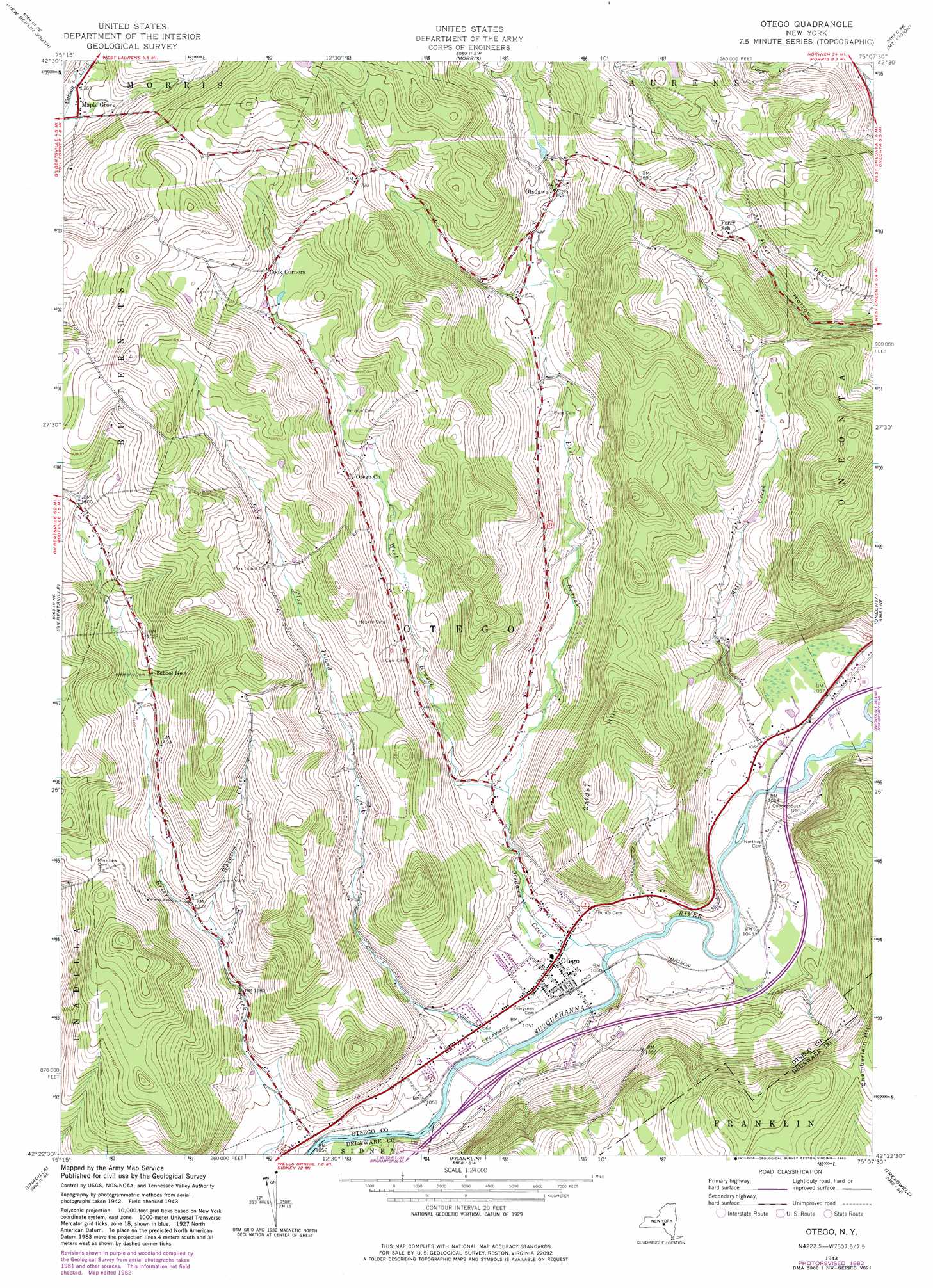
USGS Topo Quad 42075d2 - 1:24,000 scale
| Topo Map Name: | Otego |
| USGS Topo Quad ID: | 42075d2 |
| Print Size: | ca. 21 1/4" wide x 27" high |
| Southeast Coordinates: | 42.375° N latitude / 75.125° W longitude |
| Map Center Coordinates: | 42.4375° N latitude / 75.1875° W longitude |
| U.S. State: | NY |
| Filename: | o42075d2.jpg |
| Download Map JPG Image: | Otego topo map 1:24,000 scale |
| Map Type: | Topographic |
| Topo Series: | 7.5´ |
| Map Scale: | 1:24,000 |
| Source of Map Images: | United States Geological Survey (USGS) |
| Alternate Map Versions: |
Otego NY 1943, updated 1960 Download PDF Buy paper map Otego NY 1943, updated 1970 Download PDF Buy paper map Otego NY 1943, updated 1983 Download PDF Buy paper map Otego NY 2010 Download PDF Buy paper map Otego NY 2013 Download PDF Buy paper map Otego NY 2016 Download PDF Buy paper map |
1:24,000 Topo Quads surrounding Otego
Sherburne |
New Berlin North |
Edmeston |
Hartwick |
Cooperstown |
Holmesville |
New Berlin South |
Morris |
Mount Vision |
Milford |
Guilford |
Gilbertsville |
Otego |
Oneonta |
West Davenport |
Sidney |
Unadilla |
Franklin |
Treadwell |
Delhi |
North Sanford |
Trout Creek |
Walton West |
Walton East |
Hamden |
> Back to 42075a1 at 1:100,000 scale
> Back to 42074a1 at 1:250,000 scale
> Back to U.S. Topo Maps home
Otego topo map: Gazetteer
Otego: Populated Places
Maple Grove elevation 414m 1358′Mill Creek Estates elevation 328m 1076′
Otego elevation 326m 1069′
Otsdawa elevation 431m 1414′
Otego: Streams
East Branch Otsdawa Creek elevation 344m 1128′Flax Island Creek elevation 311m 1020′
Mill Creek elevation 319m 1046′
Otsdawa Creek elevation 311m 1020′
West Branch Otsdawa Creek elevation 344m 1128′
Wheaton Creek elevation 372m 1220′
Otego: Summits
Baker Hill elevation 469m 1538′Calder Hill elevation 561m 1840′
Otego digital topo map on disk
Buy this Otego topo map showing relief, roads, GPS coordinates and other geographical features, as a high-resolution digital map file on DVD:
New York, Vermont, Connecticut & Western Massachusetts
Buy digital topo maps: New York, Vermont, Connecticut & Western Massachusetts