Tyner Topo Map New York
To zoom in, hover over the map of Tyner
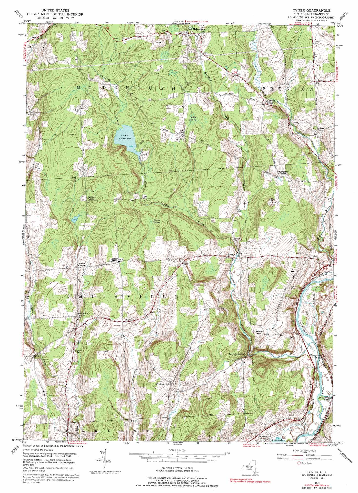
USGS Topo Quad 42075d6 - 1:24,000 scale
| Topo Map Name: | Tyner |
| USGS Topo Quad ID: | 42075d6 |
| Print Size: | ca. 21 1/4" wide x 27" high |
| Southeast Coordinates: | 42.375° N latitude / 75.625° W longitude |
| Map Center Coordinates: | 42.4375° N latitude / 75.6875° W longitude |
| U.S. State: | NY |
| Filename: | o42075d6.jpg |
| Download Map JPG Image: | Tyner topo map 1:24,000 scale |
| Map Type: | Topographic |
| Topo Series: | 7.5´ |
| Map Scale: | 1:24,000 |
| Source of Map Images: | United States Geological Survey (USGS) |
| Alternate Map Versions: |
Tyner NY 1949, updated 1963 Download PDF Buy paper map Tyner NY 1949, updated 1972 Download PDF Buy paper map Tyner NY 1949, updated 1992 Download PDF Buy paper map Tyner NY 1951 Download PDF Buy paper map Tyner NY 2010 Download PDF Buy paper map Tyner NY 2013 Download PDF Buy paper map Tyner NY 2016 Download PDF Buy paper map |
1:24,000 Topo Quads surrounding Tyner
Cuyler |
South Otselic |
Otselic |
Earlville |
Sherburne |
Cincinnatus |
Pitcher |
East Pharsalia |
Norwich |
Holmesville |
Willet |
Smithville Flats |
Tyner |
Oxford |
Guilford |
Whitney Point |
Greene |
Brisben |
West Bainbridge |
Sidney |
Castle Creek |
Chenango Forks |
Belden |
Afton |
North Sanford |
> Back to 42075a1 at 1:100,000 scale
> Back to 42074a1 at 1:250,000 scale
> Back to U.S. Topo Maps home
Tyner topo map: Gazetteer
Tyner: Lakes
Lake Ludlow elevation 444m 1456′Tyner: Populated Places
Adams Corner elevation 419m 1374′Buckley Hollow elevation 347m 1138′
Corbin Corner elevation 456m 1496′
Dibble Corner elevation 478m 1568′
East McDonough elevation 465m 1525′
Smithville Center elevation 419m 1374′
Tyner elevation 378m 1240′
Tyner: Streams
Bear Brook elevation 286m 938′Bowman Creek elevation 289m 948′
Eddy Brook elevation 288m 944′
Edgerton Brook elevation 349m 1145′
Kedron Brook elevation 349m 1145′
Ludlow Creek elevation 374m 1227′
Tyner: Summits
Miller Hill elevation 495m 1624′Painter Hill elevation 400m 1312′
Tyner: Swamps
Corbin Swamp elevation 474m 1555′Spruce Swamp elevation 447m 1466′
Tyner digital topo map on disk
Buy this Tyner topo map showing relief, roads, GPS coordinates and other geographical features, as a high-resolution digital map file on DVD:
New York, Vermont, Connecticut & Western Massachusetts
Buy digital topo maps: New York, Vermont, Connecticut & Western Massachusetts