Norwich Topo Map New York
To zoom in, hover over the map of Norwich
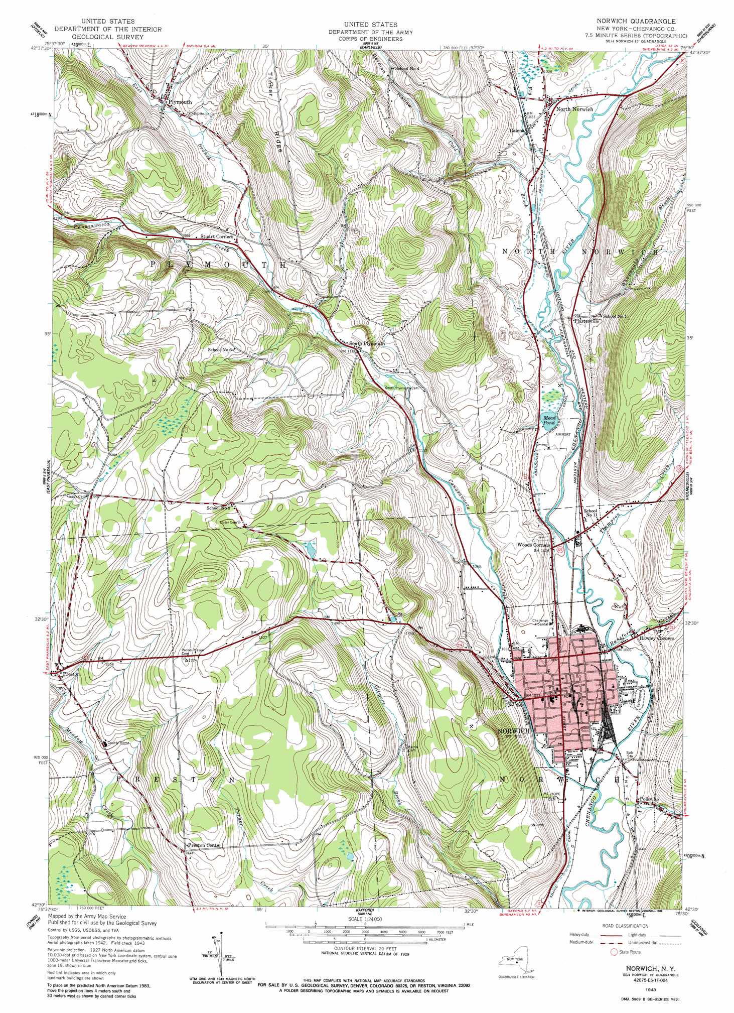
USGS Topo Quad 42075e5 - 1:24,000 scale
| Topo Map Name: | Norwich |
| USGS Topo Quad ID: | 42075e5 |
| Print Size: | ca. 21 1/4" wide x 27" high |
| Southeast Coordinates: | 42.5° N latitude / 75.5° W longitude |
| Map Center Coordinates: | 42.5625° N latitude / 75.5625° W longitude |
| U.S. State: | NY |
| Filename: | o42075e5.jpg |
| Download Map JPG Image: | Norwich topo map 1:24,000 scale |
| Map Type: | Topographic |
| Topo Series: | 7.5´ |
| Map Scale: | 1:24,000 |
| Source of Map Images: | United States Geological Survey (USGS) |
| Alternate Map Versions: |
Norwich NY 1943, updated 1960 Download PDF Buy paper map Norwich NY 1943, updated 1988 Download PDF Buy paper map Norwich NY 1944, updated 1957 Download PDF Buy paper map Norwich NY 2010 Download PDF Buy paper map Norwich NY 2013 Download PDF Buy paper map Norwich NY 2016 Download PDF Buy paper map |
1:24,000 Topo Quads surrounding Norwich
Erieville |
West Eaton |
Hamilton |
Hubbardsville |
Brookfield |
South Otselic |
Otselic |
Earlville |
Sherburne |
New Berlin North |
Pitcher |
East Pharsalia |
Norwich |
Holmesville |
New Berlin South |
Smithville Flats |
Tyner |
Oxford |
Guilford |
Gilbertsville |
Greene |
Brisben |
West Bainbridge |
Sidney |
Unadilla |
> Back to 42075e1 at 1:100,000 scale
> Back to 42074a1 at 1:250,000 scale
> Back to U.S. Topo Maps home
Norwich topo map: Gazetteer
Norwich: Airports
Lieutenant Warren Eaton Airport elevation 307m 1007′Norwich: Lakes
Mead Pond elevation 310m 1017′Norwich: Parks
East Park elevation 309m 1013′Peacock Park elevation 307m 1007′
West Park elevation 309m 1013′
Norwich: Populated Places
Galena elevation 311m 1020′Hawley Corners elevation 313m 1026′
Maple Grove East elevation 299m 980′
North Norwich elevation 316m 1036′
Norwich elevation 309m 1013′
Plasterville elevation 319m 1046′
Plymouth elevation 379m 1243′
Polkville elevation 317m 1040′
Preston elevation 448m 1469′
Preston Center elevation 470m 1541′
South Plymouth elevation 347m 1138′
Valley View Mobile Home Park elevation 342m 1122′
Norwich: Ridges
Tinker Ridge elevation 531m 1742′Norwich: Streams
Canasawacta Creek elevation 299m 980′Cold Brook elevation 305m 1000′
East Branch Canasawacta Creek elevation 360m 1181′
Fly Creek elevation 305m 1000′
Johnson Creek elevation 298m 977′
Ransford Creek elevation 302m 990′
Thompson Creek elevation 299m 980′
Whapanaka Brook elevation 307m 1007′
Norwich: Valleys
German Hollow elevation 316m 1036′Norwich digital topo map on disk
Buy this Norwich topo map showing relief, roads, GPS coordinates and other geographical features, as a high-resolution digital map file on DVD:
New York, Vermont, Connecticut & Western Massachusetts
Buy digital topo maps: New York, Vermont, Connecticut & Western Massachusetts