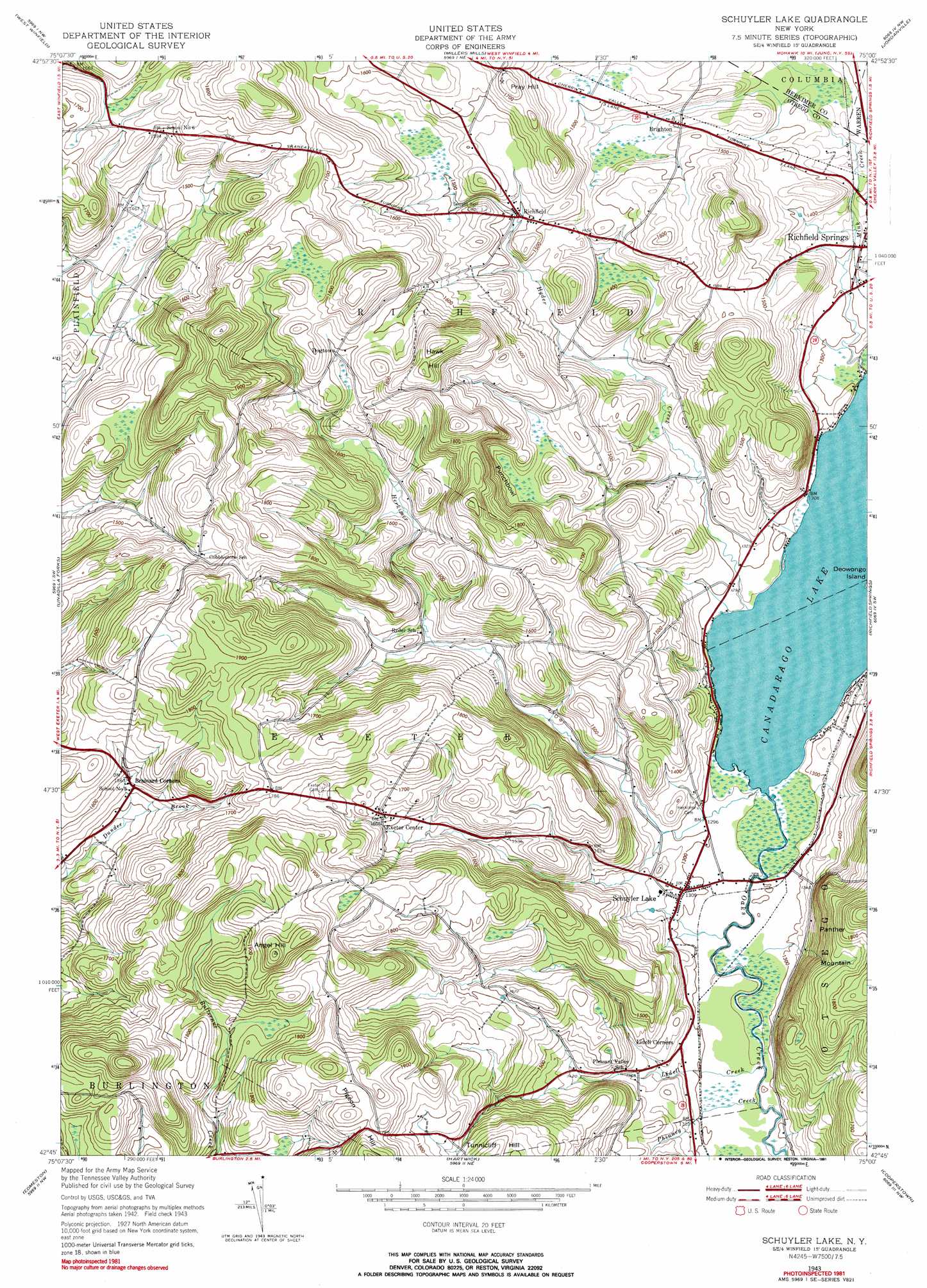
Schuyler Lake Topo Map New York
To zoom in, hover over the map of Schuyler Lake
USGS Topo Quad 42075g1 - 1:24,000 scale
| Topo Map Name: | Schuyler Lake |
| USGS Topo Quad ID: | 42075g1 |
| Print Size: | ca. 21 1/4" wide x 27" high |
| Southeast Coordinates: | 42.75° N latitude / 75° W longitude |
| Map Center Coordinates: | 42.8125° N latitude / 75.0625° W longitude |
| U.S. State: | NY |
| Filename: | o42075g1.jpg |
| Download Map JPG Image: | Schuyler Lake topo map 1:24,000 scale |
| Map Type: | Topographic |
| Topo Series: | 7.5´ |
| Map Scale: | 1:24,000 |
| Source of Map Images: | United States Geological Survey (USGS) |
| Alternate Map Versions: |
Schuyler Lake NY 1943, updated 1953 Download PDF Buy paper map Schuyler Lake NY 1943, updated 1970 Download PDF Buy paper map Schuyler Lake NY 1943, updated 1981 Download PDF Buy paper map Schuyler Lake NY 2010 Download PDF Buy paper map Schuyler Lake NY 2013 Download PDF Buy paper map Schuyler Lake NY 2016 Download PDF Buy paper map |
1:24,000 Topo Quads surrounding Schuyler Lake
Utica West |
Utica East |
Ilion |
Herkimer |
Little Falls |
Cassville |
West Winfield |
Millers Mills |
Jordanville |
Van Hornesville |
Brookfield |
Unadilla Forks |
Schuyler Lake |
Richfield Springs |
East Springfield |
New Berlin North |
Edmeston |
Hartwick |
Cooperstown |
Westford |
New Berlin South |
Morris |
Mount Vision |
Milford |
Schenevus |
> Back to 42075e1 at 1:100,000 scale
> Back to 42074a1 at 1:250,000 scale
> Back to U.S. Topo Maps home
Schuyler Lake topo map: Gazetteer
Schuyler Lake: Cliffs
Punchbowl elevation 505m 1656′Schuyler Lake: Lakes
Canadarago Lake elevation 385m 1263′Schuyler Lake: Populated Places
Brighton elevation 446m 1463′Dogtown elevation 511m 1676′
Exeter Corner elevation 502m 1646′
Lidell Corners elevation 402m 1318′
Richfield elevation 450m 1476′
Schuyler Lake elevation 399m 1309′
Schuyler Lake: Streams
Herkimer Creek elevation 387m 1269′Hyder Creek elevation 385m 1263′
Lidell Creek elevation 386m 1266′
Mink Creek elevation 388m 1272′
Phinney Creek elevation 386m 1266′
Schuyler Lake: Summits
Angel Hill elevation 636m 2086′Hawk Hill elevation 593m 1945′
Pray Hill elevation 530m 1738′
Schuyler Lake digital topo map on disk
Buy this Schuyler Lake topo map showing relief, roads, GPS coordinates and other geographical features, as a high-resolution digital map file on DVD:
New York, Vermont, Connecticut & Western Massachusetts
Buy digital topo maps: New York, Vermont, Connecticut & Western Massachusetts