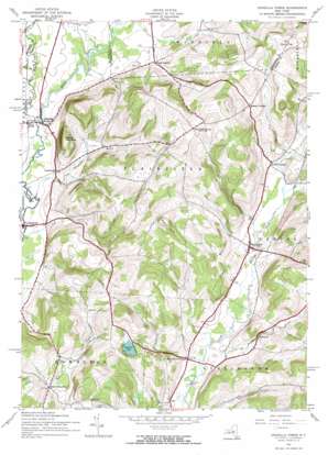
Unadilla Forks Topo Map New York
To zoom in, hover over the map of Unadilla Forks
USGS Topo Quad 42075g2 - 1:24,000 scale
| Topo Map Name: | Unadilla Forks |
| USGS Topo Quad ID: | 42075g2 |
| Print Size: | ca. 21 1/4" wide x 27" high |
| Southeast Coordinates: | 42.75° N latitude / 75.125° W longitude |
| Map Center Coordinates: | 42.8125° N latitude / 75.1875° W longitude |
| U.S. State: | NY |
| Filename: | o42075g2.jpg |
| Download Map JPG Image: | Unadilla Forks topo map 1:24,000 scale |
| Map Type: | Topographic |
| Topo Series: | 7.5´ |
| Map Scale: | 1:24,000 |
| Source of Map Images: | United States Geological Survey (USGS) |
| Alternate Map Versions: |
Unadilla Forks NY 1943, updated 1960 Download PDF Buy paper map Unadilla Forks NY 1943, updated 1971 Download PDF Buy paper map Unadilla Forks NY 2010 Download PDF Buy paper map Unadilla Forks NY 2013 Download PDF Buy paper map Unadilla Forks NY 2016 Download PDF Buy paper map |
1:24,000 Topo Quads surrounding Unadilla Forks
> Back to 42075e1 at 1:100,000 scale
> Back to 42074a1 at 1:250,000 scale
> Back to U.S. Topo Maps home
Unadilla Forks topo map: Gazetteer
Unadilla Forks: Airports
TGP-245 Heliport elevation 386m 1266′Unadilla Forks: Lakes
Summit Lake elevation 503m 1650′Unadilla Forks: Populated Places
Huntly Corners elevation 409m 1341′Lloydsville elevation 370m 1213′
North Edmeston elevation 449m 1473′
Pecktown elevation 418m 1371′
Plainfield Center elevation 532m 1745′
Unadilla Forks elevation 358m 1174′
West Exeter elevation 400m 1312′
Woods Corners elevation 376m 1233′
Unadilla Forks: Streams
Campbell Brook elevation 343m 1125′Dundee Brook elevation 384m 1259′
West Branch Unadilla River elevation 348m 1141′
Unadilla Forks: Summits
Mount Markham elevation 514m 1686′Noahs Rump elevation 607m 1991′
Round Top elevation 575m 1886′
Welch Hill elevation 470m 1541′
Unadilla Forks digital topo map on disk
Buy this Unadilla Forks topo map showing relief, roads, GPS coordinates and other geographical features, as a high-resolution digital map file on DVD:
New York, Vermont, Connecticut & Western Massachusetts
Buy digital topo maps: New York, Vermont, Connecticut & Western Massachusetts


