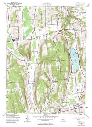
De Ruyter Topo Map New York
To zoom in, hover over the map of De Ruyter
USGS Topo Quad 42075g8 - 1:24,000 scale
| Topo Map Name: | De Ruyter |
| USGS Topo Quad ID: | 42075g8 |
| Print Size: | ca. 21 1/4" wide x 27" high |
| Southeast Coordinates: | 42.75° N latitude / 75.875° W longitude |
| Map Center Coordinates: | 42.8125° N latitude / 75.9375° W longitude |
| U.S. State: | NY |
| Filename: | o42075g8.jpg |
| Download Map JPG Image: | De Ruyter topo map 1:24,000 scale |
| Map Type: | Topographic |
| Topo Series: | 7.5´ |
| Map Scale: | 1:24,000 |
| Source of Map Images: | United States Geological Survey (USGS) |
| Alternate Map Versions: |
De Ruyter NY 1943, updated 1958 Download PDF Buy paper map De Ruyter NY 1943, updated 1961 Download PDF Buy paper map De Ruyter NY 1943, updated 1961 Download PDF Buy paper map Deruyter NY 1943, updated 1990 Download PDF Buy paper map DeRuyter NY 2010 Download PDF Buy paper map DeRuyter NY 2013 Download PDF Buy paper map DeRuyter NY 2016 Download PDF Buy paper map |
1:24,000 Topo Quads surrounding De Ruyter
> Back to 42075e1 at 1:100,000 scale
> Back to 42074a1 at 1:250,000 scale
> Back to U.S. Topo Maps home
De Ruyter topo map: Gazetteer
De Ruyter: Falls
Delphi Falls elevation 303m 994′De Ruyter: Lakes
Carpenter Pond elevation 387m 1269′De Ruyter: Populated Places
Cowles Settlement elevation 440m 1443′DeRuyter elevation 392m 1286′
Fabius elevation 386m 1266′
Keeney elevation 373m 1223′
Puckerville elevation 398m 1305′
Union elevation 383m 1256′
West Woodstock elevation 435m 1427′
De Ruyter: Reservoirs
DeRuyter Reservoir elevation 391m 1282′De Ruyter: Streams
Carpenter Creek elevation 383m 1256′East Branch Limestone Creek elevation 291m 954′
East Branch Tioughnioga Creek elevation 383m 1256′
Fabius Brook elevation 369m 1210′
Hills Creek elevation 368m 1207′
Middle Branch Tioughnioga Creek elevation 383m 1256′
The Old Fly elevation 378m 1240′
De Ruyter: Summits
Arab Hill elevation 593m 1945′Hogsback elevation 551m 1807′
Morgan Hill elevation 618m 2027′
Stockham Hill elevation 503m 1650′
De Ruyter: Valleys
The Gulf elevation 299m 980′De Ruyter digital topo map on disk
Buy this De Ruyter topo map showing relief, roads, GPS coordinates and other geographical features, as a high-resolution digital map file on DVD:
New York, Vermont, Connecticut & Western Massachusetts
Buy digital topo maps: New York, Vermont, Connecticut & Western Massachusetts


