West Winfield Topo Map New York
To zoom in, hover over the map of West Winfield
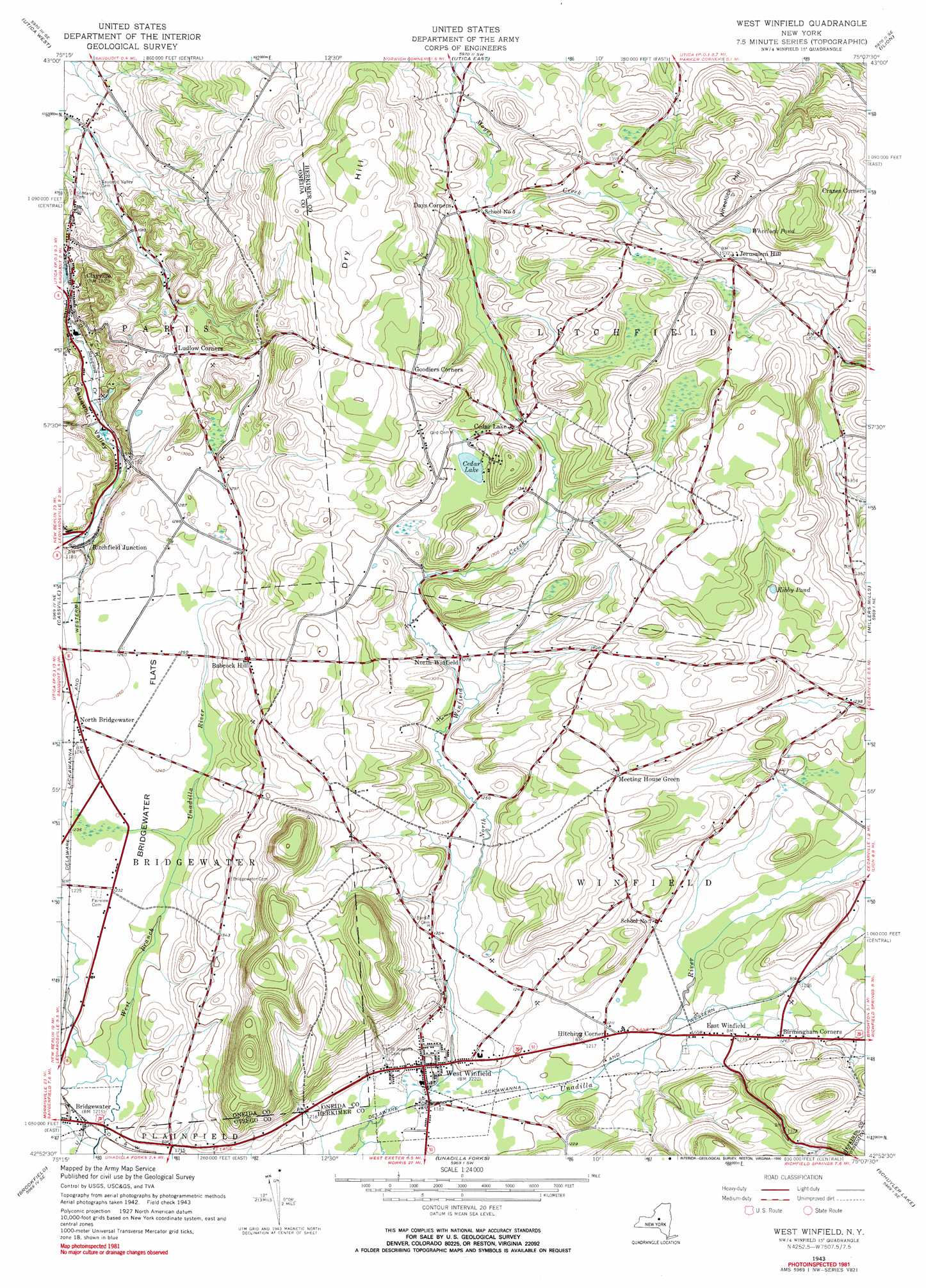
USGS Topo Quad 42075h2 - 1:24,000 scale
| Topo Map Name: | West Winfield |
| USGS Topo Quad ID: | 42075h2 |
| Print Size: | ca. 21 1/4" wide x 27" high |
| Southeast Coordinates: | 42.875° N latitude / 75.125° W longitude |
| Map Center Coordinates: | 42.9375° N latitude / 75.1875° W longitude |
| U.S. State: | NY |
| Filename: | o42075h2.jpg |
| Download Map JPG Image: | West Winfield topo map 1:24,000 scale |
| Map Type: | Topographic |
| Topo Series: | 7.5´ |
| Map Scale: | 1:24,000 |
| Source of Map Images: | United States Geological Survey (USGS) |
| Alternate Map Versions: |
West Winfield NY 1943, updated 1960 Download PDF Buy paper map West Winfield NY 1943, updated 1969 Download PDF Buy paper map West Winfield NY 1943, updated 1990 Download PDF Buy paper map West Winfield NY 2010 Download PDF Buy paper map West Winfield NY 2013 Download PDF Buy paper map West Winfield NY 2016 Download PDF Buy paper map |
1:24,000 Topo Quads surrounding West Winfield
Rome |
Oriskany |
South Trenton |
Newport |
Middleville |
Clinton |
Utica West |
Utica East |
Ilion |
Herkimer |
Oriskany Falls |
Cassville |
West Winfield |
Millers Mills |
Jordanville |
Hubbardsville |
Brookfield |
Unadilla Forks |
Schuyler Lake |
Richfield Springs |
Sherburne |
New Berlin North |
Edmeston |
Hartwick |
Cooperstown |
> Back to 42075e1 at 1:100,000 scale
> Back to 42074a1 at 1:250,000 scale
> Back to U.S. Topo Maps home
West Winfield topo map: Gazetteer
West Winfield: Airports
Oertle Field elevation 374m 1227′West Winfield: Flats
Bridgewater Flats elevation 380m 1246′West Winfield: Lakes
Cedar Lake elevation 417m 1368′Kibby Pond elevation 427m 1400′
Wheelock Pond elevation 455m 1492′
West Winfield: Populated Places
Babcock Hill elevation 416m 1364′Birmingham Corners elevation 386m 1266′
Cedar Lake elevation 406m 1332′
Days Corners elevation 409m 1341′
East Winfield elevation 377m 1236′
Hitching Corner elevation 369m 1210′
Jersalem Hill elevation 459m 1505′
North Bridgewater elevation 383m 1256′
North Winfield elevation 389m 1276′
Pine Village Estates elevation 385m 1263′
Ritchfield Junction elevation 354m 1161′
West Winfield elevation 363m 1190′
West Winfield: Streams
North Winfield Creek elevation 361m 1184′West Winfield: Summits
Dry Hill elevation 500m 1640′Wheelock Hill elevation 500m 1640′
West Winfield: Valleys
Sauquoit Valley elevation 270m 885′West Winfield digital topo map on disk
Buy this West Winfield topo map showing relief, roads, GPS coordinates and other geographical features, as a high-resolution digital map file on DVD:
New York, Vermont, Connecticut & Western Massachusetts
Buy digital topo maps: New York, Vermont, Connecticut & Western Massachusetts