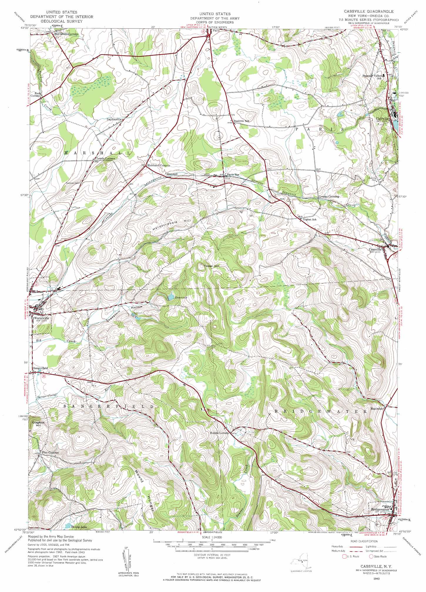
Cassville Topo Map New York
To zoom in, hover over the map of Cassville
USGS Topo Quad 42075h3 - 1:24,000 scale
| Topo Map Name: | Cassville |
| USGS Topo Quad ID: | 42075h3 |
| Print Size: | ca. 21 1/4" wide x 27" high |
| Southeast Coordinates: | 42.875° N latitude / 75.25° W longitude |
| Map Center Coordinates: | 42.9375° N latitude / 75.3125° W longitude |
| U.S. State: | NY |
| Filename: | o42075h3.jpg |
| Download Map JPG Image: | Cassville topo map 1:24,000 scale |
| Map Type: | Topographic |
| Topo Series: | 7.5´ |
| Map Scale: | 1:24,000 |
| Source of Map Images: | United States Geological Survey (USGS) |
| Alternate Map Versions: |
Cassville NY 1943, updated 1960 Download PDF Buy paper map Cassville NY 1943, updated 1960 Download PDF Buy paper map Cassville NY 2010 Download PDF Buy paper map Cassville NY 2013 Download PDF Buy paper map Cassville NY 2016 Download PDF Buy paper map |
1:24,000 Topo Quads surrounding Cassville
Verona |
Rome |
Oriskany |
South Trenton |
Newport |
Vernon |
Clinton |
Utica West |
Utica East |
Ilion |
Munnsville |
Oriskany Falls |
Cassville |
West Winfield |
Millers Mills |
Hamilton |
Hubbardsville |
Brookfield |
Unadilla Forks |
Schuyler Lake |
Earlville |
Sherburne |
New Berlin North |
Edmeston |
Hartwick |
> Back to 42075e1 at 1:100,000 scale
> Back to 42074a1 at 1:250,000 scale
> Back to U.S. Topo Maps home
Cassville topo map: Gazetteer
Cassville: Lakes
Bailey Lake elevation 475m 1558′Cassville: Populated Places
Bridgewater elevation 369m 1210′Cassville elevation 378m 1240′
Clayville elevation 293m 961′
Daytonville elevation 416m 1364′
Fitchs Mobile Home Park elevation 382m 1253′
Five Corners elevation 430m 1410′
Greens Crossing elevation 408m 1338′
Hobin Corners elevation 449m 1473′
Mapledale elevation 383m 1256′
Marshall elevation 416m 1364′
Paris Station elevation 432m 1417′
Cassville: Summits
Cragfoot Hill elevation 482m 1581′Hardscrabble Hill elevation 546m 1791′
Mount Hunger elevation 588m 1929′
Tassel Hill elevation 592m 1942′
Cassville: Valleys
Sheepskin Hollow elevation 382m 1253′Cassville digital topo map on disk
Buy this Cassville topo map showing relief, roads, GPS coordinates and other geographical features, as a high-resolution digital map file on DVD:
New York, Vermont, Connecticut & Western Massachusetts
Buy digital topo maps: New York, Vermont, Connecticut & Western Massachusetts