Ithaca West Topo Map New York
To zoom in, hover over the map of Ithaca West
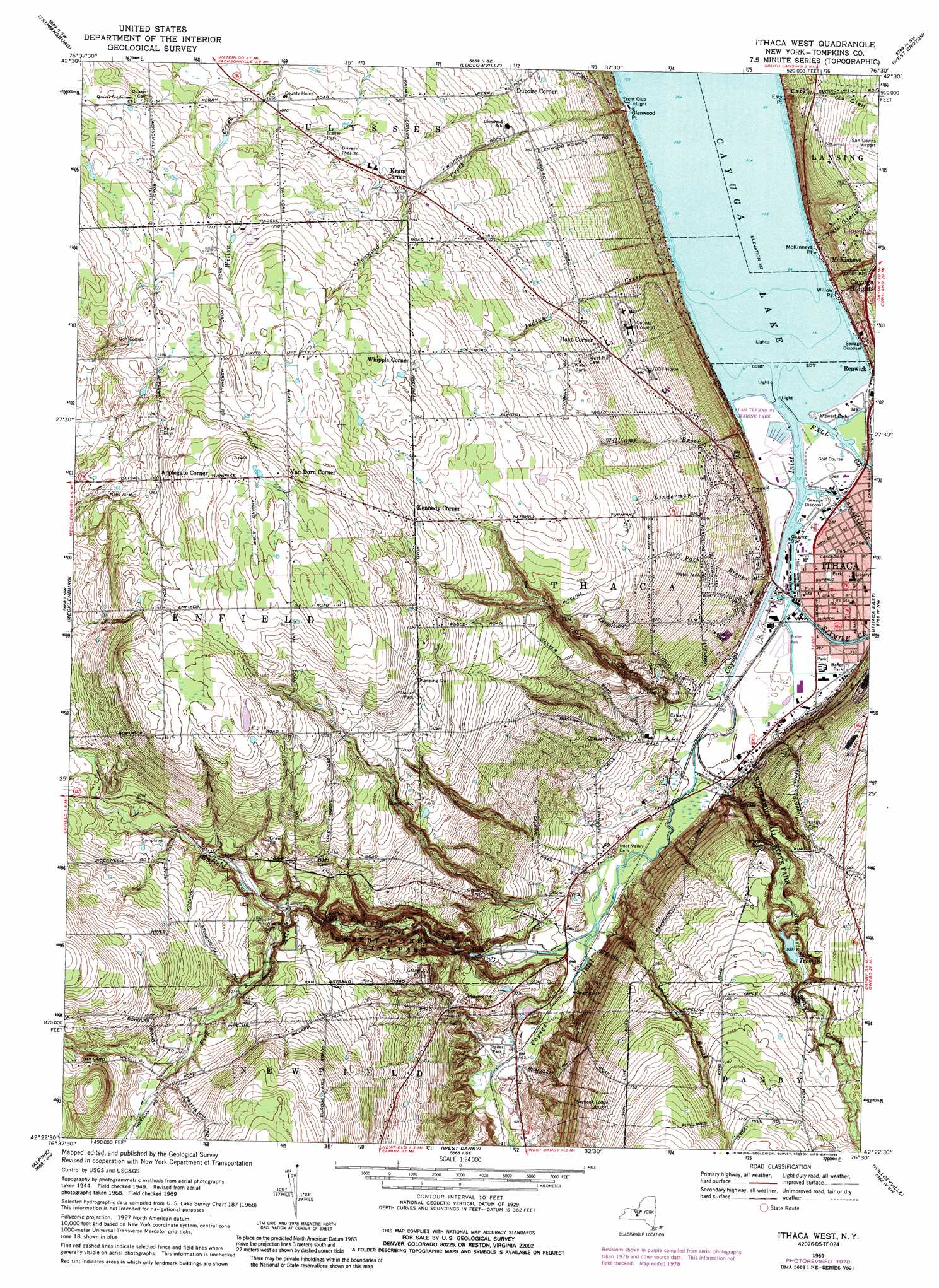
USGS Topo Quad 42076d5 - 1:24,000 scale
| Topo Map Name: | Ithaca West |
| USGS Topo Quad ID: | 42076d5 |
| Print Size: | ca. 21 1/4" wide x 27" high |
| Southeast Coordinates: | 42.375° N latitude / 76.5° W longitude |
| Map Center Coordinates: | 42.4375° N latitude / 76.5625° W longitude |
| U.S. State: | NY |
| Filename: | o42076d5.jpg |
| Download Map JPG Image: | Ithaca West topo map 1:24,000 scale |
| Map Type: | Topographic |
| Topo Series: | 7.5´ |
| Map Scale: | 1:24,000 |
| Source of Map Images: | United States Geological Survey (USGS) |
| Alternate Map Versions: |
Ithaca West NY 1949, updated 1952 Download PDF Buy paper map Ithaca West NY 1949, updated 1952 Download PDF Buy paper map Ithaca West NY 1949, updated 1963 Download PDF Buy paper map Ithaca West NY 1949, updated 1967 Download PDF Buy paper map Ithaca West NY 1949, updated 1967 Download PDF Buy paper map Ithaca West NY 1969, updated 1971 Download PDF Buy paper map Ithaca West NY 1969, updated 1989 Download PDF Buy paper map Ithaca West NY 1978, updated 1979 Download PDF Buy paper map Ithaca West NY 2010 Download PDF Buy paper map Ithaca West NY 2013 Download PDF Buy paper map Ithaca West NY 2016 Download PDF Buy paper map |
1:24,000 Topo Quads surrounding Ithaca West
Ovid |
Sheldrake |
Genoa |
Moravia |
Sempronius |
Lodi |
Trumansburg |
Ludlowville |
West Groton |
Groton |
Burdett |
Mecklenburg |
Ithaca West |
Ithaca East |
Dryden |
Montour Falls |
Alpine |
West Danby |
Willseyville |
Speedsville |
Horseheads |
Erin |
Van Etten |
Spencer |
Candor |
> Back to 42076a1 at 1:100,000 scale
> Back to 42076a1 at 1:250,000 scale
> Back to U.S. Topo Maps home
Ithaca West topo map: Gazetteer
Ithaca West: Airports
Grund Field elevation 442m 1450′James Henion Private Field elevation 404m 1325′
Neno International Airport elevation 376m 1233′
Skyhook Lodge Airport elevation 346m 1135′
Ithaca West: Capes
Esty Point elevation 117m 383′Glenwood Point elevation 117m 383′
McKinneys Point elevation 117m 383′
Willow Point elevation 117m 383′
Ithaca West: Cliffs
Pinnacle Rock elevation 272m 892′Ithaca West: Falls
Lucifer Falls elevation 233m 764′Ithaca West: Harbors
Oldport Harbour elevation 117m 383′Ithaca West: Lakes
Lake Treman elevation 292m 958′Ithaca West: Parks
Alan Treman State Marine Park elevation 117m 383′Baker Park elevation 118m 387′
Buttermilk Falls State Park elevation 291m 954′
Conway Park elevation 119m 390′
Freeman Field elevation 282m 925′
Jim Butterfield Stadium elevation 292m 958′
Robert H Treman State park elevation 217m 711′
Saint John Park elevation 119m 390′
Stewart Park elevation 117m 383′
Washington Park elevation 119m 390′
Ithaca West: Populated Places
Applegate Corner elevation 395m 1295′College View Trailer Park elevation 144m 472′
Duboise Corner elevation 256m 839′
Hayt Corner elevation 279m 915′
Kennedy Corner elevation 386m 1266′
Krum Corner elevation 328m 1076′
McKinneys elevation 124m 406′
Meadowbrook Park elevation 154m 505′
Van Dorn Corner elevation 431m 1414′
Whipple Corner elevation 371m 1217′
Ithaca West: Streams
Buttermilk Creek elevation 121m 396′Cascadilla Creek elevation 117m 383′
Cayuga Inlet elevation 116m 380′
Cliff Park Brook elevation 117m 383′
Enfield Creek elevation 326m 1069′
Fall Creek elevation 116m 380′
Fish Kill elevation 270m 885′
Glenwood Creek elevation 117m 383′
Indian Creek elevation 116m 380′
Lick Brook elevation 131m 429′
Linderman Creek elevation 117m 383′
Renwick Brook elevation 117m 383′
Sixmile Creek elevation 117m 383′
West Branch Cayuga Inlet elevation 149m 488′
Williams Brook elevation 116m 380′
Ithaca West: Valleys
Coy Glen elevation 122m 400′Enfield Glen elevation 133m 436′
Esty Glen elevation 117m 383′
Twin Glens elevation 121m 396′
Ithaca West digital topo map on disk
Buy this Ithaca West topo map showing relief, roads, GPS coordinates and other geographical features, as a high-resolution digital map file on DVD:
New York, Vermont, Connecticut & Western Massachusetts
Buy digital topo maps: New York, Vermont, Connecticut & Western Massachusetts