Sempronius Topo Map New York
To zoom in, hover over the map of Sempronius
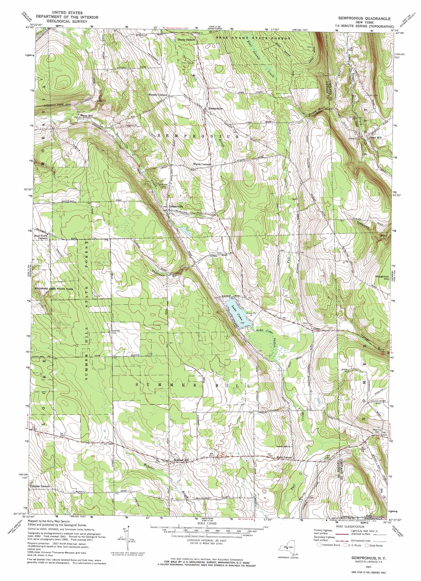
USGS Topo Quad 42076f3 - 1:24,000 scale
| Topo Map Name: | Sempronius |
| USGS Topo Quad ID: | 42076f3 |
| Print Size: | ca. 21 1/4" wide x 27" high |
| Southeast Coordinates: | 42.625° N latitude / 76.25° W longitude |
| Map Center Coordinates: | 42.6875° N latitude / 76.3125° W longitude |
| U.S. State: | NY |
| Filename: | o42076f3.jpg |
| Download Map JPG Image: | Sempronius topo map 1:24,000 scale |
| Map Type: | Topographic |
| Topo Series: | 7.5´ |
| Map Scale: | 1:24,000 |
| Source of Map Images: | United States Geological Survey (USGS) |
| Alternate Map Versions: |
Sempronius NY 1943, updated 1953 Download PDF Buy paper map Sempronius NY 1971, updated 1974 Download PDF Buy paper map Sempronius NY 2010 Download PDF Buy paper map Sempronius NY 2013 Download PDF Buy paper map Sempronius NY 2016 Download PDF Buy paper map |
1:24,000 Topo Quads surrounding Sempronius
Auburn |
Skaneateles |
Marcellus |
South Onondaga |
Jamesville |
Scipio Center |
Owasco |
Spafford |
Otisco Valley |
Tully |
Genoa |
Moravia |
Sempronius |
Homer |
Truxton |
Ludlowville |
West Groton |
Groton |
Cortland |
Mcgraw |
Ithaca West |
Ithaca East |
Dryden |
Harford |
Marathon |
> Back to 42076e1 at 1:100,000 scale
> Back to 42076a1 at 1:250,000 scale
> Back to U.S. Topo Maps home
Sempronius topo map: Gazetteer
Sempronius: Forests
Bear Swamp State Forest elevation 516m 1692′Summer Hill State Forest elevation 474m 1555′
Sempronius: Lakes
Lake Como elevation 399m 1309′Sempronius: Populated Places
Como elevation 411m 1348′Dresserville elevation 392m 1286′
Grout Mill elevation 368m 1207′
Halls Corner elevation 416m 1364′
Morse Mill elevation 329m 1079′
Sempronius elevation 487m 1597′
Summer Hill elevation 464m 1522′
Sempronius: Streams
Lake Como Outlet elevation 398m 1305′Mill Brook elevation 395m 1295′
Sempronius: Valleys
Scott Gulf elevation 386m 1266′Sherman Gulf elevation 426m 1397′
Sempronius digital topo map on disk
Buy this Sempronius topo map showing relief, roads, GPS coordinates and other geographical features, as a high-resolution digital map file on DVD:
New York, Vermont, Connecticut & Western Massachusetts
Buy digital topo maps: New York, Vermont, Connecticut & Western Massachusetts