Moravia Topo Map New York
To zoom in, hover over the map of Moravia
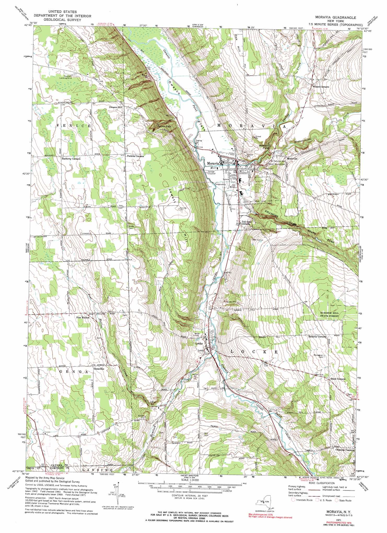
USGS Topo Quad 42076f4 - 1:24,000 scale
| Topo Map Name: | Moravia |
| USGS Topo Quad ID: | 42076f4 |
| Print Size: | ca. 21 1/4" wide x 27" high |
| Southeast Coordinates: | 42.625° N latitude / 76.375° W longitude |
| Map Center Coordinates: | 42.6875° N latitude / 76.4375° W longitude |
| U.S. State: | NY |
| Filename: | o42076f4.jpg |
| Download Map JPG Image: | Moravia topo map 1:24,000 scale |
| Map Type: | Topographic |
| Topo Series: | 7.5´ |
| Map Scale: | 1:24,000 |
| Source of Map Images: | United States Geological Survey (USGS) |
| Alternate Map Versions: |
Moravia NY 1943, updated 1958 Download PDF Buy paper map Moravia NY 1943, updated 1961 Download PDF Buy paper map Moravia NY 1971, updated 1974 Download PDF Buy paper map Moravia NY 1971, updated 1990 Download PDF Buy paper map Moravia NY 2011 Download PDF Buy paper map Moravia NY 2013 Download PDF Buy paper map Moravia NY 2016 Download PDF Buy paper map |
1:24,000 Topo Quads surrounding Moravia
Cayuga |
Auburn |
Skaneateles |
Marcellus |
South Onondaga |
Union Springs |
Scipio Center |
Owasco |
Spafford |
Otisco Valley |
Sheldrake |
Genoa |
Moravia |
Sempronius |
Homer |
Trumansburg |
Ludlowville |
West Groton |
Groton |
Cortland |
Mecklenburg |
Ithaca West |
Ithaca East |
Dryden |
Harford |
> Back to 42076e1 at 1:100,000 scale
> Back to 42076a1 at 1:250,000 scale
> Back to U.S. Topo Maps home
Moravia topo map: Gazetteer
Moravia: Airports
Vans Airport elevation 225m 738′Moravia: Falls
Montville Falls elevation 235m 770′Parson Falls elevation 300m 984′
Moravia: Flats
Owasco Flats elevation 221m 725′Moravia: Parks
Fillmore Glen State Park elevation 324m 1062′Moravia: Populated Places
Chipman Corners elevation 391m 1282′Goosetree elevation 381m 1250′
Locke elevation 241m 790′
Montville elevation 304m 997′
Moravia elevation 224m 734′
Owasco Hill elevation 406m 1332′
Pine Hollow elevation 382m 1253′
Toll Gate Corners elevation 231m 757′
Wilson Corners elevation 334m 1095′
Moravia: Streams
Decker Creek elevation 233m 764′Dresserville Creek elevation 234m 767′
Hemlock Creek elevation 238m 780′
Mill Creek elevation 218m 715′
Pine Hollow Creek elevation 268m 879′
Moravia: Summits
Jewett Hill elevation 440m 1443′Moravia digital topo map on disk
Buy this Moravia topo map showing relief, roads, GPS coordinates and other geographical features, as a high-resolution digital map file on DVD:
New York, Vermont, Connecticut & Western Massachusetts
Buy digital topo maps: New York, Vermont, Connecticut & Western Massachusetts