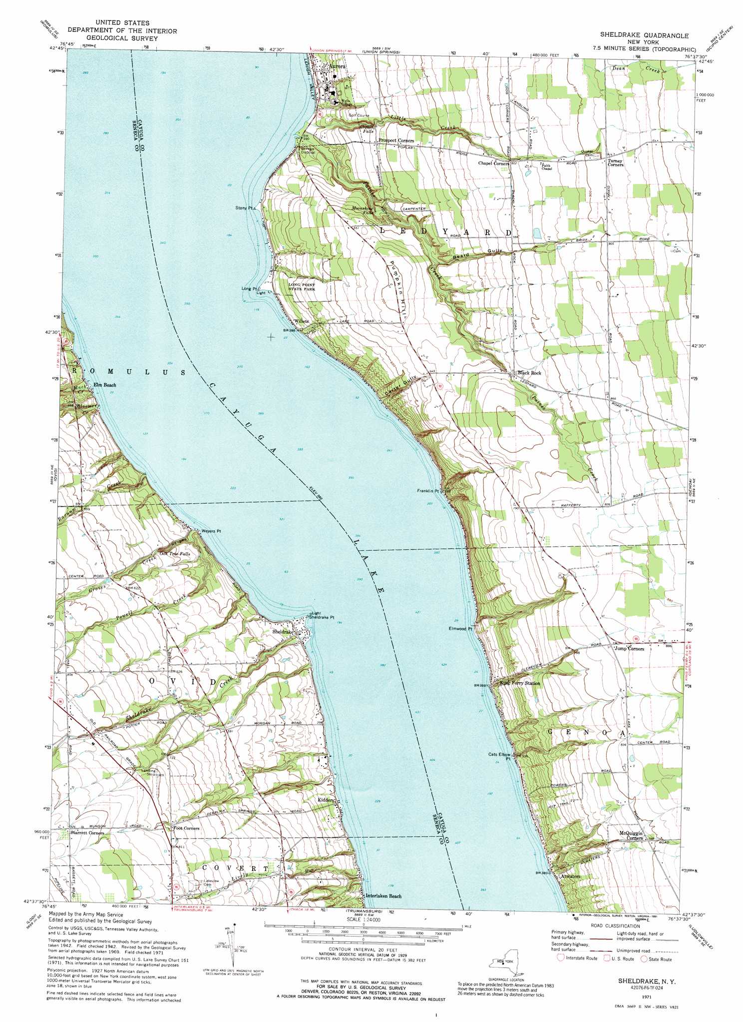
Sheldrake Topo Map New York
To zoom in, hover over the map of Sheldrake
USGS Topo Quad 42076f6 - 1:24,000 scale
| Topo Map Name: | Sheldrake |
| USGS Topo Quad ID: | 42076f6 |
| Print Size: | ca. 21 1/4" wide x 27" high |
| Southeast Coordinates: | 42.625° N latitude / 76.625° W longitude |
| Map Center Coordinates: | 42.6875° N latitude / 76.6875° W longitude |
| U.S. State: | NY |
| Filename: | o42076f6.jpg |
| Download Map JPG Image: | Sheldrake topo map 1:24,000 scale |
| Map Type: | Topographic |
| Topo Series: | 7.5´ |
| Map Scale: | 1:24,000 |
| Source of Map Images: | United States Geological Survey (USGS) |
| Alternate Map Versions: |
Sheldrake NY 1942, updated 1960 Download PDF Buy paper map Sheldrake NY 1971, updated 1974 Download PDF Buy paper map Sheldrake NY 1971, updated 1991 Download PDF Buy paper map Sheldrake NY 2010 Download PDF Buy paper map Sheldrake NY 2013 Download PDF Buy paper map Sheldrake NY 2016 Download PDF Buy paper map |
1:24,000 Topo Quads surrounding Sheldrake
Geneva North |
Seneca Falls |
Cayuga |
Auburn |
Skaneateles |
Geneva South |
Romulus |
Union Springs |
Scipio Center |
Owasco |
Dresden |
Ovid |
Sheldrake |
Genoa |
Moravia |
Dundee |
Lodi |
Trumansburg |
Ludlowville |
West Groton |
Reading Center |
Burdett |
Mecklenburg |
Ithaca West |
Ithaca East |
> Back to 42076e1 at 1:100,000 scale
> Back to 42076a1 at 1:250,000 scale
> Back to U.S. Topo Maps home
Sheldrake topo map: Gazetteer
Sheldrake: Airports
Airy-Acres Airport elevation 247m 810′Match Mate Airport elevation 251m 823′
Sheldrake: Capes
Cats Elbow Point elevation 120m 393′Elmwood Point elevation 117m 383′
Franklin Point elevation 118m 387′
Long Point elevation 117m 383′
Sheldrake Point elevation 117m 383′
Stony Point elevation 116m 380′
Weyers Point elevation 118m 387′
Sheldrake: Falls
Clifton Falls elevation 157m 515′Hosmer Falls elevation 152m 498′
Moonshine Falls elevation 139m 456′
Oak Tree Falls elevation 140m 459′
Sheldrake: Lakes
Cayuga Lake elevation 116m 380′Sheldrake: Parks
Long Point State Park elevation 160m 524′Sheldrake: Populated Places
Atwaters elevation 125m 410′Black Rock elevation 223m 731′
Elm Beach elevation 118m 387′
Interlaken Beach elevation 117m 383′
Kidders elevation 119m 390′
King Ferry Station elevation 120m 393′
Sheldrake elevation 122m 400′
Willets elevation 119m 390′
Sheldrake: Streams
Barnum Creek elevation 116m 380′Bloomer Creek elevation 116m 380′
Buttlers Hollow elevation 118m 387′
Groves Creek elevation 117m 383′
Little Creek elevation 116m 380′
Lively Run elevation 116m 380′
Mack Creek elevation 117m 383′
Paines Creek elevation 116m 380′
Powell Creek elevation 119m 390′
Sheldrake Creek elevation 116m 380′
Sheldrake: Summits
Pumpkin Hill elevation 215m 705′Sheldrake: Valleys
Beard Gully elevation 169m 554′Carter Gully elevation 116m 380′
Sheldrake digital topo map on disk
Buy this Sheldrake topo map showing relief, roads, GPS coordinates and other geographical features, as a high-resolution digital map file on DVD:
New York, Vermont, Connecticut & Western Massachusetts
Buy digital topo maps: New York, Vermont, Connecticut & Western Massachusetts