Tully Topo Map New York
To zoom in, hover over the map of Tully
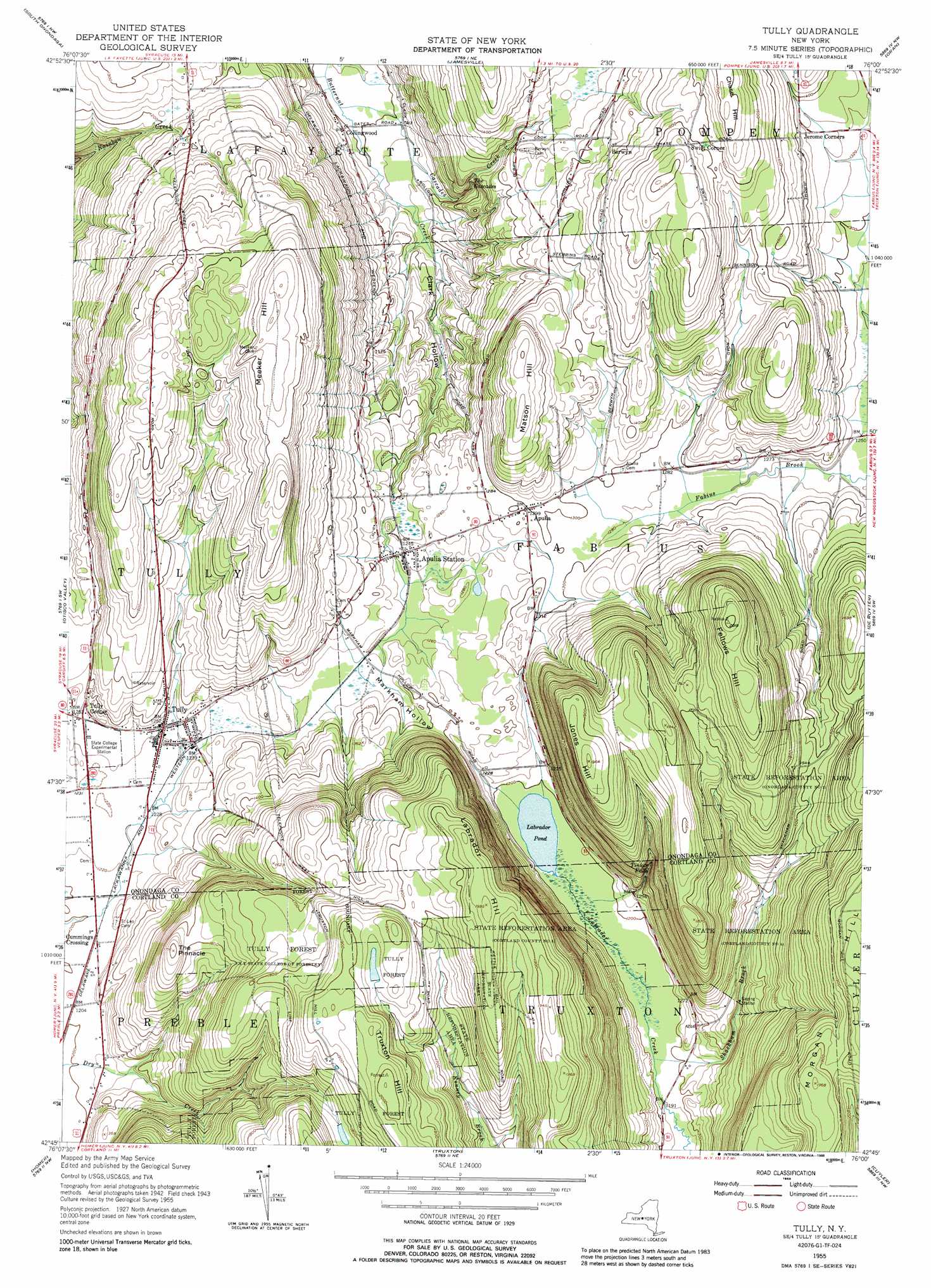
USGS Topo Quad 42076g1 - 1:24,000 scale
| Topo Map Name: | Tully |
| USGS Topo Quad ID: | 42076g1 |
| Print Size: | ca. 21 1/4" wide x 27" high |
| Southeast Coordinates: | 42.75° N latitude / 76° W longitude |
| Map Center Coordinates: | 42.8125° N latitude / 76.0625° W longitude |
| U.S. State: | NY |
| Filename: | o42076g1.jpg |
| Download Map JPG Image: | Tully topo map 1:24,000 scale |
| Map Type: | Topographic |
| Topo Series: | 7.5´ |
| Map Scale: | 1:24,000 |
| Source of Map Images: | United States Geological Survey (USGS) |
| Alternate Map Versions: |
Tully NY 1943, updated 1953 Download PDF Buy paper map Tully NY 1955, updated 1956 Download PDF Buy paper map Tully NY 1955, updated 1963 Download PDF Buy paper map Tully NY 1955, updated 1968 Download PDF Buy paper map Tully NY 1955, updated 1988 Download PDF Buy paper map Tully NY 2010 Download PDF Buy paper map Tully NY 2013 Download PDF Buy paper map Tully NY 2016 Download PDF Buy paper map |
1:24,000 Topo Quads surrounding Tully
Camillus |
Syracuse West |
Syracuse East |
Manlius |
Canastota |
Marcellus |
South Onondaga |
Jamesville |
Oran |
Cazenovia |
Spafford |
Otisco Valley |
Tully |
De Ruyter |
Erieville |
Sempronius |
Homer |
Truxton |
Cuyler |
South Otselic |
Groton |
Cortland |
Mcgraw |
Cincinnatus |
Pitcher |
> Back to 42076e1 at 1:100,000 scale
> Back to 42076a1 at 1:250,000 scale
> Back to U.S. Topo Maps home
Tully topo map: Gazetteer
Tully: Airports
Thermal Ridge Gliderport elevation 365m 1197′Tully: Falls
The Cascades elevation 361m 1184′Tinker Falls elevation 407m 1335′
Tully: Forests
State Reforestation Area elevation 553m 1814′State Reforestation Area elevation 509m 1669′
Tully Forest elevation 527m 1729′
Tully: Lakes
Labrador Pond elevation 363m 1190′Stump Pond (historical) elevation 369m 1210′
Tully: Mines
Palladino Pit elevation 392m 1286′Tully: Populated Places
Apulia elevation 395m 1295′Apulia Station elevation 379m 1243′
Berwyn elevation 440m 1443′
Collingwood elevation 281m 921′
Cummings Crossing elevation 369m 1210′
Swift Corner elevation 499m 1637′
Tully elevation 381m 1250′
Tully Center elevation 382m 1253′
Tully Mobile Home Park elevation 371m 1217′
Tully: Streams
Cascades Creek elevation 272m 892′Shackham Brook elevation 364m 1194′
Tully: Summits
Chase Hill elevation 524m 1719′Fellows Hill elevation 611m 2004′
Jones Hill elevation 598m 1961′
Labrador Hill elevation 606m 1988′
Matson Hill elevation 485m 1591′
Meeker Hill elevation 548m 1797′
The Pinnacle elevation 522m 1712′
Truxton Hill elevation 616m 2020′
Tully: Valleys
Clark Hollow elevation 283m 928′Markham Hollow elevation 378m 1240′
Tully digital topo map on disk
Buy this Tully topo map showing relief, roads, GPS coordinates and other geographical features, as a high-resolution digital map file on DVD:
New York, Vermont, Connecticut & Western Massachusetts
Buy digital topo maps: New York, Vermont, Connecticut & Western Massachusetts