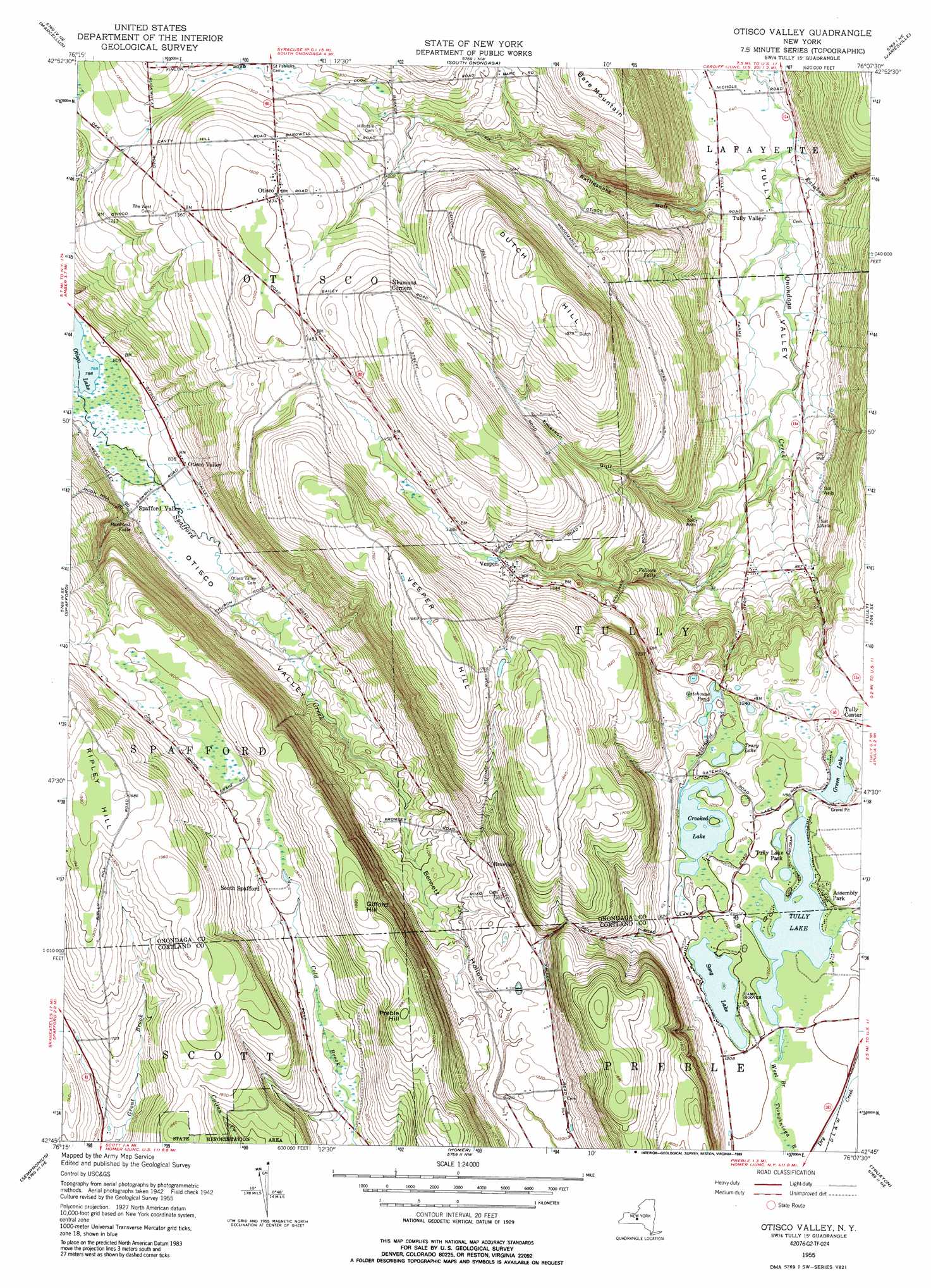
Otisco Valley Topo Map New York
To zoom in, hover over the map of Otisco Valley
USGS Topo Quad 42076g2 - 1:24,000 scale
| Topo Map Name: | Otisco Valley |
| USGS Topo Quad ID: | 42076g2 |
| Print Size: | ca. 21 1/4" wide x 27" high |
| Southeast Coordinates: | 42.75° N latitude / 76.125° W longitude |
| Map Center Coordinates: | 42.8125° N latitude / 76.1875° W longitude |
| U.S. State: | NY |
| Filename: | o42076g2.jpg |
| Download Map JPG Image: | Otisco Valley topo map 1:24,000 scale |
| Map Type: | Topographic |
| Topo Series: | 7.5´ |
| Map Scale: | 1:24,000 |
| Source of Map Images: | United States Geological Survey (USGS) |
| Alternate Map Versions: |
Otisco Valley NY 1955, updated 1956 Download PDF Buy paper map Otisco Valley NY 1955, updated 1962 Download PDF Buy paper map Otisco Valley NY 1955, updated 1971 Download PDF Buy paper map Otisco Valley NY 1955, updated 1989 Download PDF Buy paper map Otisco Valley NY 2010 Download PDF Buy paper map Otisco Valley NY 2013 Download PDF Buy paper map Otisco Valley NY 2016 Download PDF Buy paper map |
1:24,000 Topo Quads surrounding Otisco Valley
Jordan |
Camillus |
Syracuse West |
Syracuse East |
Manlius |
Skaneateles |
Marcellus |
South Onondaga |
Jamesville |
Oran |
Owasco |
Spafford |
Otisco Valley |
Tully |
De Ruyter |
Moravia |
Sempronius |
Homer |
Truxton |
Cuyler |
West Groton |
Groton |
Cortland |
Mcgraw |
Cincinnatus |
> Back to 42076e1 at 1:100,000 scale
> Back to 42076a1 at 1:250,000 scale
> Back to U.S. Topo Maps home
Otisco Valley topo map: Gazetteer
Otisco Valley: Falls
Bucktail Falls elevation 271m 889′Fellows Falls elevation 262m 859′
Otisco Valley: Lakes
Crooked Lake elevation 363m 1190′Gatehouse Pond elevation 364m 1194′
Green Lake elevation 363m 1190′
Song Lake elevation 364m 1194′
Tracy Lake elevation 365m 1197′
Tully Lake elevation 362m 1187′
Otisco Valley: Populated Places
Assembly Park elevation 366m 1200′Bromley elevation 392m 1286′
Otisco elevation 451m 1479′
Otisco Valley elevation 256m 839′
South Spafford elevation 467m 1532′
Spafford Valley elevation 261m 856′
Tully Lake Park elevation 364m 1194′
Vesper elevation 412m 1351′
Otisco Valley: Streams
Rainbow Creek elevation 164m 538′Spafford Creek elevation 240m 787′
Otisco Valley: Summits
Bare Mountain elevation 489m 1604′Dutch Hill elevation 570m 1870′
Gifford Hill elevation 576m 1889′
Preble Hill elevation 580m 1902′
Ripley Hill elevation 604m 1981′
Vesper Hill elevation 579m 1899′
Otisco Valley: Valleys
Bennett Hollow elevation 320m 1049′Emerson Gulf elevation 198m 649′
Otisco Valley elevation 240m 787′
Rattlesnake Gulf elevation 194m 636′
Otisco Valley digital topo map on disk
Buy this Otisco Valley topo map showing relief, roads, GPS coordinates and other geographical features, as a high-resolution digital map file on DVD:
New York, Vermont, Connecticut & Western Massachusetts
Buy digital topo maps: New York, Vermont, Connecticut & Western Massachusetts