Scipio Center Topo Map New York
To zoom in, hover over the map of Scipio Center
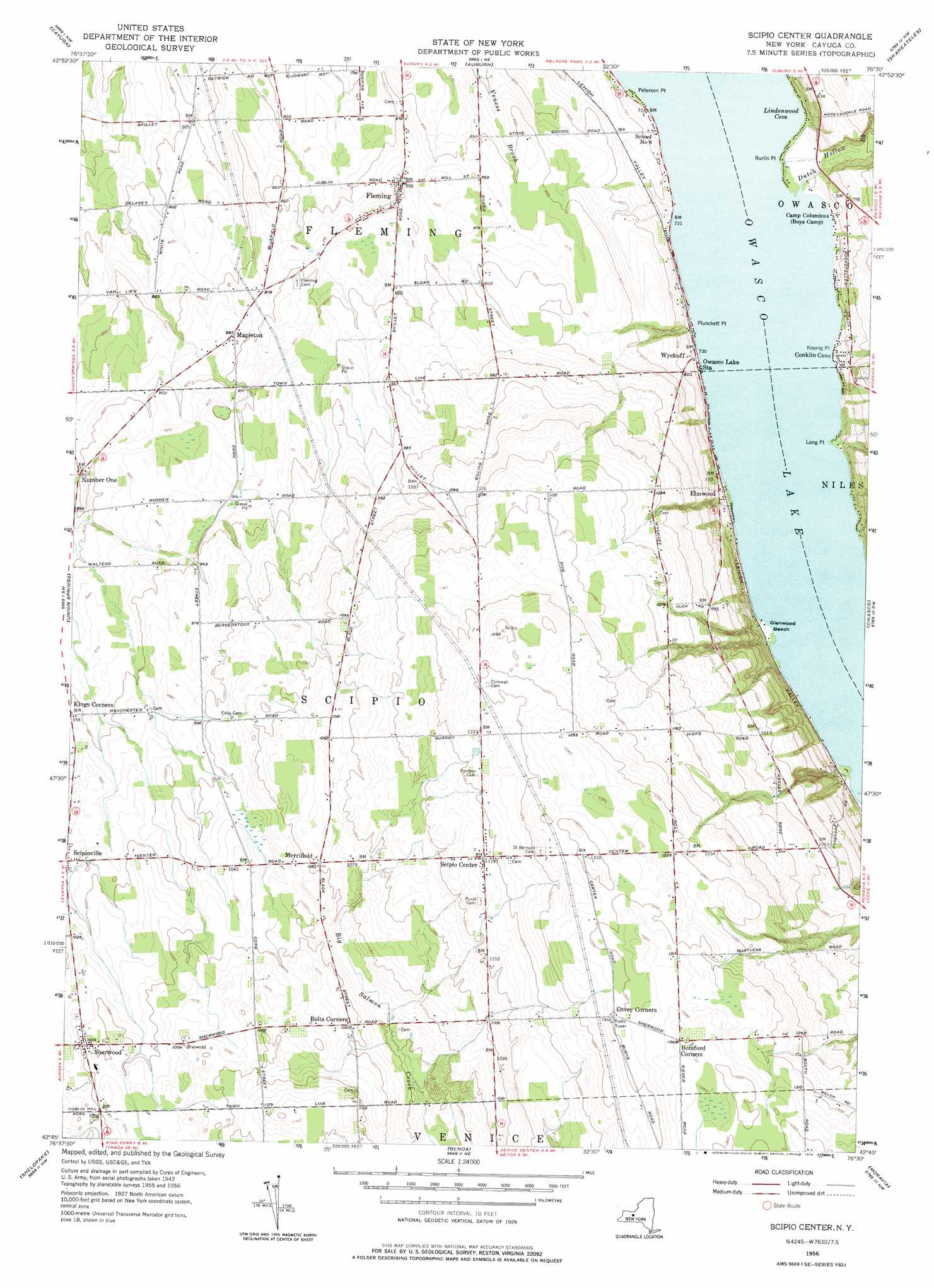
USGS Topo Quad 42076g5 - 1:24,000 scale
| Topo Map Name: | Scipio Center |
| USGS Topo Quad ID: | 42076g5 |
| Print Size: | ca. 21 1/4" wide x 27" high |
| Southeast Coordinates: | 42.75° N latitude / 76.5° W longitude |
| Map Center Coordinates: | 42.8125° N latitude / 76.5625° W longitude |
| U.S. State: | NY |
| Filename: | o42076g5.jpg |
| Download Map JPG Image: | Scipio Center topo map 1:24,000 scale |
| Map Type: | Topographic |
| Topo Series: | 7.5´ |
| Map Scale: | 1:24,000 |
| Source of Map Images: | United States Geological Survey (USGS) |
| Alternate Map Versions: |
Scipio Center NY 1956, updated 1957 Download PDF Buy paper map Scipio Center NY 1956, updated 1976 Download PDF Buy paper map Scipio Center NY 2010 Download PDF Buy paper map Scipio Center NY 2013 Download PDF Buy paper map Scipio Center NY 2016 Download PDF Buy paper map |
1:24,000 Topo Quads surrounding Scipio Center
Savannah |
Montezuma |
Weedsport |
Jordan |
Camillus |
Seneca Falls |
Cayuga |
Auburn |
Skaneateles |
Marcellus |
Romulus |
Union Springs |
Scipio Center |
Owasco |
Spafford |
Ovid |
Sheldrake |
Genoa |
Moravia |
Sempronius |
Lodi |
Trumansburg |
Ludlowville |
West Groton |
Groton |
> Back to 42076e1 at 1:100,000 scale
> Back to 42076a1 at 1:250,000 scale
> Back to U.S. Topo Maps home
Scipio Center topo map: Gazetteer
Scipio Center: Airports
Killian Airfield elevation 331m 1085′Scipio Center: Bays
Lindenwood Cove elevation 217m 711′Scipio Center: Beaches
Glenwood Beach elevation 219m 718′Scipio Center: Capes
Burtis Point elevation 217m 711′Ensenore Point elevation 217m 711′
Fays Point elevation 217m 711′
Glenwood Point elevation 219m 718′
Koenig Point elevation 218m 715′
Long Point elevation 217m 711′
Peterson Point elevation 217m 711′
Plunckett Point elevation 218m 715′
Scipio Center: Populated Places
Conklin Cove elevation 221m 725′Elmwood elevation 238m 780′
Ensenore elevation 223m 731′
Fleming elevation 275m 902′
Mapleton elevation 270m 885′
Merrifield elevation 322m 1056′
Owasco Lake Station elevation 222m 728′
Scipio Center elevation 363m 1190′
Scipioville elevation 300m 984′
Sherwood elevation 321m 1053′
Wyckoff elevation 226m 741′
Scipio Center: Reservoirs
Woods Mill Pond (historical) elevation 301m 987′Scipio Center: Streams
Dutch Hollow Brook elevation 217m 711′Scipio Center digital topo map on disk
Buy this Scipio Center topo map showing relief, roads, GPS coordinates and other geographical features, as a high-resolution digital map file on DVD:
New York, Vermont, Connecticut & Western Massachusetts
Buy digital topo maps: New York, Vermont, Connecticut & Western Massachusetts