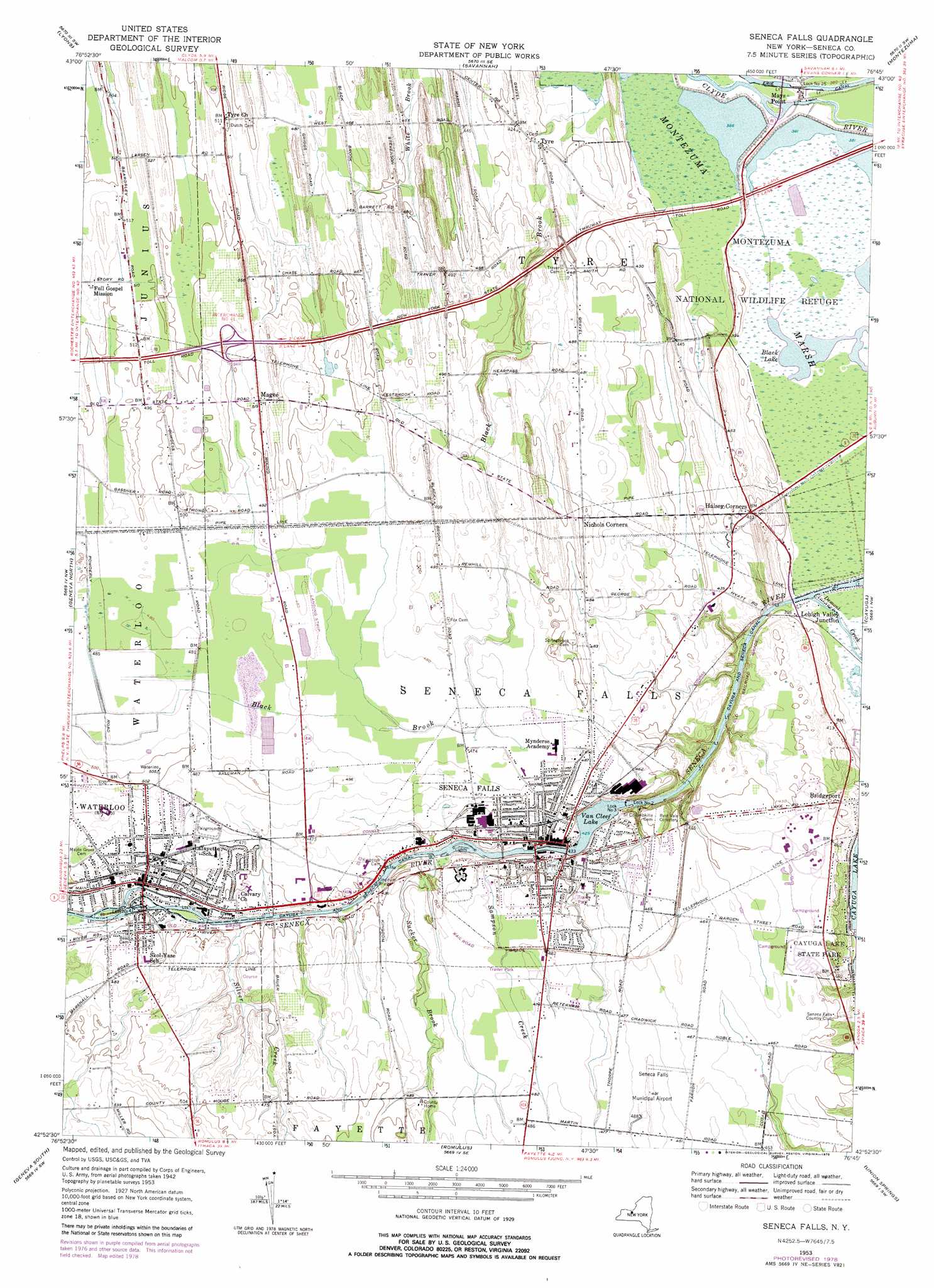
Seneca Falls Topo Map New York
To zoom in, hover over the map of Seneca Falls
USGS Topo Quad 42076h7 - 1:24,000 scale
| Topo Map Name: | Seneca Falls |
| USGS Topo Quad ID: | 42076h7 |
| Print Size: | ca. 21 1/4" wide x 27" high |
| Southeast Coordinates: | 42.875° N latitude / 76.75° W longitude |
| Map Center Coordinates: | 42.9375° N latitude / 76.8125° W longitude |
| U.S. State: | NY |
| Filename: | o42076h7.jpg |
| Download Map JPG Image: | Seneca Falls topo map 1:24,000 scale |
| Map Type: | Topographic |
| Topo Series: | 7.5´ |
| Map Scale: | 1:24,000 |
| Source of Map Images: | United States Geological Survey (USGS) |
| Alternate Map Versions: |
Seneca Falls NY 1943, updated 1954 Download PDF Buy paper map Seneca Falls NY 1953, updated 1955 Download PDF Buy paper map Seneca Falls NY 1953, updated 1970 Download PDF Buy paper map Seneca Falls NY 1953, updated 1979 Download PDF Buy paper map Seneca Falls NY 1953, updated 1979 Download PDF Buy paper map Seneca Falls NY 2010 Download PDF Buy paper map Seneca Falls NY 2013 Download PDF Buy paper map Seneca Falls NY 2016 Download PDF Buy paper map |
1:24,000 Topo Quads surrounding Seneca Falls
Sodus |
Rose |
Wolcott |
Victory |
Cato |
Newark |
Lyons |
Savannah |
Montezuma |
Weedsport |
Phelps |
Geneva North |
Seneca Falls |
Cayuga |
Auburn |
Stanley |
Geneva South |
Romulus |
Union Springs |
Scipio Center |
Penn Yan |
Dresden |
Ovid |
Sheldrake |
Genoa |
> Back to 42076e1 at 1:100,000 scale
> Back to 42076a1 at 1:250,000 scale
> Back to U.S. Topo Maps home
Seneca Falls topo map: Gazetteer
Seneca Falls: Airports
Fingerlakes Regional Airport elevation 150m 492′Seneca Falls Municipal Airport elevation 150m 492′
Seneca Falls: Bridges
Kingdom Bridge elevation 131m 429′Seneca Falls: Canals
Cayuga and Seneca Canal elevation 119m 390′Seneca Falls: Crossings
Interchange Number 41 elevation 155m 508′Seneca Falls: Dams
Lock Number 2 elevation 119m 390′Lock Number 25 elevation 118m 387′
Lock Number 3 elevation 131m 429′
Lock Number 4 elevation 134m 439′
Seneca Falls: Lakes
Black Lake elevation 116m 380′Seneca Falls: Parks
Cayuga Lake State Park elevation 140m 459′Lafayette Park elevation 139m 456′
Montezuma National Wildlife Refuge elevation 116m 380′
Women's Rights National Historical Park elevation 139m 456′
Seneca Falls: Populated Places
Bridgeport elevation 133m 436′Lehigh Valley Junction elevation 152m 498′
Magee elevation 158m 518′
Mays Point elevation 116m 380′
Seneca Falls elevation 137m 449′
Tyre elevation 125m 410′
Waterloo elevation 138m 452′
Seneca Falls: Reservoirs
Van Cleef Lake elevation 124m 406′Seneca Falls: Streams
Black Brook elevation 117m 383′Sampson Creek elevation 132m 433′
Silver Creek elevation 131m 429′
Sucker Brook elevation 131m 429′
Seneca Falls: Swamps
Montezuma Marsh elevation 116m 380′Seneca Falls digital topo map on disk
Buy this Seneca Falls topo map showing relief, roads, GPS coordinates and other geographical features, as a high-resolution digital map file on DVD:
New York, Vermont, Connecticut & Western Massachusetts
Buy digital topo maps: New York, Vermont, Connecticut & Western Massachusetts