Clifton Springs Topo Map New York
To zoom in, hover over the map of Clifton Springs
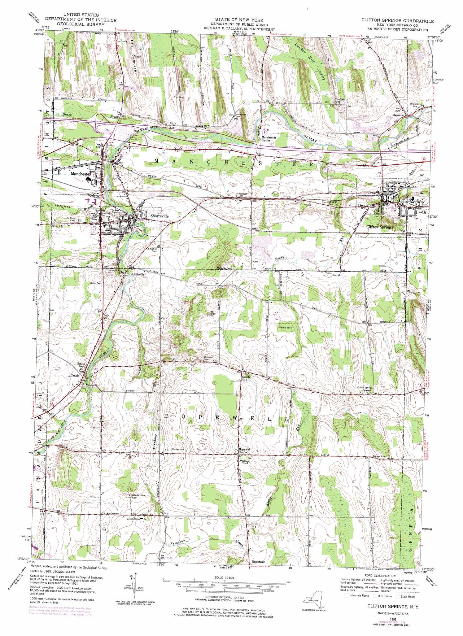
USGS Topo Quad 42077h2 - 1:24,000 scale
| Topo Map Name: | Clifton Springs |
| USGS Topo Quad ID: | 42077h2 |
| Print Size: | ca. 21 1/4" wide x 27" high |
| Southeast Coordinates: | 42.875° N latitude / 77.125° W longitude |
| Map Center Coordinates: | 42.9375° N latitude / 77.1875° W longitude |
| U.S. State: | NY |
| Filename: | o42077h2.jpg |
| Download Map JPG Image: | Clifton Springs topo map 1:24,000 scale |
| Map Type: | Topographic |
| Topo Series: | 7.5´ |
| Map Scale: | 1:24,000 |
| Source of Map Images: | United States Geological Survey (USGS) |
| Alternate Map Versions: |
Clifton Springs NY 1951, updated 1953 Download PDF Buy paper map Clifton Springs NY 1951, updated 1974 Download PDF Buy paper map Clifton Springs NY 1951, updated 1978 Download PDF Buy paper map Clifton Springs NY 2010 Download PDF Buy paper map Clifton Springs NY 2013 Download PDF Buy paper map Clifton Springs NY 2016 Download PDF Buy paper map |
1:24,000 Topo Quads surrounding Clifton Springs
Webster |
Ontario |
Williamson |
Sodus |
Rose |
Fairport |
Macedon |
Palmyra |
Newark |
Lyons |
Victor |
Canandaigua |
Clifton Springs |
Phelps |
Geneva North |
Bristol Center |
Canandaigua Lake |
Rushville |
Stanley |
Geneva South |
Bristol Springs |
Middlesex |
Potter |
Penn Yan |
Dresden |
> Back to 42077e1 at 1:100,000 scale
> Back to 42076a1 at 1:250,000 scale
> Back to U.S. Topo Maps home
Clifton Springs topo map: Gazetteer
Clifton Springs: Airports
Hopewell Airpark elevation 220m 721′Clifton Springs: Populated Places
Chapin elevation 214m 702′Clifton Springs elevation 176m 577′
Ennerdale elevation 258m 846′
Gypsum elevation 159m 521′
Hopewell Center elevation 255m 836′
Littleville elevation 196m 643′
Manchester elevation 180m 590′
Manchester Center elevation 167m 547′
Shortsville elevation 189m 620′
Clifton Springs: Reservoirs
Clifton Springs Reservoir elevation 241m 790′Clifton Springs: Streams
Black Brook elevation 166m 544′Freshour Creek elevation 200m 656′
Padelford Brook elevation 175m 574′
Rocky Run elevation 158m 518′
Sulphur Creek elevation 154m 505′
Clifton Springs: Summits
Bunker Hill elevation 176m 577′Hill Cumorah elevation 208m 682′
Clifton Springs: Swamps
Bunker Hill Swamp elevation 162m 531′Clifton Springs digital topo map on disk
Buy this Clifton Springs topo map showing relief, roads, GPS coordinates and other geographical features, as a high-resolution digital map file on DVD:
New York, Vermont, Connecticut & Western Massachusetts
Buy digital topo maps: New York, Vermont, Connecticut & Western Massachusetts