Caledonia Topo Map New York
To zoom in, hover over the map of Caledonia
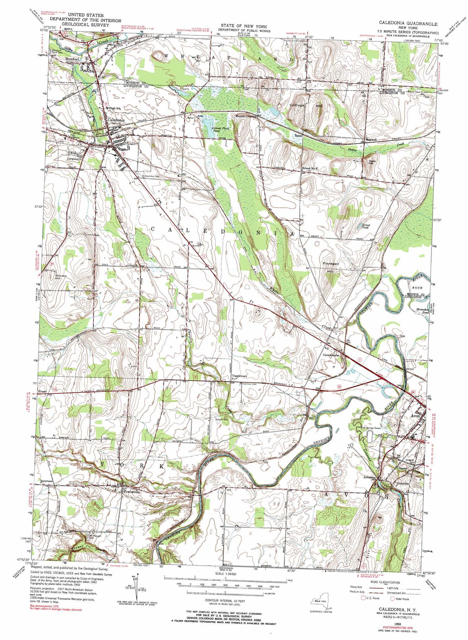
USGS Topo Quad 42077h7 - 1:24,000 scale
| Topo Map Name: | Caledonia |
| USGS Topo Quad ID: | 42077h7 |
| Print Size: | ca. 21 1/4" wide x 27" high |
| Southeast Coordinates: | 42.875° N latitude / 77.75° W longitude |
| Map Center Coordinates: | 42.9375° N latitude / 77.8125° W longitude |
| U.S. State: | NY |
| Filename: | o42077h7.jpg |
| Download Map JPG Image: | Caledonia topo map 1:24,000 scale |
| Map Type: | Topographic |
| Topo Series: | 7.5´ |
| Map Scale: | 1:24,000 |
| Source of Map Images: | United States Geological Survey (USGS) |
| Alternate Map Versions: |
Caledonia NY 1950, updated 1952 Download PDF Buy paper map Caledonia NY 1950, updated 1964 Download PDF Buy paper map Caledonia NY 1950, updated 1970 Download PDF Buy paper map Caledonia NY 1950, updated 1970 Download PDF Buy paper map Caledonia NY 2010 Download PDF Buy paper map Caledonia NY 2013 Download PDF Buy paper map Caledonia NY 2016 Download PDF Buy paper map |
1:24,000 Topo Quads surrounding Caledonia
Holley |
Brockport |
Spencerport |
Rochester West |
Rochester East |
Byron |
Churchville |
Clifton |
West Henrietta |
Pittsford |
Stafford |
Le Roy |
Caledonia |
Rush |
Honeoye Falls |
Wyoming |
Leicester |
Geneseo |
Livonia |
Honeoye |
Castile |
Mount Morris |
Sonyea |
Conesus |
Springwater |
> Back to 42077e1 at 1:100,000 scale
> Back to 42076a1 at 1:250,000 scale
> Back to U.S. Topo Maps home
Caledonia topo map: Gazetteer
Caledonia: Lakes
Cement Plant Pond elevation 187m 613′Grant Pond elevation 189m 620′
Caledonia: Mines
Caledonia Quarry elevation 180m 590′Caledonia: Populated Places
Ashantee elevation 177m 580′Baker elevation 183m 600′
Caledonia elevation 201m 659′
Canawaugus elevation 180m 590′
Fowlerville elevation 194m 636′
Fraser elevation 221m 725′
Inverness elevation 217m 711′
Littleville elevation 191m 626′
Maxwell elevation 180m 590′
Menzie Crossing elevation 186m 610′
Mumford elevation 188m 616′
Toggletown elevation 185m 606′
Caledonia: Streams
Christie Creek elevation 159m 521′Conesus Creek elevation 158m 518′
Little Conesus Creek elevation 164m 538′
White Creek elevation 158m 518′
Caledonia: Summits
Collings Hill elevation 233m 764′Davis Hill elevation 214m 702′
Finnegan Hill elevation 212m 695′
Sinclair Hill elevation 245m 803′
Caledonia digital topo map on disk
Buy this Caledonia topo map showing relief, roads, GPS coordinates and other geographical features, as a high-resolution digital map file on DVD:
New York, Vermont, Connecticut & Western Massachusetts
Buy digital topo maps: New York, Vermont, Connecticut & Western Massachusetts