Red House Topo Map New York
To zoom in, hover over the map of Red House
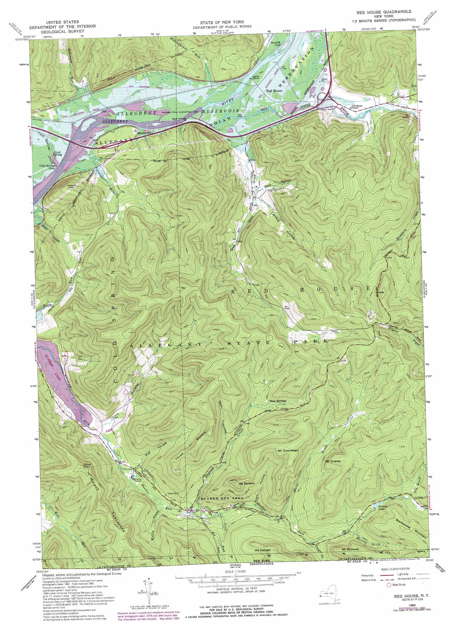
USGS Topo Quad 42078a7 - 1:24,000 scale
| Topo Map Name: | Red House |
| USGS Topo Quad ID: | 42078a7 |
| Print Size: | ca. 21 1/4" wide x 27" high |
| Southeast Coordinates: | 42° N latitude / 78.75° W longitude |
| Map Center Coordinates: | 42.0625° N latitude / 78.8125° W longitude |
| U.S. State: | NY |
| Filename: | o42078a7.jpg |
| Download Map JPG Image: | Red House topo map 1:24,000 scale |
| Map Type: | Topographic |
| Topo Series: | 7.5´ |
| Map Scale: | 1:24,000 |
| Source of Map Images: | United States Geological Survey (USGS) |
| Alternate Map Versions: |
Red House NY 1962, updated 1964 Download PDF Buy paper map Red House NY 1962, updated 1980 Download PDF Buy paper map Red House NY 1962, updated 1991 Download PDF Buy paper map Red House NY 1962, updated 1991 Download PDF Buy paper map Red House NY 2010 Download PDF Buy paper map Red House NY 2013 Download PDF Buy paper map Red House NY 2016 Download PDF Buy paper map |
1:24,000 Topo Quads surrounding Red House
Cherry Creek |
New Albion |
Cattaraugus |
Ellicottville |
Ashford |
Kennedy |
Randolph |
Little Valley |
Salamanca |
Humphrey |
Ivory |
Steamburg |
Red House |
Limestone |
Knapp Creek |
Scandia |
Cornplanter Run |
Stickney |
Bradford |
Derrick City |
Clarendon |
Cornplanter Bridge |
Westline |
Lewis Run |
Cyclone |
> Back to 42078a1 at 1:100,000 scale
> Back to 42078a1 at 1:250,000 scale
> Back to U.S. Topo Maps home
Red House topo map: Gazetteer
Red House: Areas
Quaker Run Area elevation 484m 1587′Red House: Bays
Cold Spring Cove elevation 401m 1315′Sunfish Cove elevation 414m 1358′
Red House: Capes
Red House Point elevation 406m 1332′Red House: Cliffs
Witchs Walk elevation 409m 1341′Red House: Parks
Allegany State Park elevation 672m 2204′Red House: Populated Places
Cold Spring elevation 409m 1341′Red House elevation 408m 1338′
Red House: Reservoirs
Science Lake elevation 567m 1860′Red House: Springs
Bear Springs elevation 574m 1883′Red House: Streams
Bay State Brook elevation 405m 1328′Cold Spring Creek elevation 401m 1315′
Coon Run elevation 460m 1509′
Cricks Run elevation 401m 1315′
Dry Brook elevation 584m 1916′
English Creek elevation 451m 1479′
Meetinghouse Run elevation 407m 1335′
Murray Brook elevation 531m 1742′
Red House Brook elevation 408m 1338′
Robinson Run elevation 401m 1315′
Stony Brook elevation 487m 1597′
Sunfish Run elevation 409m 1341′
Willis Creek elevation 545m 1788′
Willis Creek elevation 443m 1453′
Wolf Run elevation 504m 1653′
Yeager Brook elevation 523m 1715′
Yeager Brook elevation 510m 1673′
Red House: Summits
Blacksnake Mountain elevation 676m 2217′Mount Cayuga elevation 631m 2070′
Mount Mohawk elevation 632m 2073′
Mount Oneida elevation 665m 2181′
Mount Onondaga elevation 672m 2204′
Mount Seneca elevation 642m 2106′
Mount Tuscarora elevation 653m 2142′
Three Sisters elevation 642m 2106′
Red House: Trails
Trail Number 1 elevation 470m 1541′Trail Number 10 elevation 589m 1932′
Trail Number 2 elevation 545m 1788′
Trail Number 4 elevation 579m 1899′
Trail Number 4 elevation 690m 2263′
Trail Number 4 A elevation 586m 1922′
Trail Number 5 elevation 677m 2221′
Trail Number 9 elevation 679m 2227′
Red House: Valleys
Beck Hollow elevation 426m 1397′Cain Hollow elevation 420m 1377′
Fox Hollow elevation 430m 1410′
Holt Hollow elevation 510m 1673′
Lonkto Hollow elevation 428m 1404′
Slide Hollow elevation 475m 1558′
Red House digital topo map on disk
Buy this Red House topo map showing relief, roads, GPS coordinates and other geographical features, as a high-resolution digital map file on DVD:
 map DVD")