Wyoming Topo Map New York
To zoom in, hover over the map of Wyoming
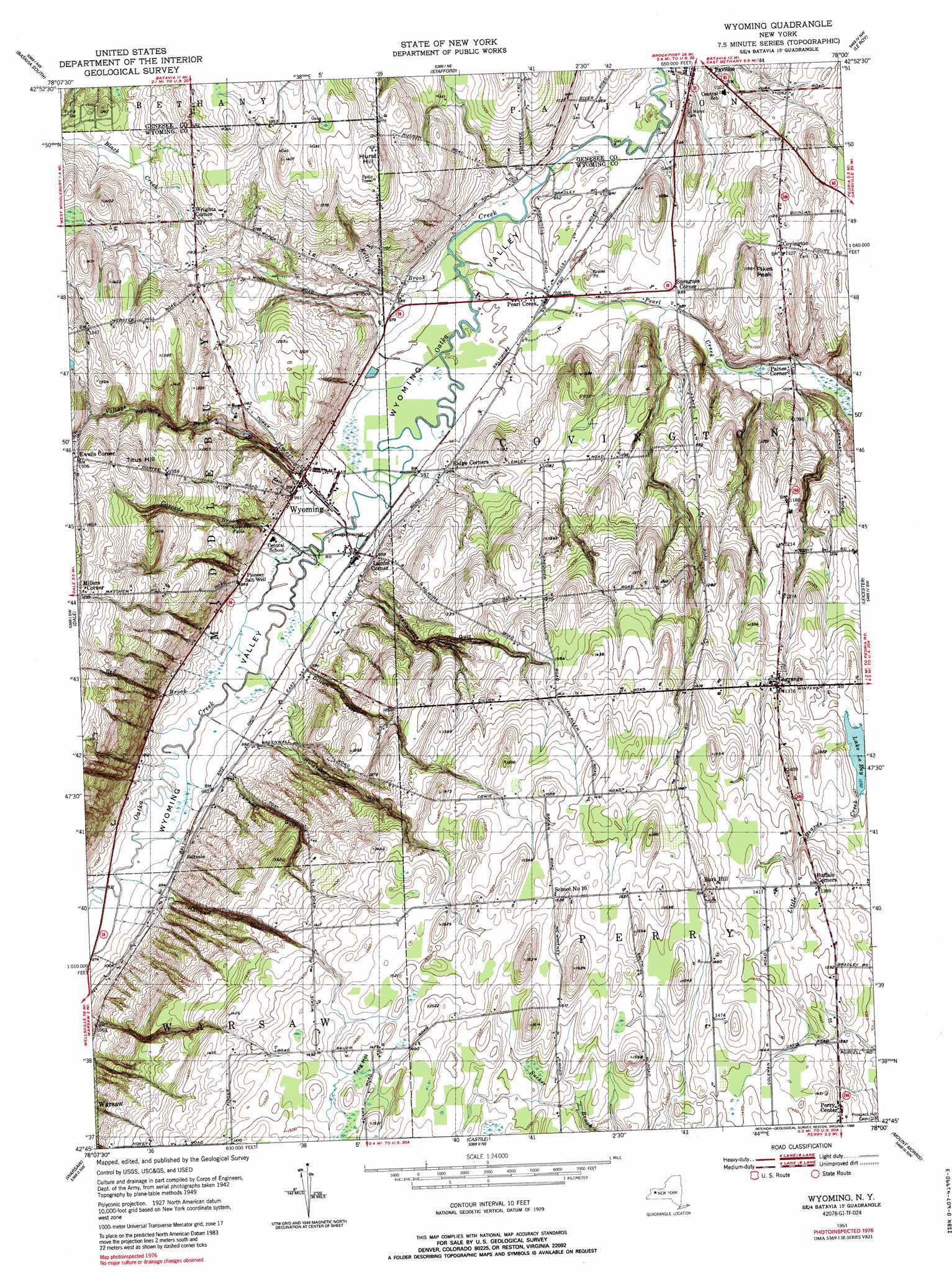
USGS Topo Quad 42078g1 - 1:24,000 scale
| Topo Map Name: | Wyoming |
| USGS Topo Quad ID: | 42078g1 |
| Print Size: | ca. 21 1/4" wide x 27" high |
| Southeast Coordinates: | 42.75° N latitude / 78° W longitude |
| Map Center Coordinates: | 42.8125° N latitude / 78.0625° W longitude |
| U.S. State: | NY |
| Filename: | o42078g1.jpg |
| Download Map JPG Image: | Wyoming topo map 1:24,000 scale |
| Map Type: | Topographic |
| Topo Series: | 7.5´ |
| Map Scale: | 1:24,000 |
| Source of Map Images: | United States Geological Survey (USGS) |
| Alternate Map Versions: |
Wyoming NY 1951 Download PDF Buy paper map Wyoming NY 1951 Download PDF Buy paper map Wyoming NY 1951, updated 1989 Download PDF Buy paper map Wyoming NY 1951, updated 1989 Download PDF Buy paper map Wyoming NY 2010 Download PDF Buy paper map Wyoming NY 2013 Download PDF Buy paper map Wyoming NY 2016 Download PDF Buy paper map |
1:24,000 Topo Quads surrounding Wyoming
Oakfield |
Batavia North |
Byron |
Churchville |
Clifton |
Alexander |
Batavia South |
Stafford |
Le Roy |
Caledonia |
Attica |
Dale |
Wyoming |
Leicester |
Geneseo |
Johnsonburg |
Warsaw |
Castile |
Mount Morris |
Sonyea |
Bliss |
Pike |
Portageville |
Nunda |
Ossian |
> Back to 42078e1 at 1:100,000 scale
> Back to 42078a1 at 1:250,000 scale
> Back to U.S. Topo Maps home
Wyoming topo map: Gazetteer
Wyoming: Falls
Cascade Falls elevation 343m 1125′Wyoming: Parks
Wyoming Village Historic District elevation 302m 990′Wyoming: Populated Places
Buffalo Corners elevation 426m 1397′Burk Hill elevation 458m 1502′
Covington elevation 336m 1102′
Ewells Corner elevation 459m 1505′
Hilltop Acres Mobile Home Park elevation 372m 1220′
Lagrange elevation 403m 1322′
Lambs Corner elevation 298m 977′
Millers Corner elevation 468m 1535′
Paines Corner elevation 302m 990′
Pearl Creek elevation 289m 948′
Saltvale elevation 302m 990′
Spragues Corner elevation 301m 987′
Wrights Corner elevation 373m 1223′
Wyoming elevation 301m 987′
Wyoming: Streams
Cascade Brook elevation 288m 944′Kelly Brook elevation 285m 935′
Pearl Creek elevation 285m 935′
Red Brook elevation 292m 958′
Village Brook elevation 288m 944′
Wyoming: Summits
Hurst Hill elevation 412m 1351′Pikes Peak elevation 361m 1184′
Titus Hill elevation 464m 1522′
Wyoming: Valleys
Canaway Gulf elevation 301m 987′Dillon Gulf elevation 298m 977′
Frog Hollow elevation 450m 1476′
Handyside Gulf elevation 302m 990′
Holihan Gulf elevation 304m 997′
Holstead Gulf elevation 301m 987′
Wyoming Gulf elevation 306m 1003′
Wyoming Valley elevation 287m 941′
Wyoming digital topo map on disk
Buy this Wyoming topo map showing relief, roads, GPS coordinates and other geographical features, as a high-resolution digital map file on DVD:
 map DVD")