Lakewood Topo Map New York
To zoom in, hover over the map of Lakewood
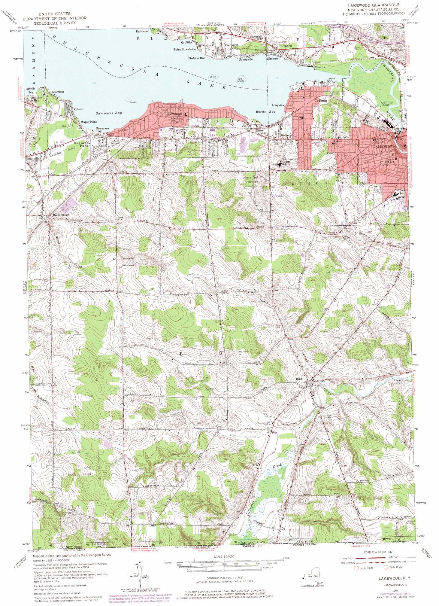
USGS Topo Quad 42079a3 - 1:24,000 scale
| Topo Map Name: | Lakewood |
| USGS Topo Quad ID: | 42079a3 |
| Print Size: | ca. 21 1/4" wide x 27" high |
| Southeast Coordinates: | 42° N latitude / 79.25° W longitude |
| Map Center Coordinates: | 42.0625° N latitude / 79.3125° W longitude |
| U.S. State: | NY |
| Filename: | o42079a3.jpg |
| Download Map JPG Image: | Lakewood topo map 1:24,000 scale |
| Map Type: | Topographic |
| Topo Series: | 7.5´ |
| Map Scale: | 1:24,000 |
| Source of Map Images: | United States Geological Survey (USGS) |
| Alternate Map Versions: |
Lakewood NY 1954, updated 1957 Download PDF Buy paper map Lakewood NY 1954, updated 1967 Download PDF Buy paper map Lakewood NY 1954, updated 1977 Download PDF Buy paper map Lakewood NY 1954, updated 1980 Download PDF Buy paper map Lakewood NY 2010 Download PDF Buy paper map Lakewood NY 2013 Download PDF Buy paper map Lakewood NY 2016 Download PDF Buy paper map |
1:24,000 Topo Quads surrounding Lakewood
Westfield |
Hartfield |
Cassadaga |
Hamlet |
Cherry Creek |
Sherman |
Chautauqua |
Ellery Center |
Gerry |
Kennedy |
North Clymer |
Panama |
Lakewood |
Jamestown |
Ivory |
Columbus |
Lottsville |
Sugar Grove |
Russell |
Scandia |
Spring Creek |
Pittsfield |
Youngsville |
Warren |
Clarendon |
> Back to 42079a1 at 1:100,000 scale
> Back to 42078a1 at 1:250,000 scale
> Back to U.S. Topo Maps home
Lakewood topo map: Gazetteer
Lakewood: Airports
Ridgeview Airport elevation 493m 1617′Lakewood: Bays
Burtis Bay elevation 399m 1309′Shermans Bay elevation 399m 1309′
Lakewood: Parks
Celoron Park (historical) elevation 400m 1312′Lakewood: Populated Places
Arowley Manor elevation 424m 1391′Bonila elevation 400m 1312′
Boomertown elevation 424m 1391′
Busti elevation 416m 1364′
Celoron elevation 402m 1318′
Cottage Park elevation 399m 1309′
Driftwood elevation 403m 1322′
Elmhurst elevation 399m 1309′
Fluvanna elevation 408m 1338′
Greenhurst elevation 402m 1318′
Griffiths elevation 399m 1309′
Lakewood elevation 404m 1325′
Longview elevation 400m 1312′
Loomises elevation 399m 1309′
Maple Point elevation 399m 1309′
Monticello Mobile Home Park elevation 402m 1318′
Point Stockholm elevation 400m 1312′
Sheldon Hall elevation 400m 1312′
Shermans Bay elevation 403m 1322′
Sunnyside elevation 399m 1309′
Vukote elevation 401m 1315′
Lakewood: Streams
Dutch Hollow Creek elevation 399m 1309′Goose Creek elevation 399m 1309′
Goose Creek elevation 402m 1318′
Hatch Creek elevation 400m 1312′
Lakewood digital topo map on disk
Buy this Lakewood topo map showing relief, roads, GPS coordinates and other geographical features, as a high-resolution digital map file on DVD:
 map DVD")