Panama Topo Map New York
To zoom in, hover over the map of Panama
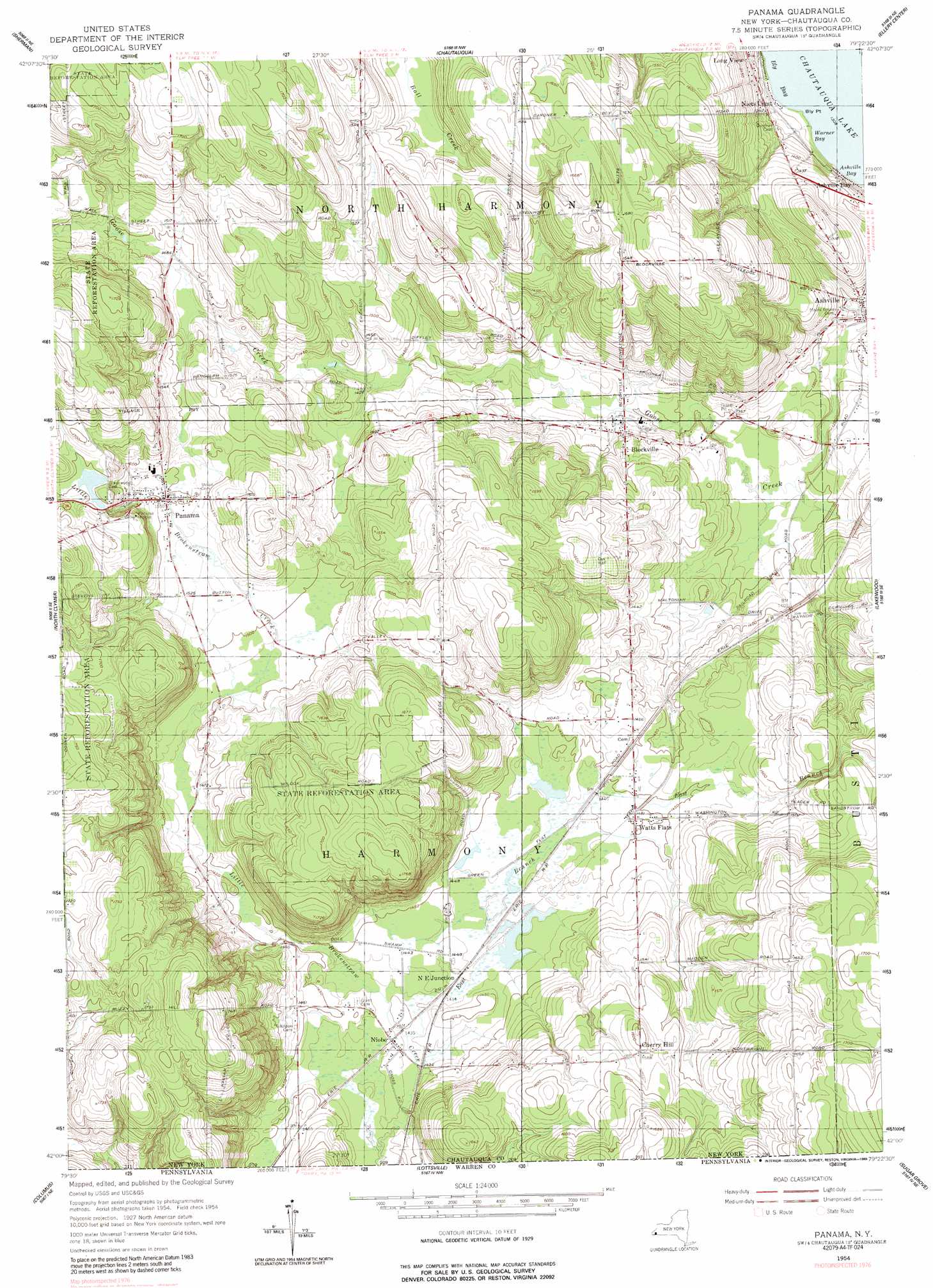
USGS Topo Quad 42079a4 - 1:24,000 scale
| Topo Map Name: | Panama |
| USGS Topo Quad ID: | 42079a4 |
| Print Size: | ca. 21 1/4" wide x 27" high |
| Southeast Coordinates: | 42° N latitude / 79.375° W longitude |
| Map Center Coordinates: | 42.0625° N latitude / 79.4375° W longitude |
| U.S. State: | NY |
| Filename: | o42079a4.jpg |
| Download Map JPG Image: | Panama topo map 1:24,000 scale |
| Map Type: | Topographic |
| Topo Series: | 7.5´ |
| Map Scale: | 1:24,000 |
| Source of Map Images: | United States Geological Survey (USGS) |
| Alternate Map Versions: |
Panama NY 1954, updated 1957 Download PDF Buy paper map Panama NY 1954, updated 1989 Download PDF Buy paper map Panama NY 2010 Download PDF Buy paper map Panama NY 2013 Download PDF Buy paper map Panama NY 2016 Download PDF Buy paper map |
1:24,000 Topo Quads surrounding Panama
Ripley |
Westfield |
Hartfield |
Cassadaga |
Hamlet |
South Ripley |
Sherman |
Chautauqua |
Ellery Center |
Gerry |
Clymer |
North Clymer |
Panama |
Lakewood |
Jamestown |
Corry |
Columbus |
Lottsville |
Sugar Grove |
Russell |
Spartansburg |
Spring Creek |
Pittsfield |
Youngsville |
Warren |
> Back to 42079a1 at 1:100,000 scale
> Back to 42078a1 at 1:250,000 scale
> Back to U.S. Topo Maps home
Panama topo map: Gazetteer
Panama: Airports
Fairbank Farms Airport elevation 407m 1335′Panama: Bays
Ashville Bay elevation 399m 1309′Warner Bay elevation 399m 1309′
Panama: Capes
Bly Point elevation 400m 1312′Panama: Cliffs
Panama Rocks elevation 491m 1610′Panama: Populated Places
Ashville elevation 414m 1358′Blockville elevation 424m 1391′
Cherry Hill elevation 485m 1591′
Long View elevation 421m 1381′
Niets Crest elevation 410m 1345′
Niobe elevation 436m 1430′
North East Junction elevation 438m 1437′
Panama elevation 473m 1551′
Watts Flats elevation 442m 1450′
Panama: Streams
East Branch Little Brokenstraw Creek elevation 436m 1430′Panama digital topo map on disk
Buy this Panama topo map showing relief, roads, GPS coordinates and other geographical features, as a high-resolution digital map file on DVD:
 map DVD")