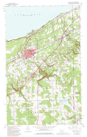
North East Topo Map Pennsylvania
To zoom in, hover over the map of North East
USGS Topo Quad 42079b7 - 1:24,000 scale
| Topo Map Name: | North East |
| USGS Topo Quad ID: | 42079b7 |
| Print Size: | ca. 21 1/4" wide x 27" high |
| Southeast Coordinates: | 42.125° N latitude / 79.75° W longitude |
| Map Center Coordinates: | 42.1875° N latitude / 79.8125° W longitude |
| U.S. States: | PA, NY |
| Filename: | o42079b7.jpg |
| Download Map JPG Image: | North East topo map 1:24,000 scale |
| Map Type: | Topographic |
| Topo Series: | 7.5´ |
| Map Scale: | 1:24,000 |
| Source of Map Images: | United States Geological Survey (USGS) |
| Alternate Map Versions: |
North East PA 2010 Download PDF Buy paper map North East PA 2013 Download PDF Buy paper map North East PA 2016 Download PDF Buy paper map |
1:24,000 Topo Quads surrounding North East
Ripley |
Westfield |
|||
Erie North |
Harborcreek |
North East |
South Ripley |
Sherman |
Erie South |
Hammett |
Wattsburg |
Clymer |
North Clymer |
Cambridge Springs Ne |
Waterford |
Union City |
Corry |
Columbus |
> Back to 42079a1 at 1:100,000 scale
> Back to 42078a1 at 1:250,000 scale
> Back to U.S. Topo Maps home
North East topo map: Gazetteer
North East: Airports
Papermill Hollow Airport (historical) elevation 250m 820′North East: Crossings
Interchange 11 elevation 332m 1089′Interchange 12 elevation 250m 820′
North East: Dams
Camp Cayuga Dam elevation 395m 1295′Eaton Dam elevation 433m 1420′
Grahamville Reservoir Dam elevation 381m 1250′
North East: Parks
Gibson Park elevation 242m 793′State Game Lands Number 163 elevation 445m 1459′
North East: Populated Places
Delhill Corners elevation 407m 1335′Freeport elevation 181m 593′
Kerrs Corners elevation 396m 1299′
North East elevation 243m 797′
Orchard Beach elevation 192m 629′
State Line elevation 233m 764′
North East: Reservoirs
Grahamville Reservoir elevation 377m 1236′Howard Eaton Reservoir elevation 433m 1420′
Smith Reservoir elevation 393m 1289′
North East: Streams
Sixteenmile Creek elevation 174m 570′North East: Valleys
Gage Gulf elevation 237m 777′North East digital topo map on disk
Buy this North East topo map showing relief, roads, GPS coordinates and other geographical features, as a high-resolution digital map file on DVD:


