Hamlet Topo Map New York
To zoom in, hover over the map of Hamlet
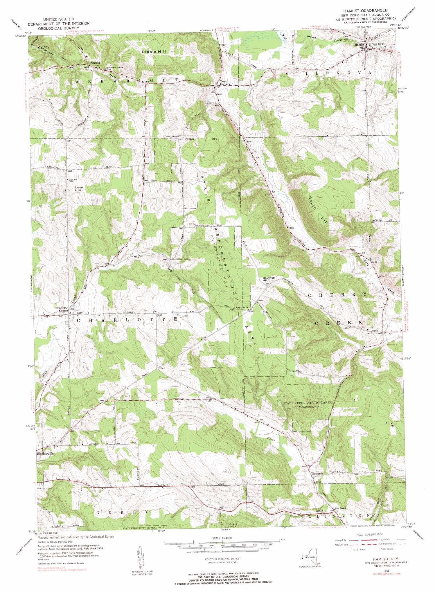
USGS Topo Quad 42079c2 - 1:24,000 scale
| Topo Map Name: | Hamlet |
| USGS Topo Quad ID: | 42079c2 |
| Print Size: | ca. 21 1/4" wide x 27" high |
| Southeast Coordinates: | 42.25° N latitude / 79.125° W longitude |
| Map Center Coordinates: | 42.3125° N latitude / 79.1875° W longitude |
| U.S. State: | NY |
| Filename: | o42079c2.jpg |
| Download Map JPG Image: | Hamlet topo map 1:24,000 scale |
| Map Type: | Topographic |
| Topo Series: | 7.5´ |
| Map Scale: | 1:24,000 |
| Source of Map Images: | United States Geological Survey (USGS) |
| Alternate Map Versions: |
Hamlet NY 1954, updated 1956 Download PDF Buy paper map Hamlet NY 1954, updated 1990 Download PDF Buy paper map Hamlet NY 2010 Download PDF Buy paper map Hamlet NY 2013 Download PDF Buy paper map Hamlet NY 2016 Download PDF Buy paper map |
1:24,000 Topo Quads surrounding Hamlet
North Of Dunkirk |
Silver Creek |
Farnham |
North Collins |
|
Brocton |
Dunkirk |
Forestville |
Perrysburg |
Gowanda |
Hartfield |
Cassadaga |
Hamlet |
Cherry Creek |
New Albion |
Chautauqua |
Ellery Center |
Gerry |
Kennedy |
Randolph |
Panama |
Lakewood |
Jamestown |
Ivory |
Steamburg |
> Back to 42079a1 at 1:100,000 scale
> Back to 42078a1 at 1:250,000 scale
> Back to U.S. Topo Maps home
Hamlet topo map: Gazetteer
Hamlet: Populated Places
Bates elevation 475m 1558′Charlotte Center elevation 467m 1532′
Griswold elevation 437m 1433′
Hamlet elevation 426m 1397′
Thornton elevation 477m 1564′
Hamlet: Streams
Markum Brook elevation 405m 1328′Hamlet: Summits
Arab Hill elevation 640m 2099′Boutwell Hill elevation 635m 2083′
Dibble Hill elevation 579m 1899′
Luce Hill elevation 605m 1984′
Pickup Hill elevation 630m 2066′
South Hill elevation 591m 1938′
Hamlet digital topo map on disk
Buy this Hamlet topo map showing relief, roads, GPS coordinates and other geographical features, as a high-resolution digital map file on DVD:
 map DVD")