Westfield Topo Map New York
To zoom in, hover over the map of Westfield
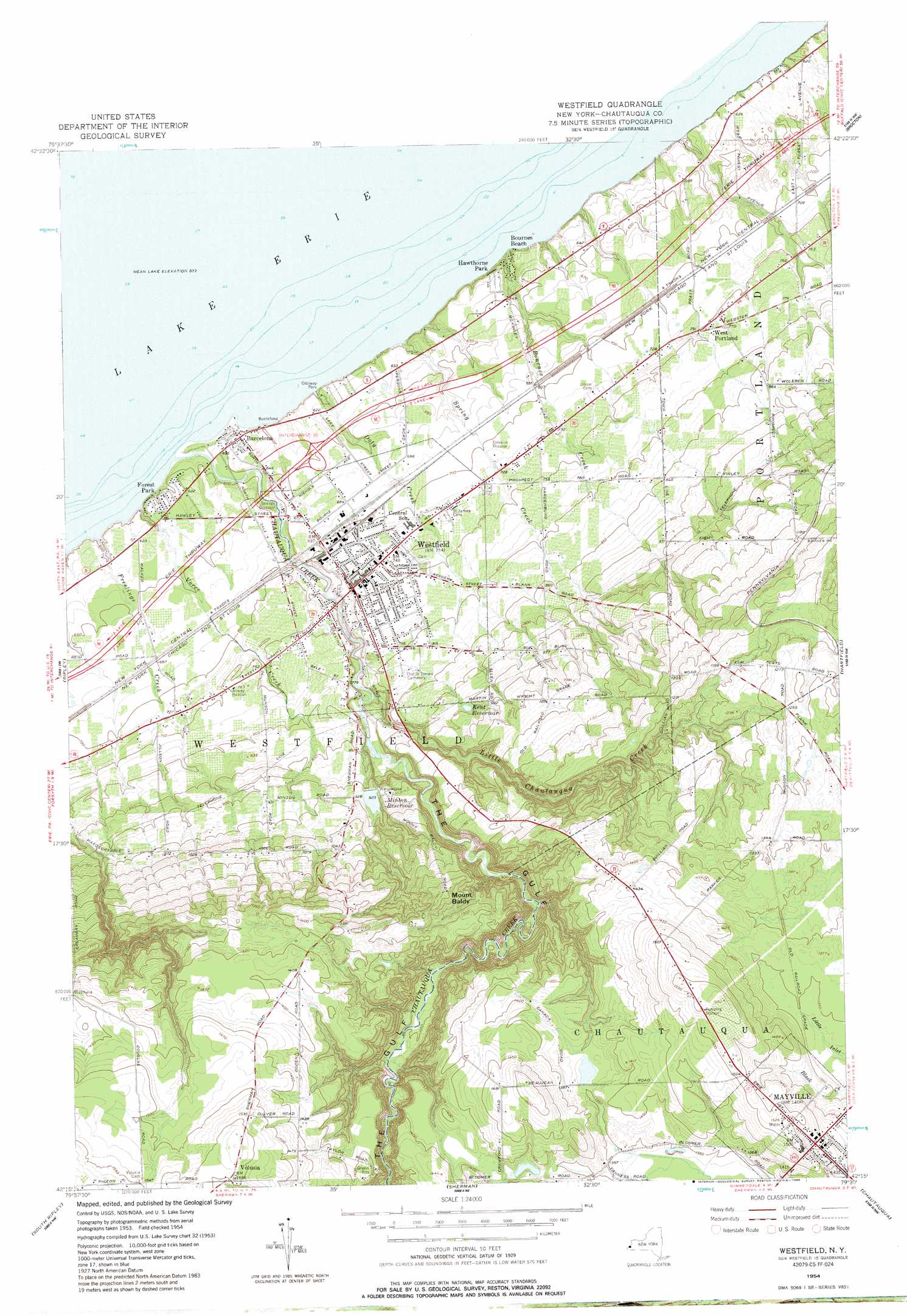
USGS Topo Quad 42079c5 - 1:24,000 scale
| Topo Map Name: | Westfield |
| USGS Topo Quad ID: | 42079c5 |
| Print Size: | ca. 21 1/4" wide x 27" high |
| Southeast Coordinates: | 42.25° N latitude / 79.5° W longitude |
| Map Center Coordinates: | 42.3125° N latitude / 79.5625° W longitude |
| U.S. State: | NY |
| Filename: | o42079c5.jpg |
| Download Map JPG Image: | Westfield topo map 1:24,000 scale |
| Map Type: | Topographic |
| Topo Series: | 7.5´ |
| Map Scale: | 1:24,000 |
| Source of Map Images: | United States Geological Survey (USGS) |
| Alternate Map Versions: |
Westfield NY 1954, updated 1957 Download PDF Buy paper map Westfield NY 1954, updated 1963 Download PDF Buy paper map Westfield NY 1954, updated 1963 Download PDF Buy paper map Westfield NY 1954, updated 1985 Download PDF Buy paper map Westfield NY 1954, updated 1985 Download PDF Buy paper map Westfield NY 2010 Download PDF Buy paper map Westfield NY 2013 Download PDF Buy paper map Westfield NY 2016 Download PDF Buy paper map |
1:24,000 Topo Quads surrounding Westfield
North Of Dunkirk |
||||
Brocton |
Dunkirk |
|||
Ripley |
Westfield |
Hartfield |
Cassadaga |
|
North East |
South Ripley |
Sherman |
Chautauqua |
Ellery Center |
Wattsburg |
Clymer |
North Clymer |
Panama |
Lakewood |
> Back to 42079a1 at 1:100,000 scale
> Back to 42078a1 at 1:250,000 scale
> Back to U.S. Topo Maps home
Westfield topo map: Gazetteer
Westfield: Airports
Camp Vernon Airport elevation 200m 656′Westfield Memorial Hospital Heliport elevation 221m 725′
Westfield: Crossings
Interchange 60 elevation 197m 646′Westfield: Parks
Hawthorne Park elevation 190m 623′Lincoln-Bedell Statue Park elevation 226m 741′
Moore Park elevation 228m 748′
Northlake Recreation Center elevation 204m 669′
Ottoway Park elevation 189m 620′
Westfield: Populated Places
Barcelona elevation 184m 603′Bournes Beach elevation 187m 613′
East Side Trailer Park elevation 220m 721′
Forest Park elevation 189m 620′
Mayville elevation 443m 1453′
Volusia elevation 473m 1551′
West Portland elevation 229m 751′
Westfield elevation 227m 744′
Westfield: Reservoirs
Kent Reservoir elevation 283m 928′Minton Reservoir elevation 277m 908′
Westfield: Streams
Bournes Creek elevation 179m 587′Chautauqua Creek elevation 174m 570′
Doty Creek elevation 184m 603′
Freelings Creek elevation 174m 570′
Little Chautauqua Creek elevation 219m 718′
Spring Creek elevation 186m 610′
Vorce Creek elevation 177m 580′
Westfield: Summits
Mount Baldy elevation 413m 1354′Westfield: Valleys
The Gulf elevation 223m 731′Westfield digital topo map on disk
Buy this Westfield topo map showing relief, roads, GPS coordinates and other geographical features, as a high-resolution digital map file on DVD:
 map DVD")