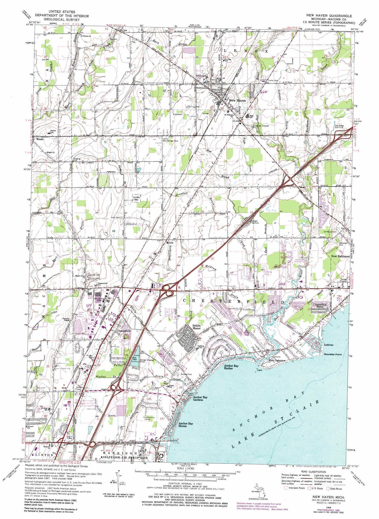
New Haven Topo Map Michigan
To zoom in, hover over the map of New Haven
USGS Topo Quad 42082f7 - 1:24,000 scale
| Topo Map Name: | New Haven |
| USGS Topo Quad ID: | 42082f7 |
| Print Size: | ca. 21 1/4" wide x 27" high |
| Southeast Coordinates: | 42.625° N latitude / 82.75° W longitude |
| Map Center Coordinates: | 42.6875° N latitude / 82.8125° W longitude |
| U.S. State: | MI |
| Filename: | o42082f7.jpg |
| Download Map JPG Image: | New Haven topo map 1:24,000 scale |
| Map Type: | Topographic |
| Topo Series: | 7.5´ |
| Map Scale: | 1:24,000 |
| Source of Map Images: | United States Geological Survey (USGS) |
| Alternate Map Versions: |
New Haven MI 1952, updated 1954 Download PDF Buy paper map New Haven MI 1968, updated 1971 Download PDF Buy paper map New Haven MI 1968, updated 1974 Download PDF Buy paper map New Haven MI 1968, updated 1984 Download PDF Buy paper map New Haven MI 2011 Download PDF Buy paper map New Haven MI 2014 Download PDF Buy paper map New Haven MI 2017 Download PDF Buy paper map |
1:24,000 Topo Quads surrounding New Haven
Almont |
Allenton |
Memphis |
Goodells |
Smiths Creek |
Romeo |
Armada |
Richmond |
Adair |
Rattle Run |
Utica |
Waldenburg |
New Haven |
New Baltimore |
Marine City |
Warren |
Mount Clemens West |
Mount Clemens East |
Saint Clair Flats |
Algonac |
Highland Park |
Grosse Pointe |
> Back to 42082e1 at 1:100,000 scale
> Back to 42082a1 at 1:250,000 scale
> Back to U.S. Topo Maps home
New Haven topo map: Gazetteer
New Haven: Canals
Bowman Ditch elevation 185m 606′New Haven: Capes
Goulette Point elevation 175m 574′New Haven: Lakes
Lake Tranquillity elevation 188m 616′New Haven: Oilfields
Lenox Gas Storage Field elevation 195m 639′New Haven: Parks
Kolping Park elevation 177m 580′New Haven: Populated Places
Anchor Bay Gardens elevation 175m 574′Anchor Bay Harbor elevation 176m 577′
Anchor Bay Shores elevation 176m 577′
Chesterfield elevation 185m 606′
Chesterfield Shores elevation 180m 590′
Lottivue elevation 176m 577′
Meade elevation 192m 629′
Milton elevation 185m 606′
New Haven elevation 191m 626′
Point Lakeview elevation 176m 577′
Sebille Manor elevation 179m 587′
New Haven: Streams
Auvase Creek elevation 175m 574′Bark Drain elevation 192m 629′
Brandenburg Drain elevation 181m 593′
Crandall Drain elevation 180m 590′
East Branch Fish Creek elevation 178m 583′
Fish Creek elevation 176m 577′
Fuller Drain elevation 177m 580′
Gibbons Drain elevation 181m 593′
Harms Drain elevation 177m 580′
Kirkham Drain elevation 179m 587′
Meldrum Drain elevation 176m 577′
Parker Drain elevation 187m 613′
Peltier Drain elevation 176m 577′
Pitts Drain elevation 178m 583′
Ray-Lenox Drain elevation 186m 610′
Salt River elevation 175m 574′
Shook Drain elevation 183m 600′
Stark Drain elevation 185m 606′
Sutherland Oemig Drain elevation 177m 580′
Tucker Jones Drain elevation 176m 577′
Wacker Drain elevation 178m 583′
Warwick Drain elevation 198m 649′
West Branch Fish Creek elevation 184m 603′
New Haven digital topo map on disk
Buy this New Haven topo map showing relief, roads, GPS coordinates and other geographical features, as a high-resolution digital map file on DVD:
 map DVD")