Saint Clair Topo Map Michigan
To zoom in, hover over the map of Saint Clair
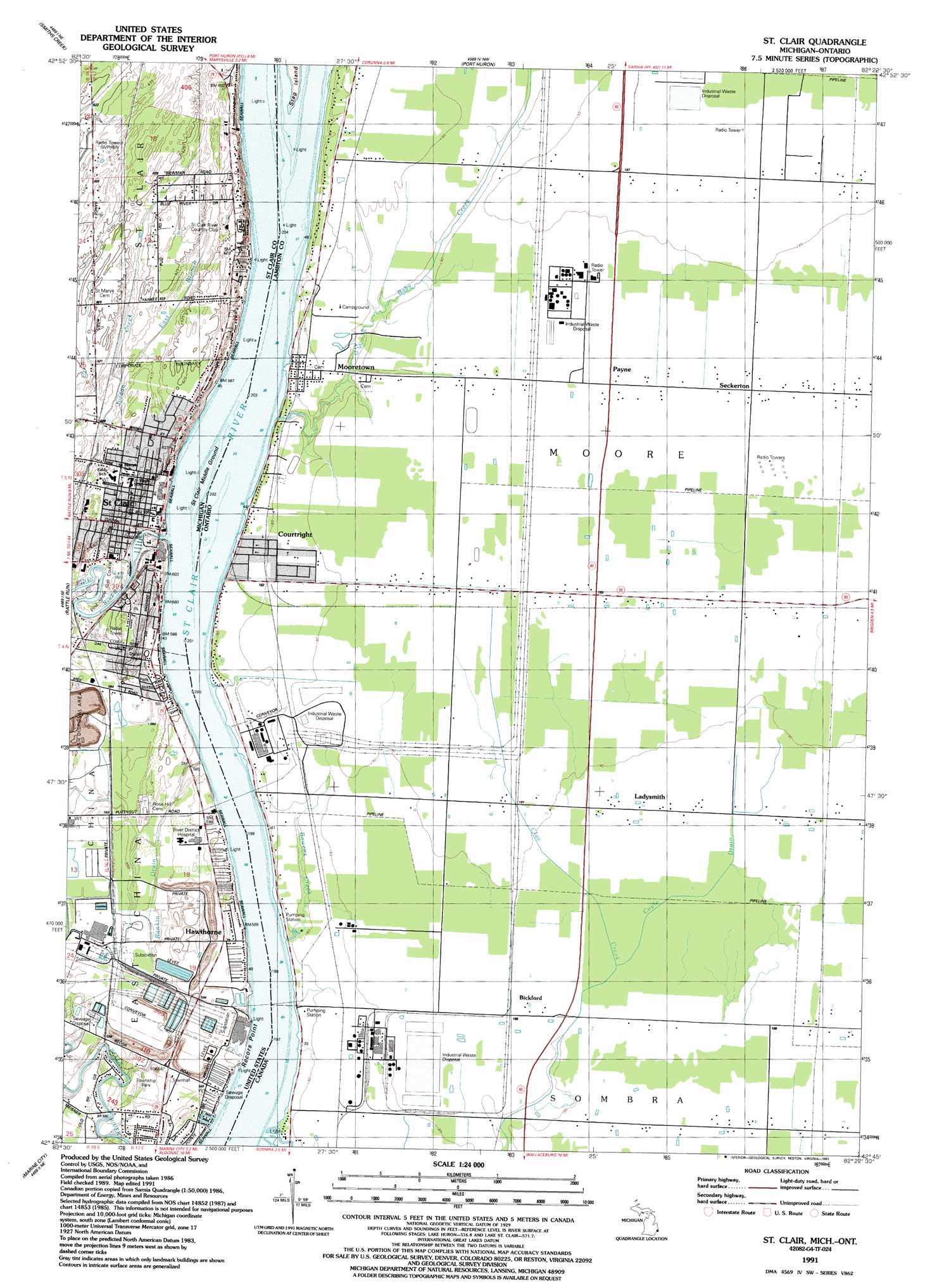
USGS Topo Quad 42082g4 - 1:24,000 scale
| Topo Map Name: | Saint Clair |
| USGS Topo Quad ID: | 42082g4 |
| Print Size: | ca. 21 1/4" wide x 27" high |
| Southeast Coordinates: | 42.75° N latitude / 82.375° W longitude |
| Map Center Coordinates: | 42.8125° N latitude / 82.4375° W longitude |
| U.S. State: | MI |
| Filename: | o42082g4.jpg |
| Download Map JPG Image: | Saint Clair topo map 1:24,000 scale |
| Map Type: | Topographic |
| Topo Series: | 7.5´ |
| Map Scale: | 1:24,000 |
| Source of Map Images: | United States Geological Survey (USGS) |
| Alternate Map Versions: |
St. Clair MI 1939 Download PDF Buy paper map St. Clair MI 1952, updated 1954 Download PDF Buy paper map St. Clair MI 1968, updated 1971 Download PDF Buy paper map St. Clair MI 1968, updated 1974 Download PDF Buy paper map St. Clair MI 1991, updated 1991 Download PDF Buy paper map St. Clair MI 2011 Download PDF Buy paper map St. Clair MI 2014 Download PDF Buy paper map St. Clair MI 2017 Download PDF Buy paper map |
1:24,000 Topo Quads surrounding Saint Clair
Avoca |
Ruby |
Lakeport |
||
Goodells |
Smiths Creek |
Port Huron |
||
Adair |
Rattle Run |
Saint Clair |
||
New Baltimore |
Marine City |
|||
Saint Clair Flats |
Algonac |
> Back to 42082e1 at 1:100,000 scale
> Back to 42082a1 at 1:250,000 scale
> Back to U.S. Topo Maps home
Saint Clair topo map: Gazetteer
Saint Clair: Bars
Saint Clair Middle Ground elevation 175m 574′Saint Clair: Canals
Pointe Drain elevation 177m 580′Saint Clair: Capes
Recors Point elevation 177m 580′Saint Clair: Parks
Diamond Crystal Salt Company Historical Marker elevation 181m 593′East China Fractional District Number Two School Historical Marker elevation 178m 583′
First Baptist Church of Saint Clair Historical Marker elevation 180m 590′
First Congregational Church Historical Marker elevation 180m 590′
Saint Clair Inn Historical Marker elevation 180m 590′
Saint Mary's Church Historical Marker elevation 187m 613′
Saint Mary's Rectory Historical Marker elevation 187m 613′
Township Park elevation 178m 583′
Saint Clair: Populated Places
Hawthorne elevation 180m 590′Rivers Edge a Quiet Community Mobile Home Park elevation 180m 590′
Saint Clair elevation 178m 583′
Saint Clair: Post Offices
Saint Clair Post Office elevation 180m 590′Saint Clair Springs Post Office (historical) elevation 183m 600′
Saint Clair: Streams
East Branch Jordan Creek elevation 184m 603′Pine River elevation 175m 574′
Saint Clair digital topo map on disk
Buy this Saint Clair topo map showing relief, roads, GPS coordinates and other geographical features, as a high-resolution digital map file on DVD:
 map DVD")