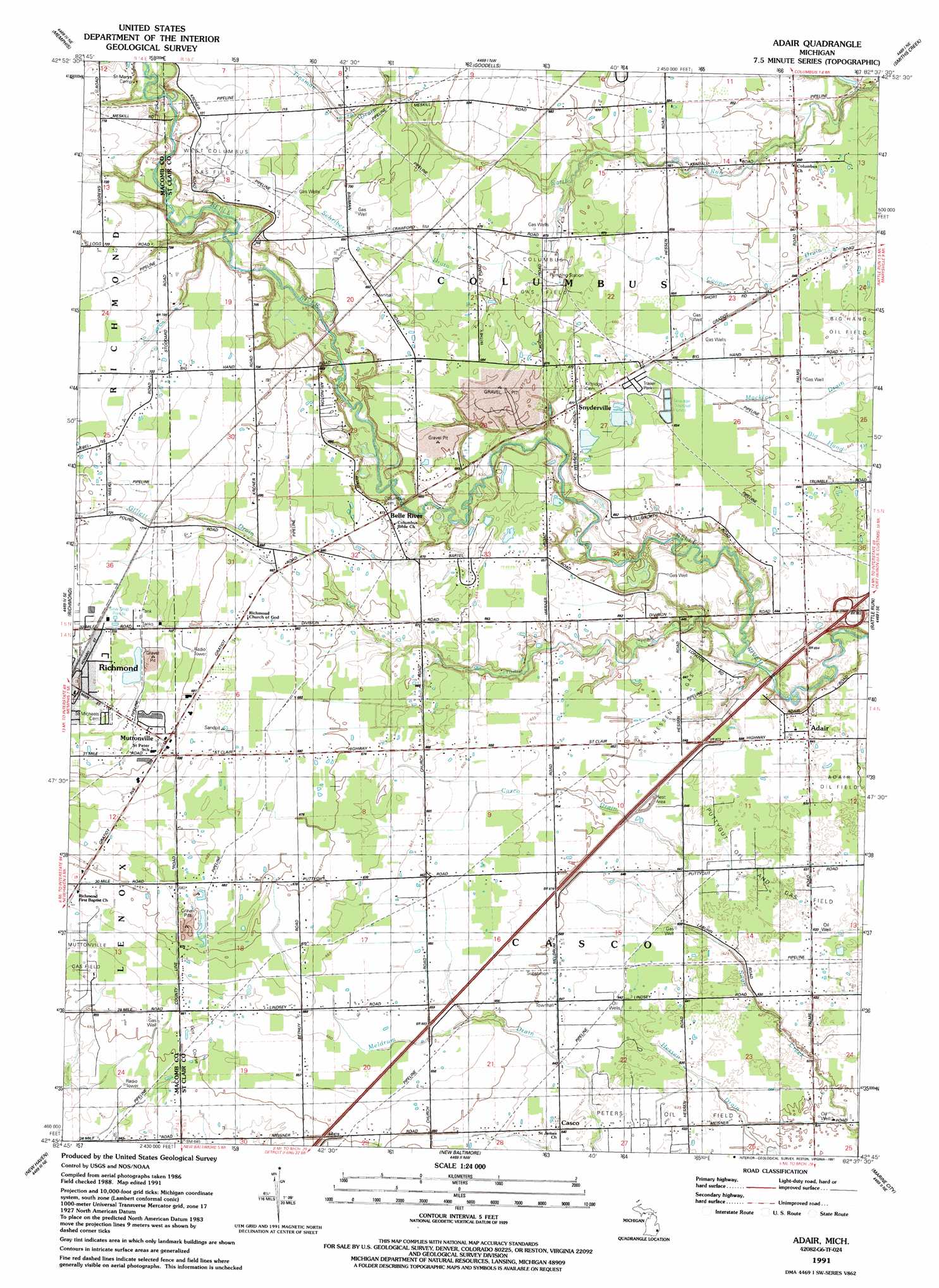
Adair Topo Map Michigan
To zoom in, hover over the map of Adair
USGS Topo Quad 42082g6 - 1:24,000 scale
| Topo Map Name: | Adair |
| USGS Topo Quad ID: | 42082g6 |
| Print Size: | ca. 21 1/4" wide x 27" high |
| Southeast Coordinates: | 42.75° N latitude / 82.625° W longitude |
| Map Center Coordinates: | 42.8125° N latitude / 82.6875° W longitude |
| U.S. State: | MI |
| Filename: | o42082g6.jpg |
| Download Map JPG Image: | Adair topo map 1:24,000 scale |
| Map Type: | Topographic |
| Topo Series: | 7.5´ |
| Map Scale: | 1:24,000 |
| Source of Map Images: | United States Geological Survey (USGS) |
| Alternate Map Versions: |
Adair MI 1939 Download PDF Buy paper map Adair MI 1952, updated 1954 Download PDF Buy paper map Adair MI 1968, updated 1971 Download PDF Buy paper map Adair MI 1968, updated 1974 Download PDF Buy paper map Adair MI 1968, updated 1986 Download PDF Buy paper map Adair MI 1991, updated 1991 Download PDF Buy paper map Adair MI 2011 Download PDF Buy paper map Adair MI 2014 Download PDF Buy paper map Adair MI 2017 Download PDF Buy paper map |
1:24,000 Topo Quads surrounding Adair
Capac |
Brockway |
Avoca |
Ruby |
Lakeport |
Allenton |
Memphis |
Goodells |
Smiths Creek |
Port Huron |
Armada |
Richmond |
Adair |
Rattle Run |
Saint Clair |
Waldenburg |
New Haven |
New Baltimore |
Marine City |
|
Mount Clemens West |
Mount Clemens East |
Saint Clair Flats |
Algonac |
> Back to 42082e1 at 1:100,000 scale
> Back to 42082a1 at 1:250,000 scale
> Back to U.S. Topo Maps home
Adair topo map: Gazetteer
Adair: Airports
Adair Airstrip elevation 196m 643′Robertson Field elevation 198m 649′
Adair: Crossings
Interchange 257 elevation 197m 646′Adair: Oilfields
Big Hand Oil Field elevation 196m 643′Columbus Gas Field elevation 204m 669′
Hessen Oil Field elevation 197m 646′
Muttonville Gas Field elevation 200m 656′
Peters Oil Field elevation 193m 633′
Puttygut Oil and Gas Field elevation 195m 639′
West Columbus Gas Field elevation 219m 718′
Adair: Parks
Belle River Park elevation 193m 633′Adair: Populated Places
Adair elevation 195m 639′Belle River elevation 204m 669′
Casco elevation 195m 639′
Muttonville elevation 213m 698′
Snyderville elevation 206m 675′
Adair: Post Offices
Adair Post Office (historical) elevation 195m 639′Casco Post Office (historical) elevation 195m 639′
Adair: Streams
Dawson Drain elevation 191m 626′Gillett Drain elevation 203m 666′
Jerome Creek elevation 187m 613′
Adair digital topo map on disk
Buy this Adair topo map showing relief, roads, GPS coordinates and other geographical features, as a high-resolution digital map file on DVD:
 map DVD")