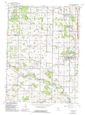
Carleton Topo Map Michigan
To zoom in, hover over the map of Carleton
USGS Topo Quad 42083a4 - 1:24,000 scale
| Topo Map Name: | Carleton |
| USGS Topo Quad ID: | 42083a4 |
| Print Size: | ca. 21 1/4" wide x 27" high |
| Southeast Coordinates: | 42° N latitude / 83.375° W longitude |
| Map Center Coordinates: | 42.0625° N latitude / 83.4375° W longitude |
| U.S. State: | MI |
| Filename: | o42083a4.jpg |
| Download Map JPG Image: | Carleton topo map 1:24,000 scale |
| Map Type: | Topographic |
| Topo Series: | 7.5´ |
| Map Scale: | 1:24,000 |
| Source of Map Images: | United States Geological Survey (USGS) |
| Alternate Map Versions: |
Carleton MI 1942 Download PDF Buy paper map Carleton MI 1952, updated 1954 Download PDF Buy paper map Carleton MI 1967, updated 1969 Download PDF Buy paper map Carleton MI 1967, updated 1991 Download PDF Buy paper map Carleton MI 1967, updated 1991 Download PDF Buy paper map Carleton MI 2011 Download PDF Buy paper map Carleton MI 2014 Download PDF Buy paper map Carleton MI 2017 Download PDF Buy paper map |
1:24,000 Topo Quads surrounding Carleton
> Back to 42083a1 at 1:100,000 scale
> Back to 42082a1 at 1:250,000 scale
> Back to U.S. Topo Maps home
Carleton topo map: Gazetteer
Carleton: Airports
Wickenheiser Airport elevation 186m 610′Carleton: Parks
Ash Carleton Park elevation 189m 620′Exeter Township Hall Historical Marker elevation 192m 629′
Saint Patrick Church Historical Marker elevation 187m 613′
Carleton: Populated Places
Carleton elevation 188m 616′Carleton Mobile Home Park elevation 187m 613′
Exeter (historical) elevation 193m 633′
Grafton elevation 186m 610′
Scofield elevation 192m 629′
Waltz elevation 189m 620′
Willow elevation 191m 626′
Yorkshire Manor Mobile Home Park elevation 187m 613′
Carleton: Post Offices
Athlone Post Office (historical) elevation 187m 613′Carleton Post Office elevation 186m 610′
Exeter Post Office (historical) elevation 193m 633′
Grafton Post Office (historical) elevation 186m 610′
Scofield Post Office (historical) elevation 192m 629′
Carleton: Streams
Alfen Drain elevation 185m 606′Batway Drain elevation 189m 620′
Beaver Swale Drain elevation 187m 613′
Boes Drain elevation 190m 623′
Burgess Drain elevation 186m 610′
Burnap Drain elevation 191m 626′
Burns Drain elevation 187m 613′
Clark Morey Drain elevation 191m 626′
Cole Drain elevation 189m 620′
Coyle Drain elevation 185m 606′
Cranberry Drain elevation 190m 623′
Davis Drain elevation 190m 623′
Disbrow Drain elevation 187m 613′
Dunn Drain elevation 190m 623′
Emmons Drain elevation 184m 603′
Green Drain elevation 190m 623′
Hamilton Drain elevation 183m 600′
Helser Drain elevation 191m 626′
Horen Drain elevation 189m 620′
John Hoffman Drain elevation 189m 620′
Kelly Drain elevation 188m 616′
Larkin Drain elevation 186m 610′
Little Stony Creek elevation 189m 620′
Lords Drain elevation 192m 629′
Martin Drain elevation 188m 616′
Mosquito Drain elevation 184m 603′
Murphy Drain elevation 188m 616′
Robert Drain elevation 183m 600′
Ross Drain elevation 186m 610′
Schwab Drain elevation 189m 620′
Spaulding Drain elevation 187m 613′
Streit Drain elevation 184m 603′
Teall Drain elevation 190m 623′
Townline Drain elevation 189m 620′
Winters Drain elevation 200m 656′
Zink and Nolan Drain elevation 189m 620′
Carleton digital topo map on disk
Buy this Carleton topo map showing relief, roads, GPS coordinates and other geographical features, as a high-resolution digital map file on DVD:


