Royal Oak Topo Map Michigan
To zoom in, hover over the map of Royal Oak
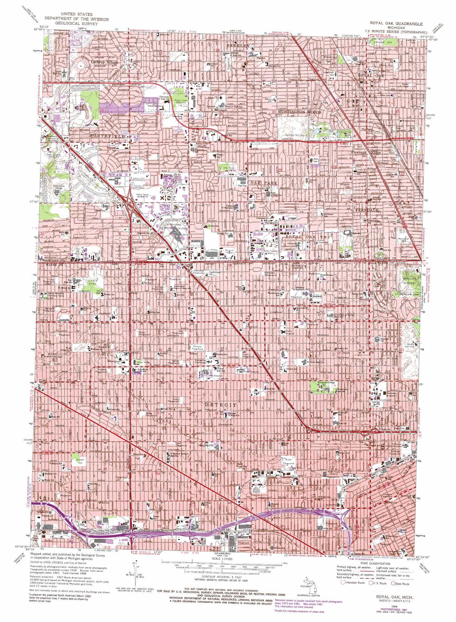
USGS Topo Quad 42083d2 - 1:24,000 scale
| Topo Map Name: | Royal Oak |
| USGS Topo Quad ID: | 42083d2 |
| Print Size: | ca. 21 1/4" wide x 27" high |
| Southeast Coordinates: | 42.375° N latitude / 83.125° W longitude |
| Map Center Coordinates: | 42.4375° N latitude / 83.1875° W longitude |
| U.S. State: | MI |
| Filename: | o42083d2.jpg |
| Download Map JPG Image: | Royal Oak topo map 1:24,000 scale |
| Map Type: | Topographic |
| Topo Series: | 7.5´ |
| Map Scale: | 1:24,000 |
| Source of Map Images: | United States Geological Survey (USGS) |
| Alternate Map Versions: |
Royal Oak MI 1941 Download PDF Buy paper map Royal Oak MI 1952, updated 1954 Download PDF Buy paper map Royal Oak MI 1968, updated 1971 Download PDF Buy paper map Royal Oak MI 1968, updated 1974 Download PDF Buy paper map Royal Oak MI 1968, updated 1981 Download PDF Buy paper map Royal Oak MI 1968, updated 1981 Download PDF Buy paper map Royal Oak MI 1996, updated 2000 Download PDF Buy paper map Royal Oak MI 2011 Download PDF Buy paper map Royal Oak MI 2014 Download PDF Buy paper map Royal Oak MI 2017 Download PDF Buy paper map |
1:24,000 Topo Quads surrounding Royal Oak
Clarkston |
Pontiac North |
Rochester |
Utica |
Waldenburg |
Walled Lake |
Pontiac South |
Birmingham |
Warren |
Mount Clemens West |
Northville |
Redford |
Royal Oak |
Highland Park |
Grosse Pointe |
Wayne |
Inkster |
Dearborn |
Detroit |
Belle Isle |
Belleville |
Flat Rock Ne |
Wyandotte |
> Back to 42083a1 at 1:100,000 scale
> Back to 42082a1 at 1:250,000 scale
> Back to U.S. Topo Maps home
Royal Oak topo map: Gazetteer
Royal Oak: Airports
Bendix Heliport elevation 202m 662′TV2 Heliport elevation 205m 672′
Royal Oak: Parks
Arthur Playground elevation 201m 659′Bale Playground elevation 202m 662′
Butzel Playground elevation 199m 652′
Civic Center Park elevation 220m 721′
Comstock Playground elevation 203m 666′
Cook Playground elevation 197m 646′
Detroit Zoological Park elevation 201m 659′
Diack Playground elevation 202m 662′
Dondero Park elevation 195m 639′
Fields Playground elevation 200m 656′
Gorham Playground elevation 203m 666′
Hackett Playground elevation 196m 643′
Harding Park elevation 195m 639′
Hardstein Playground elevation 201m 659′
Hyde Park elevation 200m 656′
Kelley Playground elevation 197m 646′
Lawson Park elevation 197m 646′
Mallett Playground elevation 190m 623′
Marks Park elevation 195m 639′
Marx Playground elevation 198m 649′
Maxwell Park elevation 201m 659′
Milan Playground elevation 195m 639′
O'Hair Park elevation 201m 659′
O'Shea Playground elevation 189m 620′
Oxford Park elevation 203m 666′
Peterson Playground elevation 201m 659′
Reid Park elevation 196m 643′
Roosevelt Park elevation 204m 669′
Salsinger Playground elevation 196m 643′
Sawyer Playground elevation 198m 649′
Sherwood Park elevation 200m 656′
Southfield Park elevation 215m 705′
Stoepel Park elevation 191m 626′
Tuttle Playground elevation 197m 646′
Varrier Playground elevation 201m 659′
Votrobeck Playground elevation 195m 639′
Wendtland Park elevation 198m 649′
Whittier Park elevation 197m 646′
Woods Park elevation 195m 639′
Zussman Playground elevation 196m 643′
Royal Oak: Populated Places
Ferndale elevation 197m 646′Huntington Woods elevation 202m 662′
Lathrup Village elevation 215m 705′
Oak elevation 189m 620′
Oak Park elevation 203m 666′
Pleasant Ridge elevation 198m 649′
Royal Oak elevation 202m 662′
Southfield elevation 208m 682′
Royal Oak digital topo map on disk
Buy this Royal Oak topo map showing relief, roads, GPS coordinates and other geographical features, as a high-resolution digital map file on DVD:
 map DVD")