Clarkston Topo Map Michigan
To zoom in, hover over the map of Clarkston
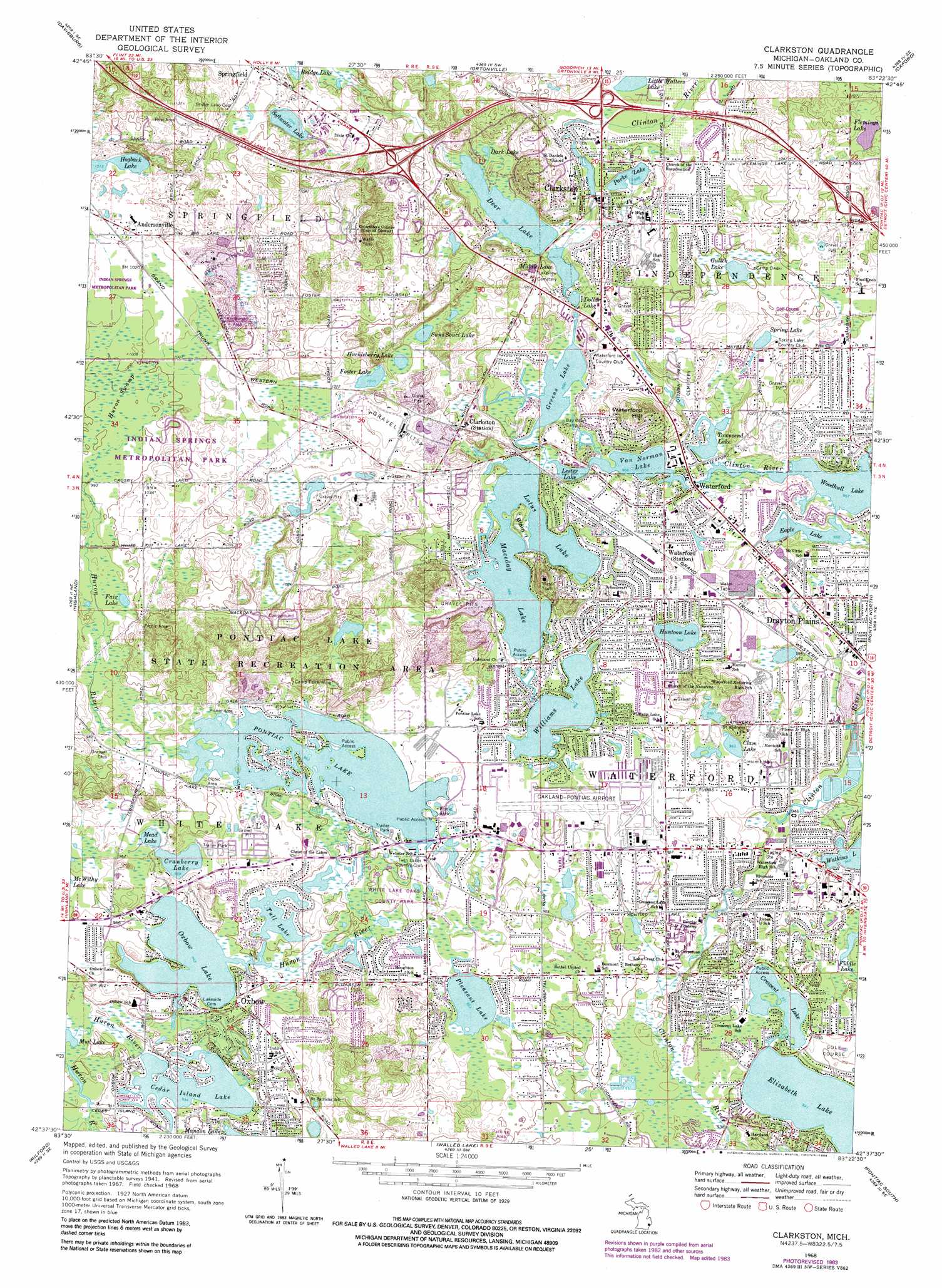
USGS Topo Quad 42083f4 - 1:24,000 scale
| Topo Map Name: | Clarkston |
| USGS Topo Quad ID: | 42083f4 |
| Print Size: | ca. 21 1/4" wide x 27" high |
| Southeast Coordinates: | 42.625° N latitude / 83.375° W longitude |
| Map Center Coordinates: | 42.6875° N latitude / 83.4375° W longitude |
| U.S. State: | MI |
| Filename: | o42083f4.jpg |
| Download Map JPG Image: | Clarkston topo map 1:24,000 scale |
| Map Type: | Topographic |
| Topo Series: | 7.5´ |
| Map Scale: | 1:24,000 |
| Source of Map Images: | United States Geological Survey (USGS) |
| Alternate Map Versions: |
Clarkston MI 1943 Download PDF Buy paper map Clarkston MI 1952, updated 1954 Download PDF Buy paper map Clarkston MI 1968, updated 1971 Download PDF Buy paper map Clarkston MI 1968, updated 1974 Download PDF Buy paper map Clarkston MI 1968, updated 1984 Download PDF Buy paper map Clarkston MI 1968, updated 1984 Download PDF Buy paper map Clarkston MI 2011 Download PDF Buy paper map Clarkston MI 2014 Download PDF Buy paper map Clarkston MI 2017 Download PDF Buy paper map |
1:24,000 Topo Quads surrounding Clarkston
Flint South |
Goodrich |
Hadley |
Metamora |
Thornville |
Fenton |
Davisburg |
Ortonville |
Oxford |
Lake Orion |
West Highland |
Highland |
Clarkston |
Pontiac North |
Rochester |
Kent Lake |
Milford |
Walled Lake |
Pontiac South |
Birmingham |
South Lyon |
Salem |
Northville |
Redford |
Royal Oak |
> Back to 42083e1 at 1:100,000 scale
> Back to 42082a1 at 1:250,000 scale
> Back to U.S. Topo Maps home
Clarkston topo map: Gazetteer
Clarkston: Airports
Oakland-Pontiac Airport elevation 296m 971′Wagners Landing Heliport elevation 296m 971′
Clarkston: Islands
Blain Island elevation 296m 971′Clarkston: Lakes
Cedar Island Lake elevation 285m 935′Clam Lake elevation 293m 961′
Cranberry Lake elevation 292m 958′
Crescent Lake elevation 284m 931′
Dark Lake elevation 295m 967′
Deer Lake elevation 295m 967′
Dollar Lake elevation 295m 967′
Eagle Lake elevation 292m 958′
Elizabeth Lake elevation 284m 931′
Fair Lake elevation 301m 987′
Fiddle Lake elevation 286m 938′
Flemings Lake elevation 325m 1066′
Foster Lake elevation 308m 1010′
Foxdale Lake elevation 292m 958′
Greens Lake elevation 294m 964′
Gulick Lake elevation 304m 997′
Hogback Lake elevation 309m 1013′
Huckleberry Lake elevation 313m 1026′
Huntoon Lake elevation 294m 964′
Lester Lake elevation 294m 964′
Little Walters Lake elevation 309m 1013′
Lotus Lake elevation 294m 964′
Maceday Lake elevation 294m 964′
Mead Lake elevation 292m 958′
Middle Lake elevation 295m 967′
Mud Lake elevation 286m 938′
Oxbow Lake elevation 287m 941′
Parke Lake elevation 301m 987′
Pleasant Lake elevation 290m 951′
Pontiac Lake elevation 293m 961′
Sans Souci Lake elevation 313m 1026′
Softwater Lake elevation 306m 1003′
Spring Lake elevation 298m 977′
Townsend Lake elevation 292m 958′
Tull Lake elevation 290m 951′
Van Norman Lake elevation 294m 964′
Williams Lake elevation 294m 964′
Woodhull Lake elevation 292m 958′
Clarkston: Parks
Pontiac Lake State Recreation Area elevation 300m 984′Clarkston: Populated Places
Andersonville elevation 311m 1020′Clarkston elevation 306m 1003′
Drayton Plains elevation 298m 977′
Oxbow elevation 289m 948′
Springfield elevation 313m 1026′
Waterford elevation 294m 964′
Clarkston: Summits
Waterford Hill elevation 349m 1145′Clarkston: Swamps
Huron Swamp elevation 304m 997′Clarkston digital topo map on disk
Buy this Clarkston topo map showing relief, roads, GPS coordinates and other geographical features, as a high-resolution digital map file on DVD:
 map DVD")