Chelsea Topo Map Michigan
To zoom in, hover over the map of Chelsea
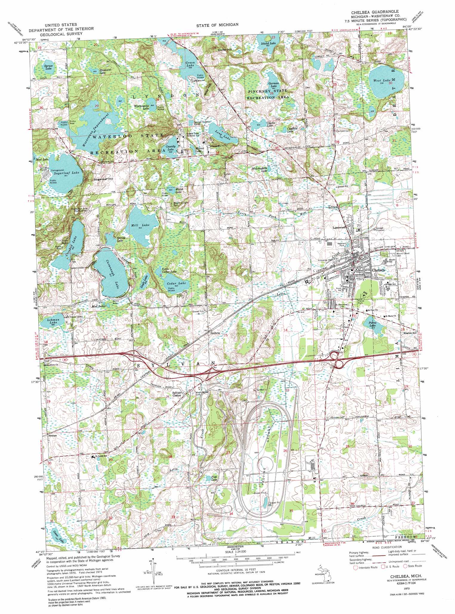
USGS Topo Quad 42084c1 - 1:24,000 scale
| Topo Map Name: | Chelsea |
| USGS Topo Quad ID: | 42084c1 |
| Print Size: | ca. 21 1/4" wide x 27" high |
| Southeast Coordinates: | 42.25° N latitude / 84° W longitude |
| Map Center Coordinates: | 42.3125° N latitude / 84.0625° W longitude |
| U.S. State: | MI |
| Filename: | o42084c1.jpg |
| Download Map JPG Image: | Chelsea topo map 1:24,000 scale |
| Map Type: | Topographic |
| Topo Series: | 7.5´ |
| Map Scale: | 1:24,000 |
| Source of Map Images: | United States Geological Survey (USGS) |
| Alternate Map Versions: |
Chelsea MI 1973, updated 1977 Download PDF Buy paper map Chelsea MI 1973, updated 1989 Download PDF Buy paper map Chelsea MI 2011 Download PDF Buy paper map Chelsea MI 2014 Download PDF Buy paper map Chelsea MI 2017 Download PDF Buy paper map |
1:24,000 Topo Quads surrounding Chelsea
Dansville |
Millville |
Parkers Corners |
Howell |
Brighton |
Pleasant Lake |
Stockbridge |
Gregory |
Pinckney |
Hamburg |
Gilletts Lake |
Grass Lake |
Chelsea |
Dexter |
Ann Arbor West |
Michigan Center |
Norvell |
Manchester |
Bridgewater |
Saline |
Cement City |
Onsted |
Tipton |
Tecumseh North |
Macon |
> Back to 42084a1 at 1:100,000 scale
> Back to 42084a1 at 1:250,000 scale
> Back to U.S. Topo Maps home
Chelsea topo map: Gazetteer
Chelsea: Airports
Winters Field elevation 312m 1023′Chelsea: Lakes
Canfield Lake elevation 284m 931′Cassidy Lake elevation 294m 964′
Cavanaugh Lake elevation 297m 974′
Cedar Lake elevation 293m 961′
Clarks Lake elevation 284m 931′
Crooked Lake elevation 300m 984′
Doyle Lake elevation 294m 964′
Fisk Lake elevation 293m 961′
Goose Lake elevation 307m 1007′
Gorman Lake elevation 294m 964′
Green Lake elevation 291m 954′
Hankard Lake elevation 291m 954′
Island Lake elevation 290m 951′
Lehman Lake elevation 301m 987′
Little Cedar Lake elevation 294m 964′
Long Lake elevation 288m 944′
McLaughlin Lake elevation 283m 928′
Mill Lake elevation 294m 964′
Mirror Lake elevation 292m 958′
Mud Lakes elevation 295m 967′
Pierce Lake elevation 278m 912′
Spring Lake elevation 297m 974′
Spruce Lake elevation 292m 958′
Sugarloaf Lake elevation 291m 954′
Walsh Lake elevation 294m 964′
West Lake elevation 285m 935′
Winnewana Lake elevation 294m 964′
Chelsea: Parks
Pierce Park elevation 283m 928′Chelsea: Populated Places
Chelsea elevation 285m 935′Guthrie elevation 290m 951′
Lanewood elevation 277m 908′
Notten elevation 308m 1010′
Sylvan Center elevation 290m 951′
Chelsea: Reservoirs
Winnewana Impoundment elevation 292m 958′Chelsea: Streams
Letts Creek elevation 271m 889′Chelsea: Summits
Riley Hill elevation 315m 1033′Stofer Hill elevation 324m 1062′
Sugarloaf Hill elevation 336m 1102′
Chelsea digital topo map on disk
Buy this Chelsea topo map showing relief, roads, GPS coordinates and other geographical features, as a high-resolution digital map file on DVD:
Northern Illinois, Northern Indiana & Southwestern Michigan
Buy digital topo maps: Northern Illinois, Northern Indiana & Southwestern Michigan