Springport Topo Map Michigan
To zoom in, hover over the map of Springport
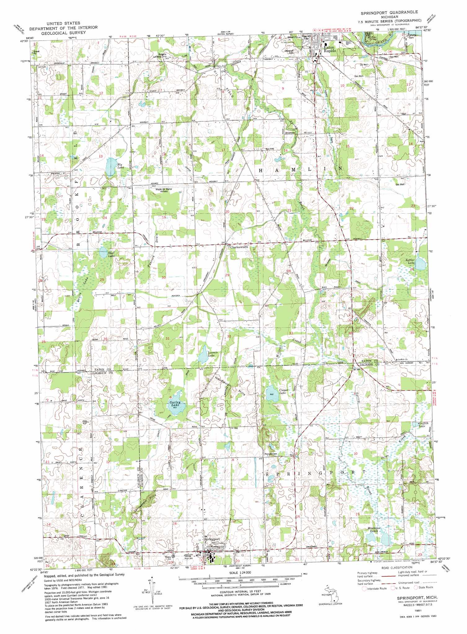
USGS Topo Quad 42084d6 - 1:24,000 scale
| Topo Map Name: | Springport |
| USGS Topo Quad ID: | 42084d6 |
| Print Size: | ca. 21 1/4" wide x 27" high |
| Southeast Coordinates: | 42.375° N latitude / 84.625° W longitude |
| Map Center Coordinates: | 42.4375° N latitude / 84.6875° W longitude |
| U.S. State: | MI |
| Filename: | o42084d6.jpg |
| Download Map JPG Image: | Springport topo map 1:24,000 scale |
| Map Type: | Topographic |
| Topo Series: | 7.5´ |
| Map Scale: | 1:24,000 |
| Source of Map Images: | United States Geological Survey (USGS) |
| Alternate Map Versions: |
Springport MI 1981, updated 1981 Download PDF Buy paper map Springport MI 2011 Download PDF Buy paper map Springport MI 2014 Download PDF Buy paper map Springport MI 2017 Download PDF Buy paper map |
1:24,000 Topo Quads surrounding Springport
Hoytville |
Needmore |
Dimondale |
Lansing South |
East Lansing |
Chester |
Charlotte |
Eaton Rapids |
Aurelius |
Mason |
Olivet |
Duck Lake |
Springport |
Onondaga |
Leslie |
Marshall |
Northwest Albion |
Northeast Albion |
Parma |
Jackson North |
Lyon Lake |
Southwest Albion |
Southeast Albion |
Spring Arbor |
Jackson South |
> Back to 42084a1 at 1:100,000 scale
> Back to 42084a1 at 1:250,000 scale
> Back to U.S. Topo Maps home
Springport topo map: Gazetteer
Springport: Airports
Burgess Landing Strip elevation 275m 902′Maple Air Manor Airfield elevation 286m 938′
Springport: Canals
Carter Drain elevation 280m 918′Gurley Lake Drain elevation 281m 921′
Hobart Drain elevation 270m 885′
McGivrd Drain elevation 283m 928′
Peacock Drain elevation 283m 928′
Shiner Drain elevation 275m 902′
Springport: Lakes
Bly Lake elevation 281m 921′Cooper Lake elevation 281m 921′
Devils Lake elevation 282m 925′
Griffith Lake elevation 283m 928′
Gurley Lake elevation 281m 921′
Kettler Lake elevation 284m 931′
Loomis Lake elevation 281m 921′
Montague Lakes elevation 281m 921′
Steel Lake elevation 281m 921′
Springport: Parks
Hamlin District Number Fifteen School Historical Marker elevation 287m 941′Springport: Populated Places
Charlesworth elevation 280m 918′Springport elevation 305m 1000′
Springport: Post Offices
Charlesworth Post Office (historical) elevation 280m 918′Spicerville Post Office (historical) elevation 272m 892′
Springport: Streams
Otter Creek elevation 280m 918′Willow Creek elevation 279m 915′
Springport: Summits
Holibaugh Hills elevation 296m 971′Jerusalem Hills elevation 289m 948′
Springport digital topo map on disk
Buy this Springport topo map showing relief, roads, GPS coordinates and other geographical features, as a high-resolution digital map file on DVD:
Northern Illinois, Northern Indiana & Southwestern Michigan
Buy digital topo maps: Northern Illinois, Northern Indiana & Southwestern Michigan