Olivet Topo Map Michigan
To zoom in, hover over the map of Olivet
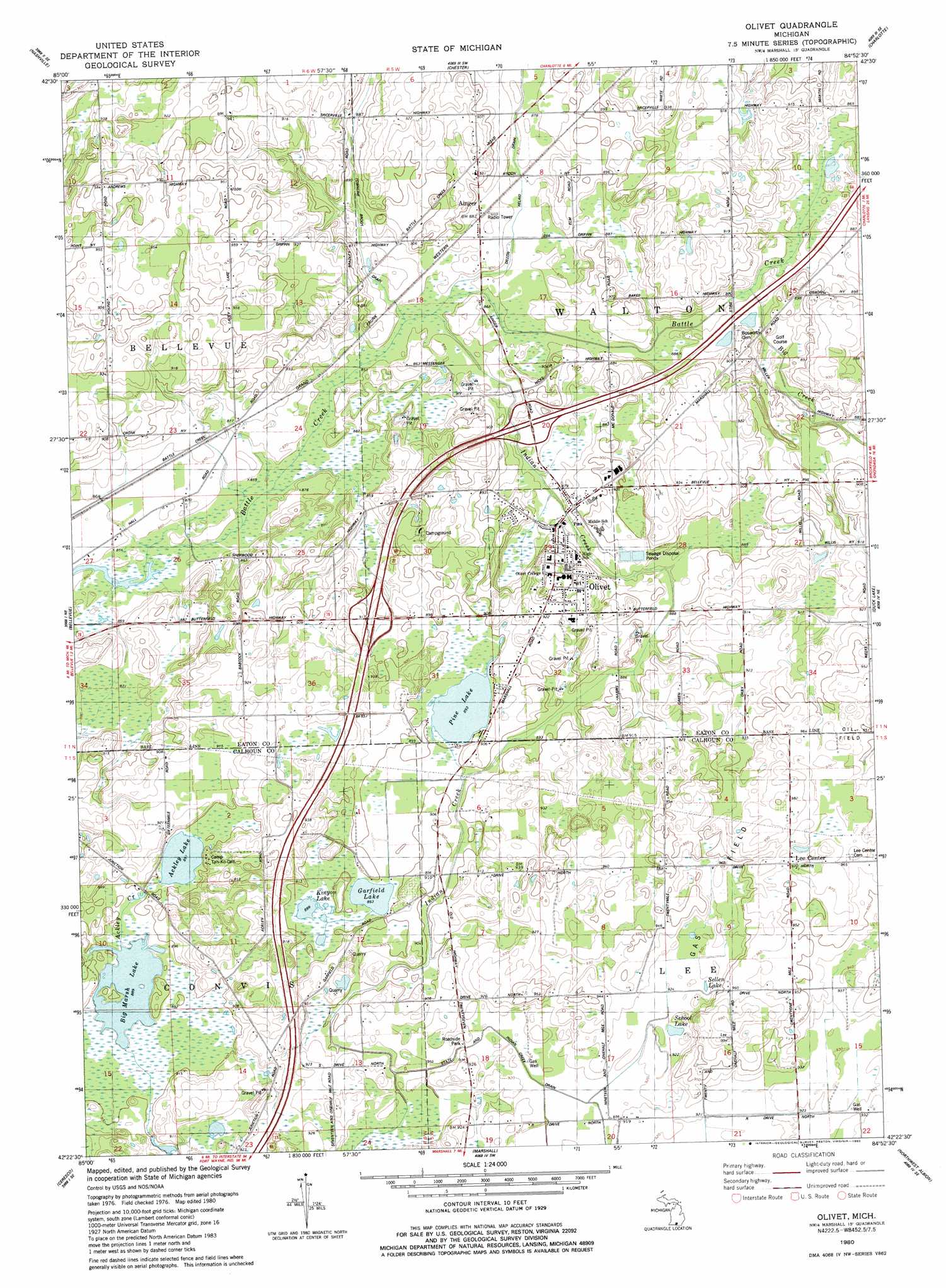
USGS Topo Quad 42084d8 - 1:24,000 scale
| Topo Map Name: | Olivet |
| USGS Topo Quad ID: | 42084d8 |
| Print Size: | ca. 21 1/4" wide x 27" high |
| Southeast Coordinates: | 42.375° N latitude / 84.875° W longitude |
| Map Center Coordinates: | 42.4375° N latitude / 84.9375° W longitude |
| U.S. State: | MI |
| Filename: | o42084d8.jpg |
| Download Map JPG Image: | Olivet topo map 1:24,000 scale |
| Map Type: | Topographic |
| Topo Series: | 7.5´ |
| Map Scale: | 1:24,000 |
| Source of Map Images: | United States Geological Survey (USGS) |
| Alternate Map Versions: |
Olivet MI 1980, updated 1980 Download PDF Buy paper map Olivet MI 2011 Download PDF Buy paper map Olivet MI 2014 Download PDF Buy paper map Olivet MI 2017 Download PDF Buy paper map |
1:24,000 Topo Quads surrounding Olivet
Woodland |
Saubee Lake |
Hoytville |
Needmore |
Dimondale |
Maple Grove |
Nashville |
Chester |
Charlotte |
Eaton Rapids |
Bedford |
Bellevue |
Olivet |
Duck Lake |
Springport |
Battle Creek |
Ceresco |
Marshall |
Northwest Albion |
Northeast Albion |
East Leroy |
Ellis Corners |
Lyon Lake |
Southwest Albion |
Southeast Albion |
> Back to 42084a1 at 1:100,000 scale
> Back to 42084a1 at 1:250,000 scale
> Back to U.S. Topo Maps home
Olivet topo map: Gazetteer
Olivet: Canals
Dillon Relaid Drain elevation 267m 875′Olivet: Crossings
Interchange 48 elevation 272m 892′Interchange 51 elevation 272m 892′
Olivet: Lakes
Ackley Lake elevation 272m 892′Big Marsh Lake elevation 271m 889′
Garfield Lake elevation 272m 892′
Kinyon Lake elevation 272m 892′
Pine Lake elevation 273m 895′
School Lake elevation 282m 925′
Sellen Lake elevation 283m 928′
Olivet: Parks
First Congregational Church Historical Marker elevation 282m 925′Olivet College Historical Marker elevation 285m 935′
Olivet: Populated Places
Ainger elevation 268m 879′Lee Center elevation 296m 971′
Olivet elevation 289m 948′
Olivet: Post Offices
Ainger Post Office (historical) elevation 268m 879′Olivet Post Office elevation 269m 882′
Olivet: Streams
Big Creek elevation 264m 866′Indian Creek elevation 260m 853′
Olivet digital topo map on disk
Buy this Olivet topo map showing relief, roads, GPS coordinates and other geographical features, as a high-resolution digital map file on DVD:
Northern Illinois, Northern Indiana & Southwestern Michigan
Buy digital topo maps: Northern Illinois, Northern Indiana & Southwestern Michigan