Charlotte Topo Map Michigan
To zoom in, hover over the map of Charlotte
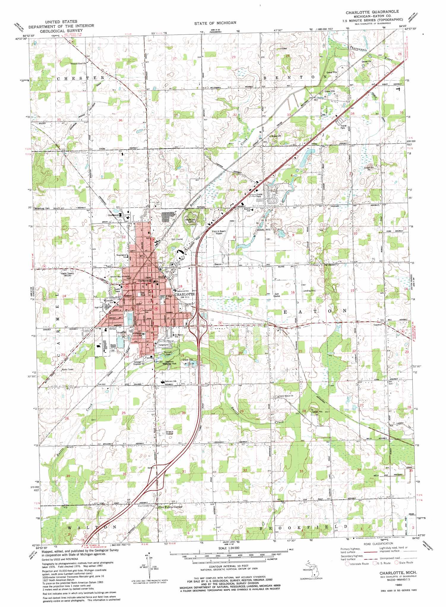
USGS Topo Quad 42084e7 - 1:24,000 scale
| Topo Map Name: | Charlotte |
| USGS Topo Quad ID: | 42084e7 |
| Print Size: | ca. 21 1/4" wide x 27" high |
| Southeast Coordinates: | 42.5° N latitude / 84.75° W longitude |
| Map Center Coordinates: | 42.5625° N latitude / 84.8125° W longitude |
| U.S. State: | MI |
| Filename: | o42084e7.jpg |
| Download Map JPG Image: | Charlotte topo map 1:24,000 scale |
| Map Type: | Topographic |
| Topo Series: | 7.5´ |
| Map Scale: | 1:24,000 |
| Source of Map Images: | United States Geological Survey (USGS) |
| Alternate Map Versions: |
Charlotte MI 1980, updated 1981 Download PDF Buy paper map Charlotte MI 2011 Download PDF Buy paper map Charlotte MI 2014 Download PDF Buy paper map Charlotte MI 2017 Download PDF Buy paper map |
1:24,000 Topo Quads surrounding Charlotte
Woodbury |
Portland South |
Eagle |
Wacousta |
Lansing North |
Saubee Lake |
Hoytville |
Needmore |
Dimondale |
Lansing South |
Nashville |
Chester |
Charlotte |
Eaton Rapids |
Aurelius |
Bellevue |
Olivet |
Duck Lake |
Springport |
Onondaga |
Ceresco |
Marshall |
Northwest Albion |
Northeast Albion |
Parma |
> Back to 42084e1 at 1:100,000 scale
> Back to 42084a1 at 1:250,000 scale
> Back to U.S. Topo Maps home
Charlotte topo map: Gazetteer
Charlotte: Airports
Crippen Field elevation 280m 918′Fitch H Beach Airport elevation 268m 879′
Charlotte: Canals
Densmore Perkins Fish Creek Drain elevation 271m 889′Charlotte: Crossings
Interchange 57 elevation 285m 935′Interchange 60 elevation 276m 905′
Interchange 61 elevation 268m 879′
Charlotte: Parks
1845 Eaton County Courthouse Historical Marker elevation 273m 895′Alliance Lake Softball Park elevation 262m 859′
Bennett Park elevation 272m 892′
Center Eaton United Methodist Church Historical Marker elevation 275m 902′
Dean Park elevation 280m 918′
Eaton County Courthouse Square Historical Marker elevation 277m 908′
Eaton County Historical Marker elevation 277m 908′
First Congregational Church of Charlotte Historical Marker elevation 277m 908′
Joseph and Mary Hall House Historical Marker elevation 278m 912′
Lincoln Park elevation 270m 885′
Oak Park elevation 276m 905′
Southridge Park elevation 278m 912′
Veterans Memorial Park elevation 271m 889′
Charlotte: Populated Places
Charlotte elevation 277m 908′Five Points Corner elevation 286m 938′
Hi-Way Mobile Haven elevation 266m 872′
Lawrence Manor Mobile Home Park elevation 281m 921′
Maple Knoll Mobile Home Park elevation 283m 928′
Meadows Mobile Home Park elevation 284m 931′
Charlotte: Post Offices
Charlotte Post Office elevation 276m 905′Charlotte: Streams
Butternut Creek elevation 259m 849′Charlotte digital topo map on disk
Buy this Charlotte topo map showing relief, roads, GPS coordinates and other geographical features, as a high-resolution digital map file on DVD:
Northern Illinois, Northern Indiana & Southwestern Michigan
Buy digital topo maps: Northern Illinois, Northern Indiana & Southwestern Michigan