Dimondale Topo Map Michigan
To zoom in, hover over the map of Dimondale
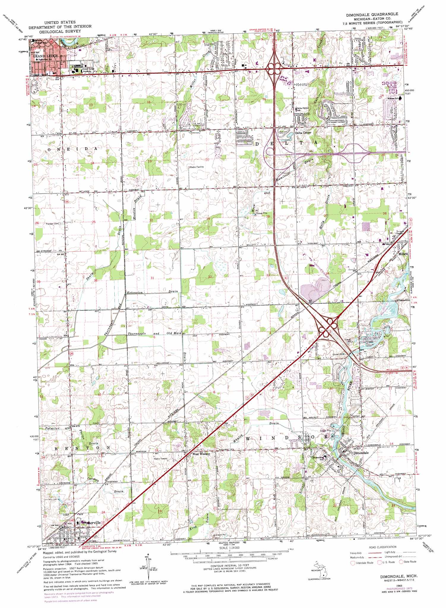
USGS Topo Quad 42084f6 - 1:24,000 scale
| Topo Map Name: | Dimondale |
| USGS Topo Quad ID: | 42084f6 |
| Print Size: | ca. 21 1/4" wide x 27" high |
| Southeast Coordinates: | 42.625° N latitude / 84.625° W longitude |
| Map Center Coordinates: | 42.6875° N latitude / 84.6875° W longitude |
| U.S. State: | MI |
| Filename: | o42084f6.jpg |
| Download Map JPG Image: | Dimondale topo map 1:24,000 scale |
| Map Type: | Topographic |
| Topo Series: | 7.5´ |
| Map Scale: | 1:24,000 |
| Source of Map Images: | United States Geological Survey (USGS) |
| Alternate Map Versions: |
Dimondale MI 1965, updated 1967 Download PDF Buy paper map Dimondale MI 1965, updated 1974 Download PDF Buy paper map Dimondale MI 1965, updated 1974 Download PDF Buy paper map Dimondale MI 2011 Download PDF Buy paper map Dimondale MI 2014 Download PDF Buy paper map Dimondale MI 2017 Download PDF Buy paper map |
1:24,000 Topo Quads surrounding Dimondale
Portland North |
Wasphalia |
Riley |
Saint Johns South |
Price |
Portland South |
Eagle |
Wacousta |
Lansing North |
Bath |
Hoytville |
Needmore |
Dimondale |
Lansing South |
East Lansing |
Chester |
Charlotte |
Eaton Rapids |
Aurelius |
Mason |
Olivet |
Duck Lake |
Springport |
Onondaga |
Leslie |
> Back to 42084e1 at 1:100,000 scale
> Back to 42084a1 at 1:250,000 scale
> Back to U.S. Topo Maps home
Dimondale topo map: Gazetteer
Dimondale: Canals
Carman Drain elevation 274m 898′Holly Drain elevation 262m 859′
Moon and Hamilton Drain elevation 262m 859′
Munton Drain elevation 263m 862′
Palmiter and Phelps Drain elevation 265m 869′
Sharp Drain elevation 262m 859′
Thornapple and Old Maid Drain elevation 261m 856′
Dimondale: Crossings
Interchange 70 elevation 269m 882′Interchange 72 elevation 265m 869′
Interchange 93A elevation 262m 859′
Interchange 93B elevation 262m 859′
Interchange 95 elevation 265m 869′
Interchange 98A elevation 274m 898′
Interchange 98B elevation 273m 895′
Dimondale: Lakes
Lake Delta elevation 269m 882′Dimondale: Parks
Delta Center Methodist Church Historical Marker elevation 263m 862′Delta Charter Township Historical Marker elevation 263m 862′
Delta Township Historical Marker elevation 262m 859′
Erickson Park elevation 268m 879′
First Presbyterian Church Historical Marker elevation 265m 869′
Potterville United Methodist Church Historical Marker elevation 278m 912′
Underhill Store Historical Marker elevation 262m 859′
Dimondale: Populated Places
Century Park Mobile Home Park elevation 264m 866′Delta Center elevation 264m 866′
Dimondale elevation 262m 859′
Independence Commons Mobile Home Park elevation 270m 885′
Potterville elevation 274m 898′
Valley Springs Mobile Home Park elevation 276m 905′
West Windsor elevation 286m 938′
Whaley Drain elevation 264m 866′
Windsor Estates Mobile Home Park elevation 272m 892′
Dimondale: Post Offices
Dimondale Post Office elevation 263m 862′Potterville Post Office elevation 277m 908′
West Windsor Post Office (historical) elevation 285m 935′
Dimondale: Streams
Silver Creek elevation 256m 839′Dimondale digital topo map on disk
Buy this Dimondale topo map showing relief, roads, GPS coordinates and other geographical features, as a high-resolution digital map file on DVD:
Northern Illinois, Northern Indiana & Southwestern Michigan
Buy digital topo maps: Northern Illinois, Northern Indiana & Southwestern Michigan